Gmina Grunwald
| Gmina Grunwald | ||
|---|---|---|

|
|
|
| Basic data | ||
| State : | Poland | |
| Voivodeship : | Warmia-Masuria | |
| Powiat : | Ostródzki | |
| Geographic location : | 53 ° 33 ' N , 20 ° 5' E | |
| Residents : | see Gmina | |
| Postal code : | 14-110 | |
| Telephone code : | (+48) 89 | |
| License plate : | NOS | |
| Economy and Transport | ||
| Street : | S7 Gdansk - Nidzica - (Warsaw) | |
| DW542 Rychnowo– Działdowo | ||
| DW537 Frygnowo– Lubawa | ||
| Rail route : | - | |
| Next international airport : | Danzig | |
| Gmina | ||
| Gminatype: | Rural community | |
| Gmina structure: | 21 school authorities | |
| Surface: | 179.84 km² | |
| Residents: | 5633 (June 30, 2019) |
|
| Population density : | 31 inhabitants / km² | |
| Community number ( GUS ): | 2815032 | |
| Administration (as of 2018) | ||
| Wójt : | Adam Szczepkowski | |
| Address: | Gierzwałd 33 14-107 Gierzwałd |
|
| Website : | www.gminagrunwald.pl | |
The Gmina Grunwald [ ˈgrunvalt ] is a rural community in the powiat Ostródzki of the Warmian-Masurian Voivodeship in Poland . Their seat is the village Gierzwałd ( German Geyerswalde ) with about 660 inhabitants.
The village was named after the village of Grunwald (Green Field) with 420 inhabitants, which is known nationwide as the site of the Battle of Tannenberg in 1410 ( Polish: Bitwa pod Grunwaldem - Battle of Grunwald ). The place Stębark (Tannenberg) on the other side of the battlefield was the site of the order's army .
geography
The municipality is located in the southwest of the voivodeship, in Masuria in the former East Prussia . Neighboring communities are the rural communities Ostróda (Osterode) in the north, Olsztynek (Hohenstein) in the east, Kozłowo (Koslau) in the southeast and Dąbrówno (Gilgenburg) in the south and west. The former and the latter are in the powiat Ostródzki, Olsztynek in the powiat Olsztyński and Kozłowo in the powiat Nidzicki .
There are several lakes in the southeast of the municipality. The Mielno with 547 hectares is their largest, the Tymawskie has 64 hectares. The most important flowing water is the 207 km long Drwęca (Drewenz) . Mielno and Drwęca partially form the eastern border of the municipality.
The community has an area of almost 180 km², 72 percent of which is used for agriculture and 18 percent for forestry.
history
The community was re-established in 1973, it belonged from 1975 to 1998 the province Olsztyn (Olsztyn) and came 1999 Warmia-Mazury.
In 1410, the army of the Polish-Lithuanian Union formed in the municipality east of the village of Gruenwald (Grunwald) and the knights of the order near Tannenberg (Stębark), one kilometer to the east. - The second battle "near Tannenberg" took place about 15 kilometers to the northeast in 1914, it was only called this for propaganda reasons .
structure
The rural community of Grunwald includes 21 villages (official German names until 1945) with a Schulzenamt (sołectwo):
- Domkowo (Domkau)
- Dylewo (Döhlau)
- Frygnowo (Frögenau)
- Gierzwałd (Geyerswalde)
- Glądy (Glendy)
- Góry Lubiańskie (Weißberg)
- Grunwald (green fields)
- Kiersztanowo (Groß Kirsteinsdorf)
- Kiersztanówko (Klein Kirsteinsdorf)
- Kitnowo (Kittnau)
- Korsztyn (Gut Korstein)
- Łodwigowo (Ludwigsdorf)
- Marcinkowo (Mertensdorf)
- Mielno (mills)
- Pacółtowo (Groß Pötzdorf)
- Rychnowo (Reichenau)
- Rychnowska Wola (Sophienthal)
- Stębark (Tannenberg)
- Szczepankowo (Steffenswalde)
- Zapieka (chewing fracture)
- Zybułtowo (Lake Forest)
Other smaller towns in the municipality are:
- Dąbrowo (Heinrichswalde)
- Dylewko (Elisenhof)
- Grabiczki (Geierseck)
- Jędrychowo
- Kalwa
- Lipowa Góra (Lindenberg near Hohenstein)
- Lubian (Great Lauben)
- Lubianek (Klein Lauben)
- Łącko
- Omin ( ohmen )
- Pacółtówko (Klein Pötzdorf)
- Rzepki ( Rzepken , 1938–1945: Vulture Cross )
- Tymawa (Thymau)
- Ulnowo (lazy)
- Wróble (wobble)
Attractions
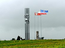
The Grunwald memorial with the Grunwald memorial is located east of Grunwald, in the direction of the village of Stębark (Tannenberg) .
traffic
The expressway S7 ( Europastraße 77 ) runs through the north of the municipality. It leads from the Rychnowo to Ostróda (Osterode i. Ostpr.) , Elbląg (Elbing) and Danzig as well as to Nidzica (Neidenburg) , while the expansion to Warsaw is not yet complete. In Rychnowo there is a connection to the DW542 voivodship road . This runs through the municipality and its main town from north to south and leads to Działdowo (Soldau) . In Frygnowo the voivodship road DW537 crosses which leads to Lubawa (Löbau in West Prussia) .
The nearest train station is Olsztynek (Hohenstein) on the Działdowo – Nidzica railway line .
The nearest international airport is Gdansk . - The hotel and equestrian center in Pacółtowo operates the required landing site Pałac Pacółtowo with a grass runway of 850 meters long and 30 meters wide.
Personalities
- Fedor von Kleist (1812–1871), Prussian major general; born on Gut Reichenau.
Web links
- Community website (Polish)
Individual evidence
- ↑ population. Size and Structure by Territorial Division. As of June 30, 2019. Główny Urząd Statystyczny (GUS) (PDF files; 0.99 MiB), accessed December 24, 2019 .
- ↑ a b regioset.pl: data on the municipality (Polish, accessed on May 29, 2020)
- ↑ gminagrunwald.pl: Sołectwa. (Polish, accessed May 29, 2020)
- ↑ The Historical Place Directory
- ↑ lotniska.dlapilota.pl: Pacółtowo. (Polish, accessed May 29, 2020)


