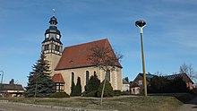
Grabo
|
Grabo
City of Jessen (Elster)
Coordinates: 51 ° 46 ′ 20 ″ N , 12 ° 56 ′ 8 ″ E
|
||
|---|---|---|
| Height : | 73 m above sea level NN | |
| Area : | 6.17 km² | |
| Residents : | 329 (Jun 1, 2017) | |
| Population density : | 53 inhabitants / km² | |
| Incorporation : | January 1, 1992 | |
| Postal code : | 06917 | |
| Area code : | 03537 | |
|
Location of Grabo in Saxony-Anhalt |
||
Grabo is a district of the town of Jessen (Elster) in the Wittenberg district of Saxony-Anhalt .
Location and accessibility
Grabo is located approx. 2 km southwest of the city of Jessen and is connected to it via the L114.
history
Grabo was first mentioned as a settlement in documents in 1376 under the name Grabow . The original place name corresponds in Slavonic to the name for the hornbeam , a subspecies of the birch family . The current spelling Grabo was established in 1533.
In 1890 the place was completely flooded by a flood . Another catastrophe that struck the place is a fire on September 27, 1898, which destroyed large parts of the place. The church chronicle also fell victim to the fire.
Web links
Commons : Grabo - collection of images, videos and audio files
Individual evidence
- ↑ http://www.jessen.de/stadtportal/ortsteile/grabo.html
- ↑ Grabo. In: jessen.de. Retrieved March 26, 2015 .


