Mönchenhöfe
|
Mönchenhöfe
City of Jessen (Elster)
Coordinates: 51 ° 47 ′ 0 ″ N , 13 ° 3 ′ 52 ″ E
|
||
|---|---|---|
| Height : | 75 m | |
| Area : | 5.98 km² | |
| Residents : | 138 (June 1, 2017) | |
| Population density : | 23 inhabitants / km² | |
| Incorporation : | March 1, 2004 | |
| Postal code : | 06926 | |
| Area code : | 035389 | |
|
Location of Mönchenhöfe in Saxony-Anhalt |
||
Mönchenhöfe is a place in the district of Wittenberg in Saxony-Anhalt (Germany), located directly on the Black Elster .
Geographical location
Mönchenhöfe is about 35 km southeast of Lutherstadt Wittenberg , and about 15 km northwest of Herzberg (Elster) .
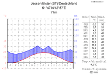
Mönchenhöfe is located in the cool, temperate climate zone . The next weather stations are to the west in Jessen (Elster) and east at the Holzdorf airfield . The month with the least rainfall is February, the wettest is June. The mean annual air temperature is 9.2 ° C at the Jessen weather station about 12 kilometers to the west.
history
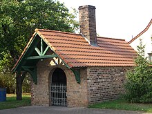
Premonstratensian monks from the Monastery of God's Grace near Calbe an der Saale acquired 60 Hufen land and a timber dump on the Schwarzen Elster in 1177 in order to obtain timber for the construction of the monastery. For this reason they built a farm between the Schwarzen Elster and the Kremitz so that they could cut wood in the woods on both sides of the Kremitz. Later, the village Mönchenhöfe emerged from this farm yard, which over the centuries has been given the following names: 1378 - Monchhouen, 1385 - Monchegehoue, 1424 - Monchenhofe, 1493 - Monichenhoff, 1528 - Munchhofen or Münchhofen 1617 - Mönchenhöfe. The name refers to the courtyards (homesteads) of the monks. In the 15th century Mönchenhöfe belonged to the Schweinitz office, is directly subordinate to it and was therefore no longer considered a knightly fiefdom. During the time of the Schmalkaldic War and the Battle of Mühlberg , the troops of Emperor Karl V were also in the area around Mönchenhöfe. During the Thirty Years War , the area was sacked and burned by troops of Gustav II Adolf (Sweden) under the command of General Bauer. It was not until 1653 that Mönchenhöfe and the surrounding areas were repopulated. In 1713 there were 10 hufners, 3 gardeners and 3 new farmers in Mönchenhöfe. In the 18th century a distinction was made in the size of the farms between hofners and gardeners ( kossaten ). A hoof in this area was about 100 acres in size, a gardener's food here was always smaller than a hoof. The first regulatory measures on the Black Elster began in 1852, but the dikes on the river were raised again in 1873. After devastating floods in 1926 and 1927, when up to 144 hectares of land were under water, the second large-scale straightening of the river began in 1928 . In 1984 the historic oven , which is located approximately in the center of the village, is restored. In 1987 Mönchenhöfe was connected to the water supply and disposal system. During the Elbe floods in 2002, the dikes on the Black Elster were also heavily stressed by the flood, and flood warning level 3 is valid for several days. In November 2003 the Heimatverein, which organizes events together with the local volunteer fire brigade , is founded. During the Elster floods from October 2010 with interruptions until January 2011, more than 200 comrades from the volunteer fire brigade, the Bundeswehr of the Holzdorf airfield , and the local residents were involved in the defense of the dykes of the Black Elster.
Leisure and Tourism
The 108-kilometer Schwarze-Elster Cycle Path runs past Mönchenhöfe . The local homeland association and the village's volunteer fire brigade have an impact on the local cultural life . Oven festivals are organized several times a year, at which not only bread, but also stollen and, depending on the occasion, pork knuckle is baked in the reconstructed historical and listed wood oven.
landscape
Mönchenhöfe is located directly on the Black Elster. The Annaburg Heath is about 5 kilometers upstream . This is mainly used for military purposes as a military training area and also for forestry. The Annaburg Heath is a sandy area with large forest dune complexes. In contrast to the flat Elbe and Elster floodplains, the height differences reach up to 26 m at a level between 75 and 101 m above sea level. NN. The oxbow lakes of the Black Elster are of particular importance from a nature conservation perspective. In the area of Mönchenhöfe, these waters are the old river courses of the Black Elster, which can still be easily recognized, before they were straightened.
Economy and Infrastructure
The most important employers in the vicinity are the Holzdorf airfield , 8 km away , the Annaburger Nutzfahrzeug GmbH in Annaburg and the local agricultural cooperative Holzdorf / Elster.
The district road 2220, which connects it with the federal road 187, runs through the village. The nearest train stations are in Holzdorf / Elster (train line Jüterbog - Riesa), Annaburg (train line Roßlau -Lutherstadt Wittenberg - Falkenberg / Elster) and Jessen / Elster (train line Roßlau-Falkenberg / Elster).
Attractions
- War memorial in honor of the fallen soldiers of the First and Second World Wars
- Bell tower - landmark of the place on the village green
- reconstructed historical wood oven
education
The local students are currently enrolled in the Schweinitz elementary school . In Jessen is more than an educational institution secondary school, which has the status of a full-time school. Also in Jessen there is the possibility to attend the grammar school from the 5th grade. The nearest daycare centers are in Holzdorf and Annaburg . Since the 2011/2012 school year it has also been possible to enroll children in the Holzdorf Evangelical Primary School.
media
The Mitteldeutsche Zeitung appears as a regional daily newspaper with a circulation of around 205,000 copies. The weekly advertising papers Wochenspiegel and Super Sonntag appear free of charge . The city of Jessen publishes the city gazette of Jessen every month.
literature
- List of monuments of the state of Saxony-Anhalt, district of Jessen, ISBN 3-910147-60-7 .
- Heimatbote - Our home then and now in words and pictures (1930–1941) Reprint 2011, Books Chamber Herzberg.
Web links
Individual evidence
- ↑ http://www.jessen.de/stadtportal/ortsteile/moenchenhoefe.html
- ↑ Home calendar for the Schweitnitz district, year 1926, page 52
- ↑ Heimatbote - Our home then and now in words and pictures (1930-1941) reprint 2011
- ↑ Chronicle
- ↑ List of monuments of the state of Saxony-Anhalt, Jessen district, page 51
- ↑ Chronicle of the historical development of the place - 2005 - ( Memento from February 22, 2014 in the Internet Archive )
- ↑ Landscape profile Annaburger Heide of the Federal Agency for Nature Conservation ( information )
- ↑ Archived copy ( memento of the original from January 6, 2016 in the Internet Archive ) Info: The archive link was automatically inserted and not yet checked. Please check the original and archive link according to the instructions and then remove this notice.


