Graner mountain
| Graner mountain | ||
|---|---|---|
|
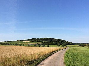
View from Wolfhagen south to Graner Berg |
||
| height | 315 m above sea level NHN | |
| location | near Wolfhagen , Kassel district , Hesse , Germany | |
| Mountains | Ostwaldecker Randsenken in the West Hessian mountainous region | |
| Coordinates | 51 ° 18 '26 " N , 9 ° 10' 27" E | |
|
|
||
| Development | Road to the summit area | |
| particularities | - Graner Berg towers - Drachenhöhle - Wolfhagen-Graner Berg airfield |
|
The Graner Berg is a 315 m above sea level. NHN high elevation of the Ostwaldecker peripheral depressions near Wolfhagen in the north Hessian district of Kassel .
The name of the elevation comes from the former church village Gran , a settlement of Chattisch - Saxon farmers from the end of the 4th century or, according to other information, from the 8th century; both fall in the centuries of Christianization . The elevation due to the Wolfhagen-Graner Berg airfield located on its high altitude is well known .
Geographical location
The Graner Berg is located in the Wolfhager hill country in the western part of the Habichtswald Nature Park . It rises between the core town of Wolfhagen in the north and its districts Istha in the east, Bründersen in the south-southeast and Leckringhausen in the west. The Erpe tributary Mühlenwasser flows to the west around the elevation . In the valley there are the Gran desert and the Granfeld settlement . The Glockenborn nature reserve near Bründersen (designated in 1995, 0.23 km² in size) stretches along the Mühlenwasser to the east , and beyond that lies the Todenhausen desert (first mentioned in 1074) with the Todenhausen cemetery .
Geology and landscape
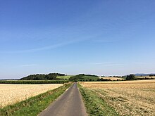
The Graner Berg consists of banky limestones of the 240 million year old shell limestone . The south-west, west and north slopes of its flat-topped elevation are forested, its high elevations are flat, extensive and without forests (this is where the airfield is located ) and the eastern slopes are partly used for agriculture.
Natural allocation
The Graner Berg lies in the nature spatial feature unit group West Hesse Highlands (no. 34) in the main unit Ostwald Ecker edge sinks (341), is in Wolfhager hills (341.3) predominantly to the natural space Isthaebene (341.34), said spur its north face up in the natural environment Ehringer sink ( 341.30) are enough.
Graner Berg Towers
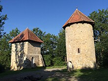
On the Graner Berg, a little west of the airfield, are the Graner Berg Towers . The two medieval-looking towers were only built between 1905 and 1909.
From 1946 Bruno Noll expanded the towers and existing barracks into his apartment and also set up a modest restaurant. This initially had neither electricity nor water connections; was initially flow by means of a current aggregate produced. Over the years he was able to expand the building complex as a home for the glider pilots and as an excursion restaurant. In 1961 he gave up his restaurant for reasons of age. It was taken over by Peppi Piretti. His lease contract ended in 1976. As a result, the residential and restaurant buildings fell into disrepair. To the regret of many Wolfhager, these were torn down. Only the two towers are still preserved.
The area on the towers is currently used as a barbecue and camping site.
Dragon cave
Almost 300 m south of the summit of the Graner Berg, the Drachenhöhle , which District Administrator Ludwig von Buttlar had drifted into the rock as a quarry at the beginning of the 20th century, spreads out on the slope towards the Mühlenwasser in the direction of the Gran desert and the Granfeld settlement to win the towers. A sign at the entrance said Dragon's Cave . Its winding rock corridor leads around 25 m into the rock; originally it served as an escape tunnel to both Graner Berg towers , but the connection there has been buried for a long time. In Bründersen it is said that refugees are said to have hidden in the cave during the war.
Wolfhagen-Graner Berg airfield
The plateau of Graner Berg was used by the National Socialist Air Corps (NSFK) as early as the 1940s . In 1950 the Wolfhagen Air Sports Association (LSV Wolfhagen) was founded. Since 1951 , the special airfield (SLP) Wolfhagen-Graner Berg ( ICAO code : EDGW) has been located on the elevation - east of the summit at a maximum height of around 313 m . For the construction of the airfield area, about 30,000 m³ of earth and rubble (etc.) were brought in and leveled by Belgian pioneer soldiers . On October 1, 1951, the first day of the flight took place in front of more than 5000 spectators. According to the responsible state aviation authority, the length and width of the grass- covered runway is 500 x 30 m. At the airfield operated by LSV Wolfhagen , not only gliders but also motor-powered aircraft (e.g. motor gliders ) may take off and land; model airplanes are also operated .
Transport links and hiking
Graner on the mountain can be reached via a Wolf on the Hagen to Ippinghausen leading national road incipient 3214 guideway (sign Sportflugplatz ), which ultimately quite steep uphill runs to the top and to the airport. The 52 km long Volkmarser Weg hiking trail ( Volkmarsen - Fritzlar ; waymark V ) in the Wolfhagen – Bründersen section and the 9.29 km long Granerbergweg hiking trail (W3) lead over the elevation . A forest path runs past the Graner Berg Towers and the Drachenhöhle.
Possibility of viewing
From the Graner Berg the view can be enjoyed especially in easterly directions to the Hinterhabichtswälder peaks with the Großer Bärenberg as well as to the Isthaberg and Hohen Habichtswald ; In addition, the Elsberg ridge can be seen in the north .
Individual evidence
- ↑ a b c Map services of the Federal Agency for Nature Conservation ( information )
- ^ Gustav Siegel: History of the city of Wolfhagen in Hessen , Wolfhagen 1929, page 2
- ↑ a b c d e f g h Information board: Habichtswald Nature Park - Graner Berg , Heimat- und Geschichtsverein 1956 Wolfhagen (2015)
- ↑ "Todenhausen, District of Kassel". Historical local dictionary for Hessen. In: Landesgeschichtliches Informationssystem Hessen (LAGIS).
- ↑ Martin Bürgener: Geographical Land Survey: The natural spatial units on sheet 111 Arolsen. Federal Institute for Regional Studies, Bad Godesberg 1963. → Online map (PDF; 4.1 MB)
- ↑ a b c article Where the dragon lives on hna.de from December 5, 2010
- ↑ Homepage of the Luftsportvereinigung Wolfhagen eV (LSV Wolfhagen) on edgw.de
- ↑ Deutsche Flugsicherung (DFS): AIP VFR Luftfahrthandbuch ( Ed. )


