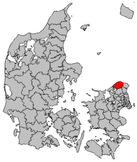
Gribskov commune
|
|
|||
|
|||
| Basic data | |||
|---|---|---|---|
| State : | Denmark | ||
| Region : | Hovedstaden | ||
| Region : | North Sealand | ||
| Educated: | 2007 | ||
| former municipalities : (until the end of 2006) |
Græsted-Gilleleje Municipality Helsinge Municipality |
||
| Office (until the end of 2006) : | Frederiksborg Office | ||
|
Harde : (until March 1970) |
Holbo Herred | ||
| Residents : | 41,048 (2020) | ||
| Area : | 279.50 km² (2014) | ||
| Population density : | 147 inhabitants per km² | ||
| Municipality number : | 270 | ||
| Administration headquarters: | Helsinge | ||
| Address: | Rådhusvej 3 3200 Helsinge |
||
| Mayor: | Gerner Frost is different | ||
| Website: | www.gribskov.dk | ||
Gribskov Kommune [ ˈgʀibsgɔu̯ʔ ] is a Danish municipality in the Hovedstaden region .
The municipality covers an area of 279.50 km² with a total population of 41,048 inhabitants (as of January 1, 2020).
The municipality was founded in the course of local government reform on January 1, 2007 and consists of the former municipalities of Græsted-Gilleleje and Helsinge in Frederiksborg Amt . It is the northernmost municipality in the Hovedstaden region and borders the Kattegat in the north, Helsingør municipality in the east, Fredensborg municipality in the southeast , Hillerød municipality in the south and Arresø and Halsnæs municipality in the southwest .
politics
Jannich Petersen from the liberal Venstre party was mayor of the municipality until December 31, 2009 . He was replaced by Jan Ferdinandsen from the Conservatives on January 1st 2010 . Anders Gerner Frost has been mayor since 2018.
Parish communities and localities in the municipality
The following parish communities ( Danish : Sogn ) and localities with over 200 inhabitants ( byer according to the definition of the Danish statistical office ) are located in the municipality , with a registered population of zero the place had more than 200 inhabitants in the past.
- Protected monuments in Gribskov commune
| No. | Parish | Residents | Locality | Residents |
|---|---|---|---|---|
| Anisse Sogn | 2,329 |
Anisse Anisse North |
298 1,537 |
|
| Blistrup Sogn | 4,584 |
Blistrup Rågeleje Smidstrup Udsholt Strand |
1,174 766 1,284 1,075 |
|
| Esbønderup Sogn | 2,047 |
Dronningmølle Esbønderup Esbønderup Kohave Esrum Hornbæk-Dronningmølle (part of several municipalities) |
January 1, 2009: 848 1,118 January 1, 2009: 285 532 1,693 |
|
| Gilleleje Sogn | 6,691 | Gilleleje | 6,658 | |
| Græsted Sogn | 5,068 |
Græsted Strand Esbønderup |
3,674 283 |
|
| Helsinge Sogn | 8,184 | Helsinge | 8,225 | |
| Mårum Sogn | 1,033 |
Kagerup Mårum |
406 223 |
|
| Ramløse Sogn | 3,059 |
Ramløse Skærød |
1,589 January 1, 2010: 642 |
|
| Søborg Sogn | 1,532 |
Munkerup Søborg |
January 1, 2009: 791 218 |
|
| Tibirke Sogn | 1,885 | Tisvilde | 1,533 | |
| Valby Sogn | 589 | |||
| Vejby Sogn | 2,873 |
Holløse Holløselund Vejby Vejby Strand Ørby |
346 360 1,089 383 310 |
|
| Villingerød Sogn | 1,068 |
- ↑ a b c The villages of Dronningmølle and Munkerup have been statistically counted as part of the Hornbæk-Dronningmølle settlement area since January 1, 2010 due to the expansion of their settlement area , with Hornbæk belonging to the Sogn of the same name in Helsingør municipality , which means that the settled area is part of two municipalities.
- ↑ a b The suburb Esbønderup Kohave belongs since 2010 statistically the village Esbønderup .
- ↑ a b Skærød has been considered part of Helsinge since 2011 .
Individual evidence
- ↑ a b c Statistics Banks -> Befolkning og valg -> BY1: Folketal January 1st efter byområde, alder og køn (Danish)
- ↑ a b Statistics Banks -> Geografi, miljø og energi -> ARE207: Areal demands efter municipality / region (Danish)
- ↑ danskekommuner.dk: Borgmesterffekta: Gribskov (Danish), accessed on April 16, 2020
- ↑ Statistics banks -> Befolkning og valg -> KM1: Befolkningen January 1st, April 1st, July 1st and October 1st, so and folkekirkemedlemsskab (Danish)
Web links
Coordinates: 56 ° 3 ' N , 12 ° 13' E


