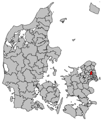
Furesø municipality
|
|
|||
|
|||
| Basic data | |||
|---|---|---|---|
| State : | Denmark | ||
| Region : | Hovedstaden | ||
| Region : | North Sealand | ||
| Educated: | 2007 | ||
| former municipalities : (until the end of 2006) |
Farum Kommune Værløse Kommune |
||
| Offices (until the end of 2006) : |
Frederiksborg Office København's Office |
||
|
Harden : (until March 1970) |
Smørum Herred Ølstykke Herred |
||
| Offices (until 1970) : |
Frederiksborg Office København's Office |
||
| Residents : | 40,965 (2020) | ||
| Area : | 56.80 km² (2014) | ||
| Population density : | 721 inhabitants per km² | ||
| Municipality number : | 190 | ||
| Administration headquarters: | Farum | ||
| Address: | Rådhustorvet 2 3520 Farum |
||
| Mayor: | Ole Bondo Christensen ( Social Democrats ) |
||
| Website: | www.furesoe.dk | ||
Furesø Kommune [ ˈfuːʀəsøːʔ ] is a municipality in the Danish region of Hovedstaden . It has 40,965 inhabitants (as of January 1, 2020) and an area of 56.80 km². The administrative headquarters are in Farum .
Furesø Kommune is located 20 km northwest of Copenhagen . In the municipal area there are large forest areas and several lakes, after the largest of these lakes, Furesø (German Furesee), the municipality is named.
The municipality lies on both sides of the former border between Frederiksborg Amt ( Ølstykke Herred ) and Københavns Amt ( Smørum Herred ). The municipality was created during the municipal reform on January 1, 2007 from the merger of the previously independent municipalities Farum in Frederiksborg Amt and Værløse in Københavns Amt.
Daughters and sons of the commune
- Frederik Madsen (* 1998), racing cyclist
Parish communities and localities in the municipality
The following parish communities ( Danish : Sogn ) and localities with over 200 inhabitants ( byer according to the definition of the Danish statistical office ) are located in the municipality , with a registered population of zero the place had more than 200 inhabitants in the past:
| No. | Parish | Residents | Locality | Residents |
|---|---|---|---|---|
| Farum Sogn | 20,947 |
Birkerød Farum |
4 20,345 |
|
| Hareskov Sogn | 3,754 | Hareskovby | 3,754 | |
| Værløse Sogn | 16,156 |
Kirke Værløse Smørumnedre Værløse |
953 1,279 12,926 |
- ↑ The town of Birkerød is mostly located in the area of Birkerød Sogn and Bistrup Sogn in Rudersdal Municipality , but also a small part in each case in the area of Blovstrød Sogn in Allerød Municipality and Farum Sogn.
- ↑ A part of the area of the municipality, which corresponds to the city of Hareskovby, belongs to the settlement area Hovedstadsområdet . In this area (within which no further places are differentiated) currently live 3754 inhabitants.
- ↑ The town of Smørumnedre is mainly located in the area of Måløv Sogn in Ballerup Municipality and Smørum Sogn in Egedal Municipality , but also to a small extent in the area of Værløse Sogn.
Attractions
Individual evidence
- ↑ a b c Statistics Banks -> Befolkning og valg -> BY1: Folketal January 1st efter byområde, alder og køn (Danish)
- ↑ a b Statistics Banks -> Geografi, miljø og energi -> ARE207: Areal demands efter municipality / region (Danish)
- ↑ danskekommuner.dk: Borgmester facta: Furesø (Danish), accessed on April 16, 2020
- ↑ Statistics banks -> Befolkning og valg -> KM1: Befolkningen January 1st, April 1st, July 1st and October 1st, so and folkekirkemedlemsskab (Danish)
Web links
Coordinates: 55 ° 48 ' N , 12 ° 22' E

