Hajniště
| Hajniště | ||||
|---|---|---|---|---|
|
||||
| Basic data | ||||
| State : |
|
|||
| Region : | Liberecký kraj | |||
| District : | Liberec | |||
| Municipality : | Nové Město pod Smrkem | |||
| Area : | 525.3635 ha | |||
| Geographic location : | 50 ° 56 ' N , 15 ° 12' E | |||
| Height: | 430 m nm | |||
| Residents : | 212 (March 1, 2001) | |||
| Postal code : | 463 65 | |||
| License plate : | L. | |||
| traffic | ||||
| Street: | Frýdlant - Nové Město pod Smrkem | |||
| Railway connection: | Frýdlant v Čechách – Jindřichovice pod Smrkem | |||
Hajniště , until 1946 Hegewald , is a district of the town of Nové Město pod Smrkem in the Czech Republic . It is located two and a half kilometers west of Nové Město pod Smrkem and belongs to the Okres Liberec .
geography
Hajniště is located on the right side of the Lomnice stream ( Lunzbach ) at the southwestern foot of the Heinersdorfer Ridge ( Jindřichovický hřeben ) in the Jizera foothills ( Frýdlantská pahorkatina ). The Hřebenáč ( Kohlhübel , 566 m) rises to the northeast, the Andělský vrch ( Schöbicht , 572 m) to the east, the Rapická hora ( Raplitz , 708 m), the Měděnec ( Kupferberg , 777 m) and the Svinský vrch ( Sauberg , 756 m), in the south the Závorník ( Riegelberg , 695 m) and southwest of the Chlum ( High Grove , 495 m). The village is bypassed in the south and north by the Neustädter Kehre of the railway line Frýdlant v Čechách – Jindřichovice pod Smrkem .
Neighboring towns are Cihelny and Horni Řasnice in the north, Jindřichovice pod Smrkem , Na Zámečku and Detrichovec in the Northeast, Podlesí and Nove Mesto pod Smrkem in the East, U Lesa in the southeast, Ludvíkov pod Smrkem and Peklo in the south, Luh, Raspenava and V Lukách in southwest , Frýdlant , Bažantnice and Krásný Les in the west and Dolní Řasnice in the north-west.
history
The first documentary mention of the Hegewald , which belonged to the Friedland lordship, took place in 1463. Later, the landlords had the zoo created in the forest. Under the Lords of Bieberstein , the area was separated from the Friedland- Seidenberg estate in the 16th century . Later the Lords von Maxen acquired the fief and built a Meierhof in the middle of the 16th century . In 1580 the Lords of Redern bought the farm on Friedland and added it to their rule.
Christian Philipp Clam-Gallas had the Meierhof closed in 1785; its corridors were parceled out and sold to subjects. Two years later, the founding document for the village of Hegewald , which was initially also called Neuhäuser , was issued. The establishment of the village was later associated with the visit of Emperor Joseph II in the Friedland dominion on September 16, 1779 in the local chronicle written by the teacher Emil Neumann. In 1790 Hegewald consisted of 19 houses, the residents of the village all lived from agriculture. The industrialization of Bohemian Neustadt that began at the beginning of the 19th century also spread to Hegewald. Franz Sulze set up a non-ferrous metal foundry in Hegewald, in which Josef Ressel also acquired technical knowledge of the casting of non-ferrous metals. In 1828 Karl Immanuel Persch founded a calico factory in Hegewald .
In 1832 Hegewald consisted of 37 houses with 175 German-speaking residents. In the place there was a manorial farm, a hunter's house, a grinding mill and a canvas pale . The parish was Neustadt. Until the middle of the 19th century, Hegewald remained subject to the allodial rule of Friedland .
After the abolition of patrimonial Hegewald formed from 1850 a district of the municipality Rückersdorf in the Bunzlauer Kreis and judicial district Friedland . In 1859, Karl Persch established a porcelain factory . From 1868 the village belonged to the Friedland district . In 1875 a branch of the Neustädter Schule was set up in Hegewald, which became independent just two years later. In 1890 the village had 370 inhabitants. Hegewald broke away from Rückersdorf in 1895 and together with the meadow houses formed a separate community. The volunteer fire brigade was formed in 1899. At the turn of the century, Adolf and Robert Persch brought the “royally privileged porcelain manufacturer Adolf Persch” to economic prosperity; the company had 150 employees and exported utility porcelain within Europe and to America. At that time the Kirch & Radon brickworks was built on the northern edge of the village; she burned special bricks made from a mixture of clay and quartz sand, which were also exported to Prussia. On August 2, 1902, the Friedland District Railway started operating the local railway line from Friedland to Heinersdorf . In 1910, 628 people lived in the 106 houses in Hegewald. From 1911 the municipality of Hegewald belonged to the newly formed judicial district Neustadt an der Tafelfichte . In 1921 the population had dropped to 474. In 1930 the community had 476 inhabitants. As a result of the global economic crisis , the brickworks ceased operations at the beginning of the 1930s. In 1935, the Adolf Persch porcelain factory also went bankrupt. After the Munich Agreement , it was incorporated into the German Reich in 1938; until 1945 Hegewald belonged to the Friedland district . In 1939 there were 412 people in Hegewald. After the end of World War II, Hegewald returned to Czechoslovakia and most of the German-Bohemian residents were expelled. In 1946 it was renamed Hajniště . In 1947 the place had 264 inhabitants. In 1949 Hajniště was incorporated into Nové Město pod Smrkem . At the beginning of 1961, the Okres Frýdlant was dissolved; Hajniště was assigned to the Okres Liberec . At that time there were 255 people living in Hajniště. In 1991 Hajniště had 103 inhabitants. In 2001 the village consisted of 71 houses, in which 203 people lived. In total, the place consists of 77 houses.
Local division
The district Hajniště forms the cadastral district Hajniště pod Smrkem . Hajniště includes the settlements Cihelny ( brick houses ) and V Lukách ( meadow houses ).
Attractions
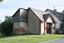
- chapel
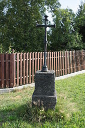
- crossroads
- House number 48, one of the oldest in the region
Web links
Individual evidence
- ↑ http://www.uir.cz/katastralni-uzemi/706507/Hajniste-pod-Smrkem
- ↑ http://www.zakonyprolidi.cz/cs/1947-123
- ^ Johann Gottfried Sommer , Franz Xaver Maximilian Zippe The Kingdom of Bohemia, Vol. 2 Bunzlauer Kreis, 1834, p. 317
- ↑ Michael Rademacher: German administrative history from the unification of the empire in 1871 to the reunification in 1990. Friedland district at the Jizera Mountains. (Online material for the dissertation, Osnabrück 2006).
- ↑ http://www.czso.cz/csu/2009edicniplan.nsf/t/010028D080/$File/13810901.pdf


