
Helmstedt (municipality-free area)
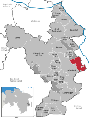
The community-free area Helmstedt is one of five community-free areas in the district of Helmstedt , Lower Saxony . The name of the area is derived from the neighboring district town of Helmstedt .
It has an area of 18.56 km² and borders clockwise in the west on the city of Helmstedt and in the north on the community-free area Mariental in the same district. In the east and south it borders on the district of Börde in Saxony-Anhalt .
The community-free area is uninhabited. For statistical reasons, however, it has the official municipality key 03 1 54 502.
Individual evidence
- ↑ a b Federal Statistical Office , All politically independent municipalities with selected characteristics on September 30, 2013
Bahrdorf | Beierstedt | Danndorf | Frellstedt | Gevensleben | Grafhorst | Grass life | Groß Twülpstedt | Helmstedt | Jerxheim | Königslutter am Elm | Teaching | Mariental | Querenhorst | Räbke | Rennau | Schöningen | Söllingen | Süpplingen | Süpplingenburg | Velpke | Warberg | Wolsdorf
Municipality-free areas in the Helmstedt
Brunsleberfeld district |
Helmstedt |
Königslutter |
Mariental |
Schöningen
Coordinates: 52 ° 15 ' N , 11 ° 3' E