
Hemmaberg
Coordinates: 46 ° 33 ′ 12 ″ N , 14 ° 40 ′ 2 ″ E


The Hemmaberg ( Slovenian : Gora svete Heme) is 842 m above sea level. A. high mountain in the apron of the Karawanken and is located west of the village Globasnitz in southern Carinthia . There has been a Celtic sanctuary on the summit plateau at least since Roman times . In late antique times there was a hillside settlement with an older church and two double churches built at the same time at the beginning of the 6th century . The settlement perished around 600. In the Middle Ages , a pilgrimage church was built on the summit, in the Rosalia grotto the plague saint Rosalia has been venerated since the baroque era . The name refers to Hemma von Gurk . The finds from the archaeological excavations are exhibited in the Archaeological Pilgrim Museum Globasnitz .
Natural history
The Hemmaberg is part of the Karawanken foothills and is located on the southern edge of the Jauntal, 5.4 kilometers west of Globasnitz. This was formed after the uplift of the Karawanken and the erosion that started with it in the Tertiary 12 to 14 million years ago. This resulted in conglomerates from the lime scree, which are referred to here as bear valley conglomerate . The geological map of the Republic of Austria 1: 50,000 shows the area as tertiary. The Hemmaberg slopes steeply on the north side, which meant that it only had to be fortified on three sides in ancient times. There is a spring in the Rosaliengrotte. The vegetation consists mainly of spruce forest, partly with deciduous wood indentations. There are meadows in the area of the Rosaliengrotte and the excavations on the plateau. A finger-tooth root-fir-beech forest is given as potential natural vegetation . The name of the property on the southern slope of the Hemmaberg, Gradischnigg, refers to the ruins on the summit, which were interpreted as a castle (Slovene grad ) (see also Grazerkogel ).
history

The first traces of settlement on the Hemmaberg date back to between 1500 and 1250 BC. Dated. The worship of a deity Iovenat (or Iouenat) mentioned only here is known from Roman times through an inscription. The inscription reads: Iouenat / Aug (usto) / Attia Ing [e] / nua v (otum) s (olvit) . (Attia Ingenua redeemed the vow to Iouenat Augustus.) Augustus is a common attribute in inscriptions for native deities. The name of the Roman settlement in the valley, Iuenna (in the area of today's Globasnitz ), as well as the medieval name of the mountain Iunberch or Jaunberg and finally that of the entire Jaun valley is derived from this deity . Iovenat is almost certainly a pre-Roman deity, as ceramics from the late Latène and early imperial periods were found in the finds . This speaks for a continuous settlement before and after the Roman occupation of Noricum . After Iuenna was founded on the valley floor, the mountain settlement was probably given up.
The late antique settlement emerged around 400 AD, when the inhabitants of Iuenna, as is widespread in Noricum around this time, left the unprotected settlement on the plain and retreated to protected heights. The first church was built to the east of the old sanctuary of Iovenat.
A fortification was built around the hilltop: a wall made of earth, stones and rubble, no masonry. The grave field with graves from the 5th and 6th centuries is located along the approach route, which is still the same today. The Eastern Gothic cemetery with 422 graves, which was occupied from 493 to 536 and was located at the Roman road station Iuenna, has been completely excavated.

Around 500/510 two twin churches were built at about the same time. The number and size of the churches, the two parish churches each held about 300 people, lead the excavator, Franz Glaser , to assume that the Hemmaberg was an early Christian pilgrimage center. He assigned the western double church to the Arians of the Ostrogothic period , the eastern to the Catholics . Between 493 and 536/537, i.e. at the time of construction, Inner Noricum was part of the Ostrogoth Empire. The splendid furnishings of the churches could therefore also have arisen from a certain rivalry between the two religions. The Arian double church was used profanely after the end of the Ostrogothic period. Bierbrauer , who assigns the churches to different political units in the wider area of the mountain, has a different opinion .
Ash remains over the mosaics as well as melted pieces of window pane show that the settlement perished by fire around 600 AD, probably in the course of the Slavic conquest.
Between 1498 and 1519 the Church of St. Hemma and Dorothea built partly with material from the church ruins. Since the 17th century at the latest, pilgrimages and the veneration of St. Rosalia occupied in the Rosaliengrotte. Around this time the name Hemmaberg has also been passed down for the mountain previously named Iunberg.
In 1887 K. Hauser reported on old masonry and finds on the Hemmaberg. However, scientific research did not begin until 1906, when the excavations of the eastern double church, which lasted until 1914, were carried out, especially by the notary H. Winkler, and which were published in 1916 by Rudolf Egger . Franz Glaser from the Carinthian State Museum has been leading the excavations since 1978.
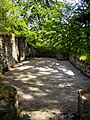
Since 2002 there has been a meditation path "ad fontes" on the Hemmaberg. The excavations are open to the public as an open-air museum, the mosaics are in the museum in Globasnitz. The foundations were preserved, the original floors are indicated by white marble gravel for mosaics and red limestone gravel for the red brick gravel screed. Gray-green quarry stone slabs indicate the location of the graves if the original grave slabs have not been preserved.
Rosalienkirchtag takes place on the third Sunday in September on the Hemmaberg. On this day, St. Masses are not only celebrated in the pilgrimage church, but also in the parish church of the eastern double church.
Excavations


The first church was built at the beginning of the 5th century and is an apse church . It is poorly preserved, which is why it was thought to be a chapel for some time. It is 15.8 × about 7 meters. There was a priest's bench in the apse. The presbytery is elevated and there is a reliquary pit in the place of the altar . A sacristy and another heated room of unknown function were built on the north side of the church . There are some graves on the south side of the church, and a separate room was even added to the apse for a grave. The remaining south and west sides were probably preceded by wooden halls. The graves are attributed to priests and church donors who had the privilege of being buried near the martyr's grave. To the north of the church is a cistern sunk into the rock and lined with clay .
In the vicinity of the church there are several stone houses interpreted as pilgrim houses with a floor area of up to 244 m², some of which have kitchens and floor-heated dining rooms. One-room stone buildings are seen as accommodation for the staff who looked after the pilgrimage shrine. Subdivisions by wooden walls are likely, but not tangible. As far as can be proven, both types of houses had hip roofs and a porch as a vestibule. There are also traces of a number of wooden buildings that are addressed as residential buildings for the population. Numerous fragments of storage jars and amphorae as well as iron scales were found in one building . Therefore, the building is interpreted as a storage building for the donations in kind, the scales were used to distribute the donations to the needy.
Eastern double church
The eastern double church complex was built like the western one around 500/510. In order to be able to build on the sloping terrain, around 200 cubic meters of earth had to be heaped up. The church buildings are east-facing and are on three levels: the parish church is on the uppermost plateau, the memorial church with the baptistery and the burial chapel follow to the south .
Parish church


The parish church has a rectangular floor plan 21.6 meters long and 8.5 meters wide. She served the celebration of the Eucharist . In the west there is a narthex , the vestibule for the unbaptized. In the eastern half is the raised presbytery with the semicircular priest's bench. The presbytery probably had a floor made of stone slabs, but these have not been preserved. The altar must have been in the axis in front of the priest's bench, but no remains of it were found. The presbytery was closed off by marble barriers that were open to the side steps and to the solea. The Solea is an elevated corridor along the longitudinal axis of the church that leads from the presbytery to the center of the church. Whether there was a lectern for the reading on the Solea or whether it was used by steps for the entry of the priests could not be reconstructed due to the poor state of preservation. The floor of the hall was covered with mosaics , which covered 140 m². Around 40 m² have been preserved and are now in the museum in Globasnitz. All the mosaics on the Hemmaberg are five-colored, the black, gray, white and pink stones are made of limestone, the red ones are made of bricks.
The western half shows bird motifs in plaited ribbon loops that form circles and squares. It depicts cranes , which the church fathers consider to be a symbol of order, vigilance and a sense of community, as well as various water birds. These are interpreted as an allusion to paradise . On both sides of the Solea the floor was provided with star-shaped flower ornaments. On the edges of the presbytery there was a Pelten ornament, around the priest's bench a vine tendril motif.
To the east of the church is a small sacristy, which could be entered from outside as well as from the church. On the north wall of the church there is a cistern with a sloping bottom. The screed consists of brick chippings.
Memorial Church

The second church is on a slightly lower level and is a rectangular hall 16.8 meters long and 8 meters wide. To the east is a 3.9 meter deep apse . A narthex is built in front of the west. In this church only the apse was decorated with a mosaic. Parts of it with a circular loop repeat, a peacock and remains of a donor's inscription have been preserved. Glass river stones in different shades of blue were used for the peacock. The rest of the church floor consisted of a brick chip screed. The priest's bench rises in front of the string of the apse. In the middle of the apse there is a pit that may have contained a reliquary. A reliquary grave could explain the highlighting of the apse by the mosaic as well as the peacock as a symbol of eternity. To the south of the apse outside the church and to the side of the presbytery in the church are two graves. In the first a woman was buried, possibly a donor, in the second a priest is assumed due to the location. Steps on the south side lead from the church to the burial chapel. In early Christianity, the veneration of relics was particularly promoted by Ambrosius , the bishop of Milan . A tomb near a martyr was considered a guarantee of resurrection. The church is therefore addressed as a memorial church (Gedächtniskirche). Confirmation was only given in such churches, which is why this church was formerly called the Episcopal Church.

Priest's bench of the memorial church

Reconstruction of the chancel
Donors Chapel
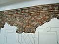
Mosaic from the donor chapel


The chapel adjoining the memorial church in the south repeats the ground plan of the memorial church in a smaller form measuring 8.5 × 3.9 meters. It was decorated with a mosaic and was probably built at the same time as the church. The mosaic shows knotted braided ribbon strips into which staggered triangles, two-strand braided ribbons and the " running dog " are inscribed as individual motifs . The braided tape strips result in large and small squares. The small squares are divided by star-shaped lines. The larger squares were not preserved well enough to reconstruct the contents, possibly they contained depictions of birds or inscriptions. An ivy leaf on a white background is used as the filling ornament , as is also used in the church of S. Eufemia in Grado . Ivy leaves have been a typical feature of Upper Italian workshops since the imperial era.
Baptistery

To the west of the memorial church is an octagonal baptistery . The two buildings were probably connected by an atrium, the floor is covered with a screed and there are traces of posts that could have supported a monopitch roof. The baptistery measures 7.2 and 6.8 meters in the axes. To the left and right of the entrance are two graves on the outside in the atrium area. In the north, from which the marble slab is still preserved, lay the skeleton of a man with a glass vial interpreted as a touch relic on his temple. A child was reburied in one corner of the grave. In the gusset between the atrium and the baptistery, the excavators found a third, severely disturbed grave.
The floor of the baptistery was covered with a mosaic that is divided into trapezoidal areas by braided loops. Six of them show different ornaments, two are provided with depictions of ducks and peacocks.
Western double church


The western double church complex was built at the same time as the eastern one and was about 25 meters away from it. Here, too, around 200 cubic meters of earth had to be poured in to obtain a level floor for the churches.
Parish church
The south church is an apse church 29.3 meters long and 9.55 meters wide. On the west side there is a narthex and a portal building. The clergy bench was built onto the inner apse wall. The presbytery is raised and was the only part of the church decorated with five-color mosaic: geometric patterns of semicircles (pelten) in the apse as well as diamonds and triangles with infill ornaments in front of the apse. The same leaf motif served as the filling ornament as in the eastern double church. In the place of the former altar, several details of the reliquary pit have been preserved: three vertical marble slabs supported the base plate of the cafeteria, the west side was open. A cross is carved into each of the two opposite panels on the inside.
In this pit was a marble box made from an older block. It is also marked with crosses and was found in 1992 during the archaeological investigation of a total of five historical churches in the pilgrimage shrine on Hemmaberg. In the box there was a reliquary , albeit destroyed . In addition to the fragments of the shrine, a silver finger ring and the bones of a martyr were found during the excavation. The woman had a healed collarbone and vertebral fracture that left her paralyzed. Most of the skull and a pelvic vane were missing. The examination of her bones revealed that the woman who was venerated at Hemmaberg had lived in the region during the early persecution of Christians and died in the 1st or 2nd century. This means that the find is “the oldest saint in Austria”.
The elaboration of the shrine can be an origin from the eastern Mediterranean, particularly from Syria or Cyprus , include: There is a small sarcophagus with a roof-like cover on the corners and long sides acroteria are worked out. They show a cross against a rough background, which was originally provided with red stucco. In this way stone inlays were imitated (Champlevé technique). The bones of the martyr were buried in 2004 under the new popular altar of the Church of St. Hemma and Dorothea.
The presbytery was probably delimited with wooden barriers. There are several graves inside and outside the church. Under the floor screed remains and a heating duct were uncovered and small finds recovered, including Eastern Mediterranean and North African Sigillata and Alamannic bow brooch . From the north side of the presbytery one reaches the sacristy, from there to the west into an elongated hall which is attached to the north side of the church. The northern foundation of the hall probably served as the foundation for wooden supports.
Baptistery
The north apse church was 24.2 meters long and 13.5 meters wide. It is shifted to the west opposite the southern church. The floor plan is also slightly shifted due to the hillside location. The church has a re-entrant apse that is not the width of the nave and transverse annexes that resemble a transept. The floor plan is therefore cruciform. The eastern third is on a higher level, two stairs on the north and south walls lead up. On the western edge there is a baptismal font, a piscina . The church was used for baptism and confirmation.
The narthex in the west is slightly lower than the nave, but at the same height as the hall that adjoins the south wall of the church. The church is accessed from the south side of the narthex. There are graves in the nave and in the narthex.
Excavations 2009-2013
Excavations in the north and east of today's pilgrimage church have shown that today's church was built on a previous building from the 6th century. In addition, older building remains were found, which can be assigned to the Roman sanctuary.
The find of grave 6, which was located parallel to the north wall of today's pilgrimage church, received national reports. Grave 6 is a 6th century burial of a Frankish man who was equipped with a wooden prosthesis on his left leg . It is the oldest proven prosthesis in Europe.
Pilgrimage church

The branch and pilgrimage church of St. Hemma (patronage June 27) and Dorothea (patronage February 6) is located northwest of the excavations at the highest point of the plateau. It is documented that it was built between 1498 and 1519. The polygonal choir and the eastern part of the nave go back to this late Gothic building . In the west is the baroque extension from the second half of the 17th century. It is possible that this part is also older and was subsequently baroque. The tower on the south side has a curly pointed helmet. On the north side of the nave, a polygonal baroque chapel was added, which was consecrated in 1681. The west portal is late Gothic, profiled and arched. A Roman cornice fragment serves as the threshold. In the tower there is a funerary inscription for C. Secundinius Secundus, Mayor of Celeia , and his wife Materna.
The nave has five bays and baroque vaults. The three western bays are barrel vaults with lancet caps, the two eastern bays are groin vaults. The choir has a 5/8 end and a ribbed vault on round pillars. The sacristy is located on the tower ground floor and has a late Gothic sacristy portal. There are late Gothic tracery windows in the choir and in the eastern nave yoke. The star rib vaults of the choir were decorated in 1619 with depictions of the four evangelists and the four church fathers in Secco painting. The resurrection of Christ is depicted on the north wall of the ship and the Last Judgment on the east side. In the nave there are pictures depicting scenes from the legend of Saint Hemma.
The high altar and the two side altars date from 1662, the statues of the high altar from the 19th century. The left altar panel shows Saints Bartholomäus and Christophorus , the right one Urban and Erasmus . Two other side altars and the altar in the chapel date from the late 17th century.
In 2004 the people's altar was designed by Boris and Aleksander Čipan. They used parts from the late antique northern church of the western double complex: stone slabs with an engraved cross, the stone box and a reconstruction of the reliquary in which the bones of the saints are buried.
The consecration altar for Iovenat, already described, is in the church.
Rosalia Grotto


A spring rises in the Rosaliengrotte, a little below the ancient settlement, which the late ancient settlement used to supply water. The spring still flows today. The Rosalienkapelle is located in the grotto.
In 1669 a statue of St. Rosalia was placed in the grotto , which the superior of Eberndorf Abbey in Marburg had made. In 1680 the parishes of Eberndorf , St. Kanzian , Stein (= Jaunstein ), St. Veit, Galizien , Sittersdorf and Kappel (= Eisenkappel ) vowed to build a chapel, should the area be spared from the plague. In 1681 the chapel was consecrated in a procession with 23 priests and 1,000 people.
Today's wooden chapel was built after a fire in 1926. The design for the statue of St. Rosalia comes from Switbert Lobisser , it was executed by the South Tyrolean sculptor Stefan Planker, who signed the work with Lobisser's initials.
There are numerous traces of machining on the rock walls. They suggest that the grotto was walled up in ancient times in order to dammed up the spring water. It was probably possible to get into the grotto via wooden structures from the plateau, i.e. within the fortification walls, while the actual entrance was outside.
literature
- Franz Glaser: The Roman settlement Iuenna and the early Christian churches on Hemmaberg. Verlag des Geschichtsverein für Kärnten, Klagenfurt 1982 (without ISBN; description of the excavation and the Rosaliengrotte).
- Franz Glaser: Early Christian monuments in Carinthia. Carinthia-Verlag, Klagenfurt 1997, ISBN 3-85378-450-X , pp. 35-54 (especially description of the western double church).
- Franz Glaser: Celts, Romans, Carantans. Carinthia, Klagenfurt 1998, ISBN 3-85378-465-8 .
- Franz Glaser: The pilgrimage church on the Hemmaberg / Romarska cerkev svete Heme. Kunstverlag Peda, Passau 2006, ISBN 978-3-89643-648-1 .
- Michaela Binder, Sabine Ladstätter : The Saint from Hemmaberg. Cold case of a relic. Verlag Holzhausen, Vienna 2018, ISBN 978-3-903207-19-6 .
Web links
- Archaeological excavations on the Hemmaberg
- Information about the Hemmaberg on the Globasnitz homepage
Individual evidence
- ↑ a b cath. Church: ad fontes folder. Archived from the original on March 3, 2007 ; Retrieved February 21, 2008 .
- ^ Karl Krainer: Geology at a Glance . In: Paul Mildner, Helmut Zwander (Ed.): Carinthia - Nature. The diversity of a country in the south of Austria. Verlag des Naturwissenschaftlichen Verein für Kärnten, 2nd edition, Klagenfurt 1999, ISBN 3-85328-018-8 , pp. 179–188, here 187.
- ↑ Retrieved from Kärnten Atlas , April 27, 2013.
- ^ Helmut Hartl, Roland Stern, Martin Seger : Map of the current vegetation of Carinthia. Natural Science Association for Carinthia, Klagenfurt 2001, ISBN 3-85328-024-2 .
- ↑ card forest communities (PNWG) in Carinthia Atlas , accessed April 27, 2013.
- ↑ a b c d Franz Glaser: Globasnitz. In: Gernot Piccottini : The Romans in Carinthia. Carinthia-Verlag, Klagenfurt 1989, ISBN 3-85378-333-3 , pp. 46-53.
- ↑ CIL 3, 14366.3
- ^ Translation quoted from Die Roman Siedlung Iuenna and the early Christian churches on Hemmaberg , p. 42.
- ↑ Thomas Fischer: Noricum . Zabern's illustrated books on archeology, Philipp von Zabern, Mainz am Rhein 2002, ISBN 3-8053-2829-X , pp. 152–155.
- ↑ a b c d e Franz Glaser: Celts, Romans, Carantans. Carinthia-Verlag, Klagenfurt 1998, ISBN 3-85378-465-8 , pp. 145-149.
- ^ Franz Glaser: Provincial Roman Archeology and Ancient Numismatics with the Roman Museum Teurnia and Archaeological Park Magdalensberg. In: Rudolfinum. Yearbook of the State Museum of Carinthia. 2015, p. 82 (full article, p. 60–91, PDF on ZOBODAT , also on academia.edu ).
- ^ Paul Gleirscher : Church dispute and church building at Hemmaberg and in Teurnia. In: P. Gleirscher: Mystical Carinthia. The legendary, the hidden, the excavated. Carinthia, Klagenfurt 2006, ISBN 3-85378-603-0 , pp. 119-125.
- ↑ after Th. Fischer: Noricum . Zabern's illustrated books on archeology, Philipp von Zabern, Mainz am Rhein 2002, ISBN 3-8053-2829-X , p. 154. Original work (not viewed): Volker Bierbrauer: Arian churches in Noricum mediterraneum and Raetia II? Bavarian history sheets, Volume 63, 1998, pp. 205-226.
- ^ Franz Glaser: The Roman settlement Iuenna and the early Christian churches on Hemmaberg , 1982, p. 7f.
- ↑ a b c Franz Glaser: Celts, Romans, Carantans. Carinthia-Verlag, Klagenfurt 1998, ISBN 3-85378-465-8 , pp. 112-116.
- ↑ "The Saint from Hemmaberg". Multidisciplinary research on a relic of late antiquity . Austrian Archaeological Institute of the Austrian Academy of Sciences, accessed on December 10, 2018.
- ↑ Press release: The oldest saint in Austria identified . Austrian Archaeological Institute, December 6, 2018, accessed December 10, 2018.
- ^ Report on the solemn consecration of the popular altar and burial of the relics of a Syrian martyr whose name is unknown. Archived from the original on December 21, 2005 ; Retrieved February 22, 2008 .
- ^ Josef Eitler: Another church from the 6th century on the summit of the Hemmaberg. In: Elisabeth Trinkl (Ed.): Files of the 14th Austrian Archaeological Day at the Institute for Archeology at the University of Graz from April 19 to 21, 2012. 2014.
- ^ Josef Eitler: Hemmaberg excavation 2012. In: Rudolfinum. Yearbook of the State Museum of Carinthia. 2012, p. 81 ( PDF on ZOBODAT ).
- ^ Josef Eitler, Johannes Reiter: New research on the Hemmaberg - surprising results of the excavation on the summit plateau. In: Rudolfinum. Yearbook of the State Museum of Carinthia. 2009/2010, p. 71 ( PDF on ZOBODAT ).
- ↑ Discovered the oldest prosthesis in Europe
- ↑ CIL 3, 5079
- ↑ The description of the church follows: Dehio - Die Kunstdenkmäler Österreichs: Kärnten. Verlag Anton Schroll, Vienna 1981, ISBN 3-7031-0522-4 , p. 223; Franz Glaser: The pilgrimage church on the Hemmaberg / Romarska cerkev svete Heme. Kunstverlag Peda, Passau 2006, ISBN 978-3-89643-648-1 .