
Hengchun
|
Hengchun 恆春 鎮 |
|||
.svg) Location Hengchuns in Pingtung County |
|||
| State : |
|
||
| County : | Pinging | ||
| Coordinates : | 22 ° 0 ′ N , 120 ° 45 ′ E | ||
| Area : | 136.7630 km² | ||
| Residents : | 30,669 (2017) | ||
| Population density : | 224 inhabitants per km² | ||
| Time zone : | UTC + 8 (Chungyuan time) | ||
| Telephone code : | (+886) (0) 8 | ||
| Postal code : | 946 | ||
| ISO 3166-2 : | TW-PIF | ||
| Community type : | City municipality ( 鎮 , Zhèn ) | ||
| Structure : | 17 districts ( 里 , Li ) | ||
| Website : | |||
|
|||

Hengchun ( Chinese 恆春鎮 ) is a township in Pingtung County on Taiwan ( Republic of China ).
Location, climate
Hengchun is located at the very southern tip of Taiwan . The South China Sea extends to the west and the Philippine Sea to the east . The two oceans of the Pacific are connected by the 320-kilometer-wide Luzon Strait south of Hengchun , which separates Taiwan from the main island of Luzon in the Philippines .
The climate is tropical and warm and characterized by the monsoons . The average annual precipitation is over 2000 mm and the rainiest months are May to October. The northeast monsoon, which blows from September to May, on the other hand, often brings dry winds that affect the climate on the east coast. In the following table, rainy days are defined as days with precipitation over 0.1 mm.
| Hengchun | ||||||||||||||||||||||||||||||||||||||||||||||||
|---|---|---|---|---|---|---|---|---|---|---|---|---|---|---|---|---|---|---|---|---|---|---|---|---|---|---|---|---|---|---|---|---|---|---|---|---|---|---|---|---|---|---|---|---|---|---|---|---|
| Climate diagram | ||||||||||||||||||||||||||||||||||||||||||||||||
| ||||||||||||||||||||||||||||||||||||||||||||||||
|
Climate data from the years 1981–2010
Source: Taiwan Central Weather Bureau
|
||||||||||||||||||||||||||||||||||||||||||||||||||||||||||||||||||||||||||||||||||||||||||||||||||||||||||||||||||||||||||||||||||||||||||||||||||||||
As part of Taiwan, Hengchun is located in an earthquake area . The 2006 Hengchun earthquake on December 26, 2006 - with a magnitude of 7.1 M wb and the epicenter 22.8 kilometers southwest of the coast of Hengchun - caused relatively minor personal injury (there were two fatalities when a house collapsed in Hengchun) but several submarine cables , so that the Internet and telephone traffic between Taiwan and the southern neighboring countries as well as between China, the United States and Japan were temporarily severely disrupted. The event highlighted the importance of the submarine cable networks and their susceptibility to seaquakes.
history
Older names of Hengchun are Longkiauw (瑯 嶠), Niangjiao and Langjiao . Longkiauw is a phonetic translation from Dutch, while Niangjiao and Langjiao come from place names from the Paiwan language. There are various theories about the origin of Longkiauw (in another spelling Lonkjouw ). The site was first known under the current place name Hengchun in 1874. In 1871 the so-called Mudan Incident occurred. A group of fishermen from to Japan belonging Ryukyu Islands had suffered on the coast of Hengchun shipwreck, had gone ashore and had gone further into the mountainous interior. There they were attacked and massacred by Taiwanese natives of the Paiwan people, who at that time still practiced headhunting . A total of 54 fishermen died while 12 were rescued with the help of local Chinese. Japan viewed this incident as an affront and dispatched a punitive military expedition to Taiwan in 1874 . The Chinese government sent a special envoy, Shen Bao-zhen (沈葆楨), to regulate local conditions, who in his reports described the local climate as “eternal spring”. Shen recommended the establishment of a permanent settlement and an administrative base and the community was given its current name (恆 'constant', 春 'spring', also 恆春, Hengchun = "continuous spring"). It was the first such administrative unit in what is now Pingtung County. In the years after 1875 a small fort was built here. During the Japanese rule over Taiwan from 1895 to 1945, the settlement was named Kōshun .
On January 16, 1946, Hengchun was raised to a township (鎮, Zhèn).
| Outline of Hengchun |
|
Jiahu
茄 湖 Tougou
頭 溝 Renshou
仁壽 Wangsha
網 紗 Dehe
德 和 Shanjiau
山腳 Nanwan
南 灣 Kenting
墾丁 Eluan
鵝 鑾 Shuiquan
水泉 Daguang
大 光 Longshui
龍 水 Sigou
四 溝 Sanmin
三民 a
b
c
a: Chengbei, 城北
b: Chengxi, 城西
c: Chengnan, 城南
|

Administrative division
Hengchun is bordered by Manzhou Rural Community to the west and Checheng Rural Community to the north .
Hengchun is further divided administratively into 17 districts (里, lǐ): Chengnan (城南), Chengbei (城北), Chengxi (城西), Shanjiau (山腳), Wangsha (網 紗), Renshou (仁壽), Jiahu (茄 湖), Tougou (頭 溝), Sigou (四 溝), Dehe (德 和), Longshui (龍 水), Shanhai (山海), Daguang (大 光), Shuiquan (水泉), Nanwan (南 灣), Kenting (墾丁) and Eluan (鵝 鑾).
population
The original inhabitants of the region were the indigenous peoples of Taiwan , particularly the Paiwan. Since the 19th century, the indigenous people have been increasingly displaced by Han Chinese, who themselves or their ancestors came from mainland China.
Economy, infrastructure
The predominantly cultivated landscape products include litchi , coconut palms and onions . Fishing plays an important role. Tourism is also of great importance and various government agencies are trying to promote nature and ecotourism.
Hengchun has no rail connection. There are several bus connections to Kaohsiung . In 2004 a small regional airport was opened, the closure of which is discussed due to low traffic.
The two reactor blocks of the Maanshan nuclear power plant, Taiwan's last still operating nuclear power plant, are located in Hengchun .
Attractions
Hengchun is largely (106.7718 km²) in Kenting National Park and has numerous sights. In the old town of Hengchun, the city wall and the old fort have largely been preserved. Excursion destinations are Cape Eluanbi , the southernmost point of Taiwan and several beaches.

Kenting night market (墾丁)

town hall

South gate to the fort in Hengchun
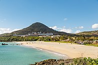
Beach in Kenting


Web links
Individual evidence
- ↑ a b The Hengchun Peninsula — A Green Treasure Store of Culture and Creativity. Taiwan Ministry of Foreign Affairs, October 30, 2017, accessed November 18, 2017 .
- ↑ M 7.1 - Taiwan region, 2006-12-26, 12:26:21 (UTC), 21.799 ° N 120.547 ° E, 10.0 km depth. In: Earthquake Hazards Program. USGS , accessed November 13, 2019 .
- ↑ Asia communications hit by quake. BBC News, December 27, 2006, accessed November 17, 2017 .
- ↑ Winston Qiu: Submarine Cables Cut after Taiwan Earthquake in Dec 2006. submarinenetworks.com, March 19, 2011, accessed November 17, 2017 .
- ^ History of Hengchun. hengchuen.gov.tw, accessed on November 16, 2017 .
- ↑ James W. Davidson: The island of Formosa, past and present. History, people, resources, and commercial prospects. Tea, camphor, sugar, gold, coal, sulfur, economical plants, and other productions . Macmillan & Co., London and New York 1903, p. 597 (English, online ).
- ↑ About Pingtung: Agriculture. Pingtung County Government, accessed November 16, 2017 .
- ↑ Traffic. hengchuen.gov.tw, accessed on November 17, 2017 .
- ↑ 各 國家 公園 基本 資料 表 (“Basic information table about the national parks”). October 5, 2009, Retrieved July 6, 2019 (Chinese (traditional), English).