Königsheide (Marienheide)
|
Königsheide
Municipality Marienheide
Coordinates: 51 ° 5 ′ 46 ″ N , 7 ° 29 ′ 6 ″ E
|
||
|---|---|---|
| Height : | approx. 370 m | |
| Residents : | 42 (Nov 24, 2005) | |
| Postal code : | 51709 | |
| Area code : | 02264 | |
|
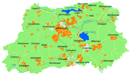
Location of Königsheide in Marienheide |
||
Königsheide is a district of the municipality of Marienheide in the Oberbergisches Kreis in North Rhine-Westphalia .
Location and description
The very small place belonging to the municipality of Marienheide is located about 3.5 km from the community center, and right on the border with the area of the Hanseatic city of Wipperfürth . The place is connected to traffic via Marienheider Straße.
A few hundred meters north of the village is the Wahlberg, with a summit height of 406 meters, on the eastern flank of which the 13 hectare Steinbruch am Wahlberg nature reserve is designated.
In the immediate vicinity, in the area of the village of Gogarten , the Gogarten fairy tale forest (named after the village of the same name), an attraction for families with children, was located until the 1980s.
The Gaulbach rises in Königsheide and flows into the Wupper in Wipperfürth.
economy
From September 1, 1999, Königsheide was the seat of a transport company . The transport company has not been based in the area since 2009.
leisure
Hiking and biking trails
- The historic hiking trail X 16, Eitorf - Wipperfürth leads through Königsheide.
- The A2 circular hiking trail also leads from Ohl up the Wahlberg to Königsheide and back via Obergaul, Nagelsgaul, through the Klüppelberg and Niederklüppelberg wooded areas.
Sports
The association TUS Kempershöhe Marienheide eV 1964 has its association headquarters in Königsheide.
Individual evidence
- ↑ Wupperverband; River basin geographic information system

