Kaltenlengsfeld
|
Kaltenlengsfeld
City of Kaltennordheim
Coordinates: 50 ° 38 ′ 27 ″ N , 10 ° 11 ′ 31 ″ E
|
|
|---|---|
| Height : | 535 m above sea level NHN |
| Area : | 9.73 km² |
| Residents : | 416 (December 31, 2012) |
| Population density : | 43 inhabitants / km² |
| Incorporation : | December 31 2013 |
| Postal code : | 36452 |
| Area code : | 036966 |
|
Districts of the city of Kaltennordheim
|
|
Kaltenlengsfeld ( Rhöner Platt : Längfd) is a district of the town of Kaltennordheim in the Schmalkalden-Meiningen district in Thuringia . The place belongs to the Rhön Biosphere Reserve .
geography
Geographical location
Kaltenlengsfeld is located in the Thuringian Rhön in a side valley of the Middle Felda Valley , which flanked the Vordere Rhön to the west. The place is located 18 kilometers (as the crow flies) northwest of the district town of Meiningen .
mountains
The landscape around Kaltenlengsfeld is determined by the mountains and peaks of the Rhön. The highest point of the district is on the Hohen Rain ( 702.8 m above sea level ). The community partly owns the eastern part of Umpfen ( 700.6 m above sea level ), and the northern part of Hohenstein ( 671.8 m above sea level ).
Waters
In the district, several source streams form the Ziegelbach , a right tributary of the Felda .
geology
At the Enzlerbach , south of the village, a limestone quarry was operated; today it serves as a geological outcrop of the Upper Wellenkalk , a rock formation from the Triassic ( Lower Muschelkalk section ). The Umpfen is an example of the volcanism in Rhon in the Triassic .
history
Prehistory and early history
Kaltenlengsfeld is located in a landscape that was already densely populated in prehistoric times. In 1754 the first excavations were made in the grove during fieldwork. The ramparts at the summit of Umpfen, along with the neighboring systems of Hessenkuppe ( Dermbach ), Diesburg ( Aschenhausen ), Arzberg ( Geisa ), Baier ( Weilar ), Horn ( Urnshausen ), Alte Mark ( Erbenhausen ) and others, form part of an extensive system of fortifications used by the Celts . To the south of the ramparts are several round and elongated stone mounds, presumably tombs; Even arable terraces are still clearly visible on the northern slope.
First mention
As early as 819, the place was first mentioned in a Fulda document as Lengifeld . The place in the Tullifeld belonged to Eastern Franconia at that time .
Kaltenlengsfeld in the Middle Ages
Field names such as Kaisershecke , Kaisersgraben and Streitgrund probably result from the area around the battle of Mellrichstadt between King Heinrich IV , the later emperor (from 1084), and his opponents Rudolf von Schwaben and Otto von Northeim in 1078.
Kaltenlengsfeld was home to a noble family - the Lords of Lengisfeld . The place belonged from time immemorial to the office Kaltennordheim , but around 1400 it was incorporated into the center Friedelshausen (later the office sand ).
At the time of the Reformation
It can be assumed that Christianity gained a foothold in this area quite early on. Before the Reformation , Kaltenlengsfeld and Oepfershausen were branches of Friedelshausen, until the Lords of Herda in Oepfershausen founded a “Vicariate of Early Mass”. In 1542 the vicar of Oepfershausen accepted the Protestant religion, "but remained a curse and brawler as before, rebelled against his pastor at Friedelshausen with a deadly rifle ...". Oepfershausen became an independent parish and Kaltenlengsfeld became a branch.
At the time of the Thirty Years' War , in which most of the surrounding Rhöndörfer suffered from the atrocities, Kaltenlengsfeld was spared. According to the local legend, it should have been due to the following circumstance: On the west gable side of our church there was said to have been a small cross with a weather vane on the ridge. The robbery of the Croats is said to have considered the church and thus also the inhabitants to be good Catholic and good imperial, thus the church and the place were saved from destruction. Perhaps the somewhat hidden location of the place also played a major role. In 1635, 250 people died between July and the New Year of probably imported epidemics.
In the first surviving description by Kaltenlengsfeld from 1668 it says: “In the village there is a church, a schoolhouse, an inn, five ovens, a brewery, a square and a grinder. There are 44 fire pits and 188 souls live in them. At the three places where you can enter the village, this is barely barred with a barrier. ”There are also indications that people have thought about fighting the fire. It says: "The three fountains and three spring wells of the place are again provided with fire hazard with leather buckets, fire picks and ladders." The church was built in 1722. In 1848 the village school was built and inaugurated.
19th century
The lords of Vasolt and von Auerochs were represented in the village with possessions in the 19th century. The village remained undisturbed from the time of the Napoleonic Wars . It is only reported that the miller saw a French soldier approaching his house. Fearful, the miller lay down in bed with his clothes and pretended to be asleep. But the soldier only asked for directions.
In 1842 the road to Kaltennordheim was built. Before that, there had only been one ravaged ravine that ran along the Kisselbach. In 1847/1848 a road connection to Oepfershausen was created. Before there had been no way, and therefore it could happen (1730 and 1760) that strangers would find death in the storm and snow. In the revolutionary year of 1848 there was a vigilante group in the village that was disbanded after a short time.
In 1866, during the German War , the battle between Prussia and Bavaria took place in nearby Roßdorf. Kaltenlengsfeld was occupied by Bavarian troops on July 3, 1866. When the Bavarian troops withdrew on the evening of July 4th, all available teams had to drive war material. A memorial stone in the village reminds of the warlike events.
Population development
In 1955 there were 728 inhabitants.
Development of the population:
|
- Data source: from 1994 Thuringian State Office for Statistics, values from December 31
Culture and sights
As part of the Sparkassen-Kulturstiftung , the Düsseldorf- born author Vera Vorneweg received the “Artists in rural areas” scholarship in autumn 2018 and spent two months in Kaltenlengsfeld. Under the working title “From the big city plant to the country egg”, she collected stories and anecdotes that will be published in 2019 in a “novel of the many”.
Buildings
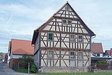
- The village church of Kaltenlengsfeld is a baroque choir tower church from 1721 with older parts, which houses a baroque interior in impressive unity and an important historical organ by Johann Caspar Rommel .
- The village community center with the "Rhön kitchen" is located on the western outskirts.
- The Rhön-Brise excursion restaurant is located at the edge of the forest.
- The remains of the hill fort on Umpfen, which are still clearly visible, are a much-visited ground monument.
Natural monuments
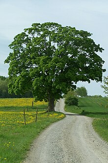
The village linden tree on the Anger, a summer linden tree that is over 200 years old, was declared a natural monument in 1994 .
leisure offers
Kaltenlengsfeld offers a network of hiking trails as well as 20 km of groomed trails in winter.
traffic
Road traffic
The B 285 runs through the neighboring town of Kaltennordheim , 5 km away .
Rail transport
Operation of the Feldabahn was stopped in 2003 and the dismantling of the track system began in 2008. The nearest train stations are now in the district town of Bad Salzungen and to the east in Wasungen - each in the route network of the South Thuringia Railway . There is a connection to the Intercity and ICE network of Deutsche Bahn in Fulda and Eisenach.
Transportation
The following bus lines run by Verkehrsgesellschaft Wartburgkreis mbH run to Kaltenlengsfeld:
| line | Driving distance |
|---|---|
| L-101 | Eisenach - Dermbach - Kaltennordheim - Kaltenlengsfeld |
| L-109 | Bad Salzungen - Dermbach - Kaltennordheim - Kaltenlengsfeld |
| L-129 | Bad Salzungen - Leimbach - Dermbach - Kaltennordheim - Kaltenlengsfeld |
Bus traffic in the Kaltennordheim - Kaltenlengsfeld section is limited to working days.
Individual evidence
- ↑ a b Thuringian State Surveying Office TK25 - sheet 5326 Tann , Erfurt 1999, ISBN 3-86140-090-1
- ^ Geyer, Jahne, Storch: Geological sights of the Wartburg district and the independent city of Eisenach . In: District Office Wartburgkreis, Lower Nature Conservation Authority (Hrsg.): Nature conservation in the Wartburgkreis . Booklet 8. Printing and publishing house Frisch, Eisenach and Bad Salzungen 1999, ISBN 3-9806811-1-4 , p. 174-175 .
- ↑ Robert Riemann Keltenburgen north and south of the Thuringian Forest Hagenberg-Verlag Homburg 1986 p. 26
- ^ Ernst Friedrich Johann Dronke Codex Diplomaticus Fuldensis Kassel 1850 (first printing) 388
- ^ Paul Luther: Materials for local history lessons - Bad Salzungen district, Suhl district . Ed .: Council of the Bad Salzungen District, Department of Public Education. Bad Salzungen 1959, structure of the district of Suhl (overview of the places and population of the districts), p. 5-11 .
- ↑ S. Rost: From the big city plant to the country egg. In: The magazine for the Wartburg region, issue 38, Ruhla 2018, 4–7
- ^ Biedermann: Natural monuments in the Wartburg district; District Office Wartburgkreis, 2014, page 102
- ↑ Thuringian Land Surveying Office TK350 overview map - Thuringia, Erfurt (from 1991)
- ↑ Verkehrsgesellschaft Wartburgkreis mbH - timetable


