
Canton of Juzennecourt
| Former Canton of Juzennecourt |
|
|---|---|
| region | Champagne-Ardenne |
| Department | Haute-Marne |
| Arrondissement | Chaumont |
| main place | Juzennecourt |
| Dissolution date | March 29, 2015 |
| Residents | 2,861 (Jan 1, 2012) |
| Population density | 10 inhabitants / km² |
| surface | 272.67 km² |
| Communities | 15th |
| INSEE code | 5214 |
The canton of Juzennecourt was a French canton in the arrondissement Chaumont in the Haute-Marne department and in the Champagne-Ardenne region until 2015 ; its main town was Juzennecourt . Michel Berthelmot was the representative in the General Council of the department from 1998 to 2011, followed by Stéphane Martinelli until 2015.
geography
The canton of Juzennecourt was in the west of the Haute-Marne department in the north of the Chaumont arrondissement.
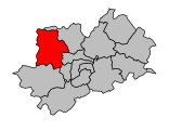
Location of the former canton of Juzennecourt in the Arrondissement of Chaumont.

Communities
The canton consisted of 15 municipalities:
| local community | Population year | Area km² | Population density | Code INSEE | Post Code |
|---|---|---|---|---|---|
| Autreville-sur-la-Renne | 393 (2013) | 41.76 | 9 inhabitants / km² | 52031 | 52120 |
| Blaisy | 76 (2013) | 5.62 | 14 inhabitants / km² | 52053 | 52330 |
| Colombey-les-Deux-Eglises | 665 (2013) | 73.63 | 9 inhabitants / km² | 52140 | 52330 |
| Curmont | 13 (2013) | 2.94 | 4 inhabitants / km² | 52157 | 52330 |
| Gillancourt | 113 (2013) | 15.09 | 7 inhabitants / km² | 52221 | 52330 |
| Juzennecourt | 209 (2013) | 11.87 | 18 inhabitants / km² | 52253 | 52330 |
| Lachapelle-en-Blaisy | 77 (2013) | 16.53 | 5 inhabitants / km² | 52254 | 52330 |
| Lamothe-en-Blaisy | 73 (2013) | 10.21 | 7 inhabitants / km² | 52262 | 52330 |
| Maranville | 431 (2013) | 12.42 | 35 inhabitants / km² | 52308 | 52370 |
| Meures | 128 (2013) | 8.17 | 16 inhabitants / km² | 52322 | 52310 |
| Montheries | 60 (2013) | 16.22 | 4 inhabitants / km² | 52330 | 52330 |
| Rennepont | 153 (2013) | 11.98 | 13 inhabitants / km² | 52419 | 52370 |
| Rizaucourt-Buchey | 119 (2013) | 15.07 | 8 inhabitants / km² | 52426 | 52330 |
| Sexfontaines | 125 (2013) | 20.77 | 6 inhabitants / km² | 52472 | 52330 |
| Vaudrémont | 123 (2013) | 10.39 | 12 inhabitants / km² | 52506 | 52330 |
Population development
| 1962 | 1968 | 1975 | 1982 | 1990 | 1999 | 2006 | 2012 |
|---|---|---|---|---|---|---|---|
| 2,690 | 2,984 | 2,831 | 2,882 | 2,838 | 2,827 | 2,911 | 2,861 |