Lachapelle-en-Blaisy
| Lachapelle-en-Blaisy | ||
|---|---|---|
|
|
||
| region | Grand Est | |
| Department | Haute-Marne | |
| Arrondissement | Chaumont | |
| Canton | Châteauvillain | |
| Community association | Chaumont, Bassin Nogentais et Bassin de Bologne Vignory Froncles | |
| Coordinates | 48 ° 12 ′ N , 4 ° 58 ′ E | |
| height | 270-377 m | |
| surface | 16.53 km 2 | |
| Residents | 81 (January 1, 2017) | |
| Population density | 5 inhabitants / km 2 | |
| Post Code | 52330 | |
| INSEE code | 52254 | |
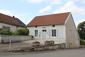
 Mairie Lachapelle-en-Blaisy |
||
Lachapelle-en-Blaisy is a French commune with 81 inhabitants (as of January 1, 2017) in the Haute-Marne department in the Grand Est region . It belongs to the Arrondissement of Chaumont and the canton of Châteauvillain .
location
Lachapelle-en-Blaisy is located on the Blaise River about 67 kilometers east-southeast of Troyes and 16 kilometers west of the small town of Chaumont in the west of the Haute-Marne department.
history
The parish belonged to the Chaumont district from 1793 to 1801. Since 1801 it has been part of the Chaumont arrondissement. From 1793 to 2015 Lachapelle-en-Blaisy was also part of the canton of Juzennecourt .
population
| year | 1793 | 1806 | 1821 | 1841 | 1846 | 1866 | 1911 | 1921 | 1962 | 1968 | 1975 | 1982 | 1990 | 1999 | 2006 | 2012 |
| Residents | 326 | 406 | 381 | 441 | 391 | 387 | 220 | 184 | 136 | 102 | 66 | 75 | 78 | 87 | 80 | 77 |
| Sources: Cassini and INSEE | ||||||||||||||||
Attractions
- Saint-Michel village church from 1780, monument historique
- several wayside crosses
- Memorial to the Fallen
Web links
Commons : Lachapelle-en-Blaisy - Collection of images, videos and audio files
- Brief information about the community
- Lachapelle-en-Blaisy on the IGN side
- Photos of the Saint-Michel village church

