Ninville
| Ninville | ||
|---|---|---|
|
|
||
| region | Grand Est | |
| Department | Haute-Marne | |
| Arrondissement | Chaumont | |
| Canton | Nogent | |
| Community association | Chaumont, Bassin Nogentais et Bassin de Bologne Vignory Froncles | |
| Coordinates | 48 ° 5 ' N , 5 ° 26' E | |
| height | 370–456 m | |
| surface | 9.03 km 2 | |
| Residents | 79 (January 1, 2017) | |
| Population density | 9 inhabitants / km 2 | |
| Post Code | 52800 | |
| INSEE code | 52352 | |
 View of Ninville |
||
Ninville (1793 to 1800 with the spelling Nainville ) is a French commune with 79 inhabitants (as of January 1, 2017) in the Haute-Marne department in the Grand Est region (until 2015 Champagne-Ardenne ). The municipality belongs to the Arrondissement Chaumont and to the municipality association Chaumont, Bassin Nogentais et Bassin de Bologne Vignory Froncles, founded in 2016 . The inhabitants are called ninvillois .
geography
The municipality of Ninville is located in the Bassigny region north of the Langres plateau , 20 kilometers east of Chaumont and about 47 kilometers southwest of Vittel . The community area of 9.03 km² shows a mixture of fields, meadows and smaller wooded areas. Larger forest areas can be found in the northeast ( Bois du Roulet ) and in the south ( Bois de la Pommeraie ). The two streams Ruisseau de la Folle and Ruisseau des Étiquets unite in the village of Ninville to form the Val d'Orsoy , which flows into the Rognon a few kilometers to the northwest . The highest point in the municipality is the 456 m high Mont de Formont in the southeast. Ninville is surrounded by the neighboring communities of Cuves in the north, Buxières-lès-Clefmont in the northeast, Noyers in the east, Rangecourt in the southeast, Is-en-Bassigny in the south, Nogent in the west and Mennouveaux in the northwest.
Population development
| year | 1962 | 1968 | 1975 | 1982 | 1990 | 1999 | 2007 | 2016 |
| Residents | 145 | 138 | 128 | 121 | 114 | 81 | 86 | 85 |
| Sources: Cassini and INSEE | ||||||||
Attractions
- Saint-Martin church, completed in 1772, with a listed altarpiece; inside the church two tombstones from 1559 and 1574
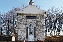
- Funerary chapel of the Coquillard family in the cemetery
- Floor cross
- Lavoir
Economy and Infrastructure
Ten farms are located in the municipality of Ninville (grain cultivation, sheep, goat and cattle breeding).
Ninville is away from the major national traffic flows. It is connected to the neighboring communities by back roads. Twelve kilometers to the south-east there is a connection to the A 31 autoroute from Nancy to Dijon in the municipality of Val-de-Meuse . The train station in Merrey, eleven kilometers to the east, is on the Culmont-Chalindrey-Toul and Merrey-Hymont-Mattaincourt railway lines .
supporting documents
- ↑ toponym on cassini.ehess.fr (French)
- ↑ Ninville on cassini.ehess.fr (French)
- ↑ Ninville on INSEE
- ↑ Ninville at the presentation of the community association (French)
- ↑ Farms on annuaire-mairie.fr (French)

