
Dancevoir
| Dancevoir | ||
|---|---|---|
|
||
| region | Grand Est | |
| Department | Haute-Marne | |
| Arrondissement | Chaumont | |
| Canton | Châteauvillain | |
| Community association | Trois Forêts | |
| Coordinates | 47 ° 56 ' N , 4 ° 53' E | |
| height | 245-349 m | |
| surface | 25.58 km 2 | |
| Residents | 189 (January 1, 2017) | |
| Population density | 7 inhabitants / km 2 | |
| Post Code | 52210 | |
| INSEE code | 52165 | |

Dancevoir is a French commune with 189 inhabitants (as of January 1, 2017) in the Haute-Marne department in the Grand Est region ; it belongs to the arrondissement of Chaumont and the canton of Châteauvillain (until 2015: canton of Arc-en-Barrois ).
geography
Dancevoir is located about 27 kilometers southeast of Chaumont am Aube . Dancevoir is surrounded by the neighboring communities of Latrecy-Ormoy-sur-Aube in the north, Coupray in the northeast, Aubepierre-sur-Aube in the east and southeast, Lignerolles in the south, La Chaume in the south and southwest, Boudreville in the west and Veuxhaulles-sur-Aube in the west and northwest.
| Population development | ||||||||
|---|---|---|---|---|---|---|---|---|
| year | 1962 | 1968 | 1975 | 1982 | 1990 | 1999 | 2006 | 2013 |
| Residents | 325 | 275 | 240 | 226 | 238 | 234 | 251 | 216 |
| Source: Cassini and INSEE | ||||||||
Attractions
- Saint-Pierre-ès-Liens church from the 13th century, a historic monument since 1990
- House Louis from 1564
- lock

church
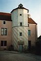
House louis

lock


Web links
Commons : Dancevoir - collection of pictures, videos and audio files