Latrecey-Ormoy-sur-Aube
| Latrecey-Ormoy-sur-Aube | ||
|---|---|---|
|
|
||
| region | Grand Est | |
| Department | Haute-Marne | |
| Arrondissement | Chaumont | |
| Canton | Châteauvillain | |
| Community association | Trois Forêts | |
| Coordinates | 47 ° 59 ′ N , 4 ° 51 ′ E | |
| height | 213-362 m | |
| surface | 46.27 km 2 | |
| Residents | 295 (January 1, 2017) | |
| Population density | 6 inhabitants / km 2 | |
| Post Code | 52120 | |
| INSEE code | 52274 | |
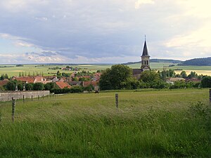
 View of Latrecey |
||
Latrecey-Ormoy-sur-Aube is a French commune with 295 inhabitants (as of January 1, 2017) in the Haute-Marne department in the Grand Est region (until 2015 Champagne-Ardenne ). It belongs to the Arrondissement of Chaumont and the Trois Forêts community association founded in 2003 . The inhabitants are called Latrecéens .
geography
Latrecey-Ormoy-sur-Aube lies on the edge of the Bassigny countryside , about 23 kilometers southwest of Chaumont . The river Aube runs along the western border of the municipality . Latrecey-Ormoy-sur-Aube is surrounded by the neighboring communities of Dinteville in the north and north-west, Châteauvillain in the north and east, Coupray in the east and south-east, Dancevoir and Veuxhaulles-sur-Aube in the south, Montigny-sur-Aube in the south-west, Gevrolles in the West and Lanty-sur-Aube in the north-west.
Population development
| year | 1962 | 1968 | 1975 | 1982 | 1990 | 1999 | 2006 | 2011 | 2016 |
| Residents | 401 | 389 | 436 | 392 | 371 | 339 | 336 | 303 | 290 |
| Source: Cassini and INSEE | |||||||||
Attractions
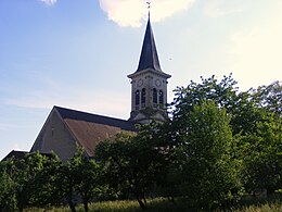
- Saint-Pierre-ès-Liens church from the 18th century, historic monument

