Orquevaux
| Orquevaux | ||
|---|---|---|
|
|
||
| region | Grand Est | |
| Department | Haute-Marne | |
| Arrondissement | Chaumont | |
| Canton | Poissons | |
| Community association | Meuse Rognon | |
| Coordinates | 48 ° 18 ' N , 5 ° 24' E | |
| height | 291-427 m | |
| surface | 15.70 km 2 | |
| Residents | 80 (January 1, 2017) | |
| Population density | 5 inhabitants / km 2 | |
| Post Code | 52700 | |
| INSEE code | 52369 | |
Orquevaux is a French commune with 80 inhabitants (as of January 1, 2017) in the Haute-Marne department in the Grand Est region (until 2015 Champagne-Ardenne ). The municipality belongs to the Arrondissement Chaumont and the municipality association Meuse Rognon, founded in 2017 . The inhabitants are called Orquevoux, Orquevouses, Orcivaliens or Orcivaliennes .
geography
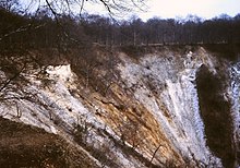
The municipality of Orquevaux is located on the northern edge of the Langres plateau , about 25 kilometers southwest of Neufchâteau and 30 kilometers northeast of Chaumont . The municipal area of 15.7 km² is three-quarters covered with forest ( Le Retondu, Bois de Châtelmont, Châté ). Areas in the north-west and north-east of the municipality are partially free of forests above 400 m. The 100 m deep gorges of the river Manoise and two tributaries are characteristic of the municipality . The Manoise drains over the Sueurre and the Rognon to the Marne . The source of the Manoise is at the end of a crater-like ravine called Cul du Cerf . This Reculée is a rare geological phenomenon and is particularly common in the Jura , 150 kilometers southeast . In addition to the village of Orquevaux, the municipality includes the hamlets of Le Fourneau, Fleuret and Ferme de Champaumont . Orquevaux is surrounded by the neighboring communities of Leurville in the north, Aillianville in the northeast, Vesaignes-sous-Lafauche in the east, Saint-Blin in the south, Humberville in the west and Reynel in the north-west.
Population development
| year | 1962 | 1968 | 1975 | 1982 | 1990 | 1999 | 2009 | 2016 |
| Residents | 140 | 135 | 106 | 93 | 75 | 92 | 82 | 86 |
| Sources: Cassini and INSEE | ||||||||
Attractions
- Saint-André church
- Château d'Orquevaux
- Lavoir
- Reculée Cul du Cerf / Source of the Manoise, designated as a Natura 2000 protected area
- Floor cross
Economy and Infrastructure
There are three farms in the municipality of Orquevaux (cereal cultivation, cattle breeding).
Orquevaux is away from the major national traffic flows. The parish is connected by roads to Aillianville , Humberville, and Leurville . In the municipality of Saint-Blin , located five kilometers to the south, there is a connection to the former Route nationale 427 (today's D674) from Neufchâteau to Chaumont . There is a motorway connection to the A31 autoroute 33 kilometers south-east in Vrécourt .
supporting documents
- ↑ Orquevaux on cassini.ehess.fr (French)
- ↑ Orquevaux on INSEE
- ↑ Farms on annuaire-mairie.fr (French)

