
Illoud
| Illoud | ||
|---|---|---|
|
||
| region | Grand Est | |
| Department | Haute-Marne | |
| Arrondissement | Chaumont | |
| Canton | Poissons | |
| Community association | Meuse Rognon | |
| Coordinates | 48 ° 13 ' N , 5 ° 34' E | |
| height | 309-466 m | |
| surface | 13.85 km 2 | |
| Residents | 220 (January 1, 2017) | |
| Population density | 16 inhabitants / km 2 | |
| Post Code | 52150 | |
| INSEE code | 52247 | |
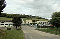
 Town Hall (maison commune) |
||

Illoud ( Illoud ) is a French commune with 220 inhabitants (as of January 1, 2017) in the Haute-Marne department in the Grand Est region (until 2015 Champagne-Ardenne ). The municipality belongs to the arrondissement of Chaumont and is the administrative seat of the municipality association Meuse Rognon, founded in 2017 (between 2012 and 2016 Illoud was also the seat of the predecessor association Bourmont, Breuvannes, Saint-Blin ). The inhabitants are called Illoudiens .
geography
The municipality of Illoud is located in the Bassigny landscape on the northeastern edge of the Langres plateau in a side valley of the upper Meuse , about 22 kilometers southwest of Neufchâteau and 40 kilometers northeast of Chaumont . The 13.85 km² community area is characterized by a mixture of forests on the mountain slopes, fields on the higher plateaus and pastures and meadows in the valley. In the west, the municipality has a share in the large Bois de Chalvraines forest . The districts of La Fortelle and Beaucharmoi belong to the municipality of Illoud . Illoud is surrounded by the neighboring communities of Goncourt in the northeast, Bourmont-entre-Meuse-et-Mouzon and Saint-Thiébault in the east, Bourg-Sainte-Marie in the south, Romain-sur-Meuse in the southwest and Chalvraines in the west.
Place name

When the church was founded in 1793, the place was already called Illoud ; for a short time around 1801 Ilond-la-Fortelle . Since then, the notation Illoud , which is still used today, has been used .
Population development
| year | 1962 | 1968 | 1975 | 1982 | 1990 | 1999 | 2006 | 2016 | |
| Residents | 170 | 200 | 313 | 382 | 354 | 322 | 303 | 227 | |
| Sources: Cassini and INSEE | |||||||||
Attractions
- Saint Martin Church
- numerous fountains
- Church of St. Martin in Illoud


Economy and Infrastructure
Illoud is characterized by agriculture. There are five farms in the municipality (cereal cultivation, cattle breeding).
One of the three large industrial cheese dairies (fromagerie) operated by Savencia Fromage & Dairy (formerly Bongrain ) is located in Illoud . The “ Caprice des Dieux ” brand has been produced here since 1956 .
Savencia Fromage & Dairy, formerly Bongrain

La Divine cheese factory
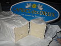
"Caprice des Dieux"


The D16 départemental road runs through Illoud from Saint-Blin to Saint-Thiébault in the Meuse Valley . There is a connection to the A31 autoroute 17 kilometers southeast of Illoud .
supporting documents
- ↑ toponym on cassini.ehess.fr (French)
- ↑ Illoud on cassini.ehess.fr
- ↑ Illoud on insee.fr
- ↑ Farms on annuaire-mairie.fr (French)
- ↑ Caprice des Dieux (French)