Huilliécourt
| Huilliécourt | ||
|---|---|---|
|
|
||
| region | Grand Est | |
| Department | Haute-Marne | |
| Arrondissement | Chaumont | |
| Canton | Poissons | |
| Community association | Meuse Rognon | |
| Coordinates | 48 ° 10 ′ N , 5 ° 33 ′ E | |
| height | 311-489 m | |
| surface | 8.87 km 2 | |
| Residents | 118 (January 1, 2017) | |
| Population density | 13 inhabitants / km 2 | |
| Post Code | 52150 | |
| INSEE code | 52243 | |
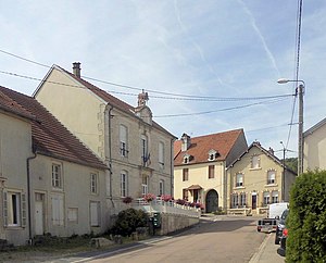
 Mairie Huilliécourt |
||
Huilliécourt (at the end of the 18th century still with the spellings Huillecourt and Huillécourt ) is a French commune with 118 inhabitants (as of January 1, 2017) in the Haute-Marne department in the Grand Est region (until 2015 Champagne-Ardenne ). The municipality belongs to the Arrondissement Chaumont and the municipality association Meuse Rognon, founded in 2017 . The inhabitants are called Huilliécourtois .
geography
The municipality of Huilliécourt is located in the Bassigny countryside on the northeastern edge of the Langres plateau on the upper Meuse , about halfway between the towns of Chaumont and Vittel . The municipal area of 8.87 km² is divided into two parts: in the east, meadows and fields define the flat landscape up to the left bank of the Maas; a striking steep step leads in the west of the municipality to a high plateau 120 meters above the Meuse valley, which is extensively forested and reaches the highest point at 489 m in the northwest. Huilliécourt is surrounded by the neighboring communities of Romain-sur-Meuse in the north, Bourg-Sainte-Marie and Hâcourt in the northeast, Doncourt-sur-Meuse in the east, Levécourt in the southeast, Vroncourt-la-Côte in the south, Thol-lès-Millières in the Southwest and Ozières in the west.
Population development
| year | 1962 | 1968 | 1975 | 1982 | 1990 | 1999 | 2007 | 2016 |
| Residents | 195 | 176 | 164 | 158 | 147 | 143 | 133 | 118 |
| Sources: Cassini and INSEE | ||||||||
Attractions
- Saint Martin Church
Economy and Infrastructure
Huilliécourt has a rural character. There are three farms in the municipality (sheep, goat and poultry breeding).
Huilliécourt is away from the major national traffic flows. The D74 (former Route nationale 74 ) leads through the municipality from Neufchâteau to Langres . There is a connection to the A31 autoroute 13 kilometers east of Huilliécourt . On the opposite, eastern bank of the Meuse, the Culmont-Chalindrey-Toul railway runs without stopping in the vicinity.
supporting documents
- ↑ toponym on cassini.ehess.fr
- ↑ Huilliécourt on cassini.ehess.fr (French)
- ↑ Huilliécourt on INSEE
- ↑ Farms on annuaire-mairie.fr (French)

