
Graffigny-Chemin
| Graffigny-Chemin | ||
|---|---|---|
|
||
| region | Grand Est | |
| Department | Haute-Marne | |
| Arrondissement | Chaumont | |
| Canton | Poissons | |
| Community association | Communauté de communes de Bourmont, Breuvannes, Saint-Blin | |
| Coordinates | 48 ° 10 ' N , 5 ° 38' E | |
| height | 322-500 m | |
| surface | 17.27 km 2 | |
| Residents | 232 (January 1, 2017) | |
| Population density | 13 inhabitants / km 2 | |
| Post Code | 52150 | |
| INSEE code | 52227 | |
 Mairie Graffigny-Chemin |
||

Graffigny-Chemin is a French commune with 232 inhabitants (as of January 1, 2017) in the Haute-Marne department in the Grand Est region . It belongs to the Arrondissement of Chaumont and the canton of Poissons .
Neighboring municipalities are Bourmont-entre-Meuse-et-Mouzon with Bourmont in the north, Soulaucourt-sur-Mouzon in the northeast, Vrécourt in the east, Robécourt in the southeast, Chaumont-la-Ville in the south, Doncourt-sur-Meuse , Hâcourt and Malaincourt- sur-Meuse in the southwest and Brainville-sur-Meuse in the west.
Population development
| year | 1962 | 1968 | 1975 | 1982 | 1990 | 1999 | 2008 | 2016 |
|---|---|---|---|---|---|---|---|---|
| Residents | 394 | 370 | 329 | 319 | 273 | 212 | 230 | 231 |
| Source: Cassini and INSEE | ||||||||
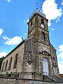
Saint-Élophe-Saint-Christophe church in Graffigny

Saint-Nicolas church in Chemin

Graffigny-Chemin school


Web links
Commons : Graffigny-Chemin - collection of images, videos and audio files