
Ormoy-lès-Sexfontaines
| Ormoy-lès-Sexfontaines | ||
|---|---|---|
|
||
| region | Grand Est | |
| Department | Haute-Marne | |
| Arrondissement | Chaumont | |
| Canton | Bologne | |
| Community association | Chaumont, Bassin Nogentais et Bassin de Bologne Vignory Froncles | |
| Coordinates | 48 ° 13 ' N , 5 ° 5' E | |
| height | 274-368 m | |
| surface | 5.53 km 2 | |
| Residents | 43 (January 1, 2017) | |
| Population density | 8 inhabitants / km 2 | |
| Post Code | 52310 | |
| INSEE code | 52367 | |
 Entrance |
||

Ormoy-lès-Sexfontaines is a French commune with 43 inhabitants (as of January 1, 2017) in the Haute-Marne department in the Grand Est region (until 2015 Champagne-Ardenne ). It belongs to the Arrondissement Chaumont and the municipality association Chaumont, Bassin Nogentais et Bassin de Bologne Vignory Froncles .
The name affix -lès-Sexfontaines (near Sexfontaines ) was given to the community in 1801 to better distinguish it from several other communities of the same name .
geography

The municipality is located between the Barrois landscapes in the north and the Langres plateau in the south, around 15 kilometers north of the departmental capital Chaumont . The 5.53 km² area of the municipality is shaped by forest in the north (part of the 30 km² Forêt de l'Étoile ), in the south there is arable land. In the village of Ormoy, the small Marne tributary Ruisseau d'Oudincourt has its source in a stone spring .
Neighboring municipalities to Ormoy-lès-Sexfontaines (clockwise, starting from the north) are: Soncourt-sur-Marne , Oudincourt , Annéville-la-Prairie , Meures and Sexfontaines .
Residents
| year | 1962 | 1968 | 1975 | 1982 | 1990 | 1999 | 2007 | 2016 |
|---|---|---|---|---|---|---|---|---|
| Residents | 65 | 93 | 78 | 56 | 53 | 50 | 42 | 45 |
| Sources: Cassini and INSEE | ||||||||
Attractions
- Church of Our Lady and Her Birth ( Église Notre-Dame-en-sa-Nativité )
- Fallen memorial
- Floor cross

Notre-Dame-en-sa-Nativité church

Mairie Ormoy-lès-Sexfontaines
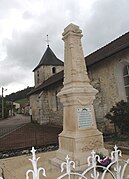
Fallen memorial


Economy and Infrastructure
Ormoy-lès-Sexfontaines is dominated by agriculture. Ten agricultural businesses are located in the municipality (grain cultivation, cattle breeding).
Ormoy-lès-Sexfontaines is connected by roads to the communes of Oudincourt , Annéville-la-Prairie and Sexfontaines . Six kilometers to the east there is a connection to the Route nationale 67, which is partially developed like a motorway . The train station in Bologne, eight kilometers away, is on the Blesme-Haussignémont-Chaumont railway line .
supporting documents
- ↑ toponym on cassini.ehess.fr
- ↑ Ormoy-lès-Sexfontaines on cassini-ehess-fr
- ↑ Ormoy-lès-Sexfontaines on insee.fr
- ↑ Farms on annuaire-mairie.fr (French)