
Aubepierre-sur-Aube
| Aubepierre-sur-Aube | ||
|---|---|---|

|
|
|
| region | Grand Est | |
| Department | Haute-Marne | |
| Arrondissement | Chaumont | |
| Canton | Châteauvillain | |
| Community association | Trois Forêts | |
| Coordinates | 47 ° 55 ' N , 4 ° 56' E | |
| height | 262-398 m | |
| surface | 43.1 km 2 | |
| Residents | 188 (January 1, 2017) | |
| Population density | 4 inhabitants / km 2 | |
| Post Code | 52210 | |
| INSEE code | 52022 | |

Aubepierre-sur-Aube is a French commune with 188 inhabitants (as of January 1, 2017) in the Haute-Marne department in the Grand Est region ; it belongs to the arrondissement of Chaumont and the canton of Châteauvillain (until 2015: canton of Arc-en-Barrois ).
geography
Aubepierre-sur-Aube is located about 26 kilometers south-southeast of Chaumont on the banks of the river Aube . Aubepierre-sur-Aube is surrounded by the neighboring communities Coupray in the north, Cour-l'Évêque in the north and northeast, Arc-en-Barrois in the east and northeast, Giey-sur-Aujon in the east and southeast, Rouvres-sur-Aube in the South and southeast, Gurgy-la-Ville in the south, Les Goulles in the southwest, Lignerolles in the west and Dancevoir in the northwest.
history
Between 1972 and 1982 Aubepierre-sur-Aube was part of the municipality of Arc-en-Barrois.
| Population development | ||||||||
|---|---|---|---|---|---|---|---|---|
| year | 1962 | 1968 | 1975 | 1982 | 1990 | 1999 | 2006 | 2013 |
| Residents | 346 | 296 | 225 | 198 | 195 | 215 | 208 | 187 |
| Source: Cassini and INSEE | ||||||||
Attractions
- Ascension Church
- Longuay Cistercian monastery , founded in 1102/1150, dissolved in 1791
- Longuay Castle, built around 1830 on the monastery grounds

Converse building or tithe barn of the Longuay Monastery
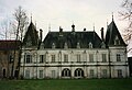
Longuay Castle


Personalities
- Jean Baptiste François Bulliard (1752–1793), doctor and botanist