Juzennecourt
| Juzennecourt | ||
|---|---|---|

|
|
|
| region | Grand Est | |
| Department | Haute-Marne | |
| Arrondissement | Chaumont | |
| Canton | Châteauvillain | |
| Community association | Chaumont, Bassin Nogentais et Bassin de Bologne Vignory Froncles | |
| Coordinates | 48 ° 11 ′ N , 4 ° 59 ′ E | |
| height | 295-391 m | |
| surface | 11.87 km 2 | |
| Residents | 213 (January 1, 2017) | |
| Population density | 18 inhabitants / km 2 | |
| Post Code | 52330 | |
| INSEE code | 52253 | |
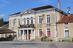
 Mairie Juzennecourt |
||
Juzennecourt is a French commune with 213 inhabitants (as of January 1, 2017) in the Haute-Marne department in the Grand Est region . It belongs to the Arrondissement of Chaumont and the canton of Châteauvillain . The inhabitants are called Juzennecourtois (es) .
location
Juzennecourt is located on the Blaise River about 68 kilometers east-southeast of Troyes and 14 kilometers northwest of the small town of Chaumont in the west of the Haute-Marne department.
Transport links
The community is on the D619 from Chaumont to Troyes. Via this one reaches the Route nationale 67 in a south-easterly direction 14 kilometers away near Chaumont .
history
The parish belonged to the Chaumont district from 1793 to 1801. Since 1801 it has been part of the Chaumont arrondissement. From 1793 to 2015, Juzennecourt was the capital of the canton of Juzennecourt .
population
| year | 1793 | 1800 | 1851 | 1856 | 1866 | 1891 | 1921 | 1954 | 1962 | 1968 | 1975 | 1982 | 1990 | 1999 | 2006 | 2012 |
| Residents | 264 | 243 | 404 | 347 | 341 | 303 | 212 | 252 | 181 | 193 | 154 | 135 | 148 | 177 | 205 | 214 |
| Sources: Cassini and INSEE | ||||||||||||||||
Attractions
- Castle Château de Juzennecourt , built in 1717, since 2001 a monument historique
- Sainte-Madeleine village church from 1806
- several wayside crosses
- Memorial to the Fallen
Web links
- Brief information about the community
- Juzennecourt on the IGN website
- Photos of the village church of Sainte-Madeleine


