Msida
| coat of arms | map |
|---|---|

|
|
| Basic data | |
| State : | Malta |
| Gzejjer : | Malta Majjistral (Northwest Malta) |
| Distretti : | Northern Harbor |
| Area : | 1,699,707 km² |
| Residents : | 13,713 (December 31, 2018) |
| Population density : | 8068 inhabitants / km² |
| ISO 3166-2 : | MT-34 |
| Postal code : | MSD |
| Website : | www.msidalocalcouncil.com |
| politics | |
| Mayor : | Clifton Grima ( MLP ) |
Coordinates: 35 ° 54 ' N , 14 ° 29' E
Msida (or L-Imsida ) is a port city in the northeast of the island of Malta . Although it is quite small, it is one of the most important cities in Malta .
history
Her name is derived from an Arabic term that means something like "a fisherman's place of residence" in German. However, the name could also be derived from the Maltese term "Omm Sidna" (English: Mother of God), as there used to be a small Lady Chapel at this point.
Msida used to be a small fishing village. Today it is urbanized but there are still some fishermen there.
Msida became its own parish in 1867. The settlement developed around a few huts inland on today's Valley Road and a few small streets and paths that led up to the Villambrosa area. This situation did not last long, however, as the new parish of Ħamrun was split off in 1881 . Today Villambrosa Street is a silent reminder of Msida's judicial law in the area. As a result, Msida lost more areas to new communities, such as Santa Venera in 1918 , Pietà in 1968 and Ta 'Xbiex in 1969 .
The population of Msida, which at the best of times had already been 11,000, sank again to 6,000. Since then, the population has increased again to 7,600 - especially due to the construction of new settlements in the outskirts of Swatar. Swatar is also home to St. Martin's College, a leading private secondary school.
National nature
The lower part of Msida lies at the exit of a flat dry valley and is a concentration point for traffic to Sliema , Valletta , Birkirkara and St. Luke's Hospital. In Msida you will also find an old rock chapel, which is dedicated to the Immaculate Conception and is a rarity of its kind.
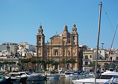
Msida has to contend with flooding from the sea - especially in winter - as the city center and the surrounding areas are partly below sea level. A new project to collect rainwater should alleviate the annual flooding problem in Msida and neighboring cities. When it rains, water from higher lying areas collects in the dry valley and falls through Msida into the sea. This often causes flooding in the area opposite the parish church of St. Joseph, which used to hinder road traffic. A few years ago, the street in the harbor was therefore about 0.5 m higher.
University of Malta
The University of Malta is located in the Tal-Qroqq district in the western part of Msida above the city center. Msida also owns the Giovanni Francesco Abela Junior College and a government nursing home.
hospital
The new hospital in Malta, the "Mater Dei Hospital" , was built on the outskirts of Msida and opened on June 29, 2007. On a floor area of more than 250,000 m², 906 beds and 25 operating theaters are accommodated in over 7000 rooms. Lecture halls for the University of Malta are also included.
The originally planned construction costs amounted to around 116 million euros and rose to around 582 million euros by the time it was completed, which was delayed by three years. Because of the bad management, it was already at the center of political discussions during the construction period. This hospital was originally planned by the conservative government ( PN ) as a special clinic, but was rededicated as a central hospital when the Labor Party took over government .
The Msida Marina
In the late 19th century a dry dock for the British Navy was to be built in the center of the port of Msida, near the former torpedo depot. This plan was soon abandoned, instead a popular marina was built here in later years, which has grown steadily since then due to the corresponding government incentives.
Although this port is called “Marina Msida”, many of the jetties and quays extend beyond Msida into the neighboring towns of Pietà , Ta 'Xbiex and Gżira .
Culture
Msida celebrates the traditional feast of St. Joseph on the first Sunday in July, although his feast day is March 19th. The local football club, Msida St. Joseph FC , plays in the Maltese Premier League .
Sons and daughters
- John Rizzo Naudi (* 1925), doctor, university professor and politician
Web links
Individual evidence
- ↑ StatDB of the National Statistics Office Malta , accessed on August 1, 2020
- ^ Malta health-care: Mater Dei Hospital


