
Campiglia Marittima
| Campiglia Marittima | ||
|---|---|---|

|
|
|
| Country | Italy | |
| region | Tuscany | |
| province | Livorno (LI) | |
| Coordinates | 43 ° 4 ' N , 10 ° 37' E | |
| height | 231 m slm | |
| surface | 83 km² | |
| Residents | 12,789 (Dec. 31, 2019) | |
| Population density | 154 inhabitants / km² | |
| Post Code | 57021 | |
| prefix | 0565 | |
| ISTAT number | 049002 | |
| Popular name | Campigliesi | |
| Patron saint | San Fiorenzo di Populonia (May 15) | |
| Website | Campiglia Marittima | |
 Panorama of Campiglia Marittima |
||

Campiglia Marittima is an Italian municipality in the province of Livorno in the Tuscany region with 12,789 inhabitants (as of December 31, 2019).
Naming
The name Campiglia is derived from the Latin word campus ( Italian campo , field ). Campiglia received the addition ( Italian Marittima , near the sea ) in 1862 on the occasion of the opening of its train station the following year, in order to distinguish the place from other places of the same name (with correspondingly different additions).
geography
The municipality has an area of 83 km². It resembles a triangle that widens from north to south. From the northernmost point, not far from the summit of Monte Calvi (646 m above sea level) to the southernmost point, which approaches the Gulf of Follonica up to 3 kilometers , it measures 12 kilometers. It is 14.5 kilometers from the easternmost point, which protrudes like a finger into the Montioni Natural Park ( Parco interprovinciale di Montioni ), to the westernmost point, which approaches the Etruscan Riviera within 1.5 kilometers.
The northern part of the municipality lies on a foothill of the Tuscan Ore Mountains ( Colline Metallifere ), the middle and southern part in the Cornia plain ( Val di Cornia ). The river Cornia crosses the municipality in the east and south-east.
The municipality of Campiglia Marittima consists of the main town of the same name and the districts Venturina, Cafaggio, Banditelle and Lumiere.
The neighboring municipalities are San Vincenzo (in the northwest and west), Suvereto (in the east) and Piombino (in the southwest and south).
In the rural areas of the municipality there are numerous farms that produce olive oil and wine from their own cultivation, as well as other regional products. A number of homesteads also offer farm holidays .
Campiglia Marittima (main town)
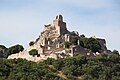
Campiglia Marittima, first mentioned in documents in 1004, is located on a hill dominating the surrounding area. The intact medieval town center with its city wall, the steep, winding streets and rustic house passages as well as the mostly unplastered house facades is one of the most beautiful historical towns on the Etruscan coast . The tree-shaped street and alley network has grown largely naturally and takes into account the cramped topographical conditions on the hilltop. From the ruins of the hilltop castle (11th - 13th centuries) at the highest point of the old town (215 m above sea level) there is a panoramic view of the Gulf of Follonica (in the south) and the Gulf of Baratti (in the southwest; sometimes up to 100 Kilometers away from the island of Corsica ) as well as in the hilly hinterland, rugged by quarries (especially in the north). Evidence of Etruscan, Roman and medieval cultures can be found in the municipality of Campiglia Marittima. The local history collection in the former arms tower of the hilltop castle of Campiglia provides an overview .
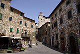
View from Piazza Repubblica to Palazzo Pretorio (with clock tower)
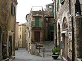
In the old City

In the old City

Ruins of the hilltop castle (Rocca di Campiglia)
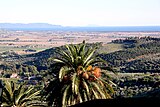
View from Campiglia over the Cornia plain to the Gulf of Follonica
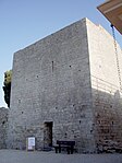
The castle's gun tower with museum

Pieve di San Giovanni (11th century, inside with Sator square ) in the cemetery of Campiglia (Cimitero Monumentale)


Venturina

Venturina with its townscape shaped by the 20th century is located 4.5 kilometers by road southwest of Campiglia on the historic route of the Via Aurelia . This runs straight through the place from northwest to southeast. Venturina (15 m above sea level), located in the open plain, was largely laid out according to plan since the middle of the 19th century . The small town with its approx. 9000 inhabitants forms the residential and economic center of the municipality of Campiglia Marittima. In the north of Venturina there is a small, natural thermal lake with a temperature of 36 ° C. It was already known to the Etruscans ( Caldana ), but there is evidence that it was only used by the Romans ( Aquae Populoniae ).
San Silvestro Archaeological Mining Park
The Archaeological Mining Park of San Silvestro (Parco Archeominerario di San Silvestro) is of supraregional importance. Lead, silver, copper and zinc have been mined on the 450 hectare site in the hills north of Campiglia from the Etruscan period to 1976. The mining park was opened to visitors in 1996 and was added to the list of UNESCO- sponsored geoparks in 2010 . In the middle rises the miners and metal smelters castle Rocca San Silvestro (10th / 11th - 14th centuries).

San Silvestro Archaeological Mining Park

Decommissioned headframe

Mine railway for visitors
Rocca San Silvestro


Dog "Lampo"

In August 1953, a mixed breed dog of unknown origin jumped out of a freight train at the “Campiglia Marittima” train station and moved into quarters at the station. For the next eight years he chose Campiglia as the base for his train journeys all over Italy. He knew the train connections even better than the station master. In 1958, the Italian Broadcasting Corporation made the documentary Lampo, the Traveling Dog , making the dog a celebrity in Italy and beyond. At the time, Lampo was one of the most photographed dogs in the world. His name Lampo (Eng. "Lightning"), which the railway workers of Campiglia gave him, comes from the fact that it appeared in their lives like a bolt of lightning out of the blue. On July 22, 1961, Lampo was run over by a train and buried in front of an acacia tree on the station premises. In 1962, a larger than life statue of Lampo was erected on the station grounds, which can still be seen today. Lampo's closest human reference person, the railroad worker Elvio Barlettani, created a literary monument for him with the book Lampo goes wherever he wants (original title: Lampo, il cane viaggiatore , 1962). In 1967 a book by the Polish writer Roman Pisarski was published, in which the main hero was Lampo, About the dog that drove the train (original title: O psie, który jeździł koleją ).
traffic
Via the state road 1 ( SS 1 Via Aurelia ), which leads past Venturina to the west and south, and the “Campiglia Marittima” train station southwest of Venturina, the community is connected to long-distance traffic with Pisa and Rome .
literature
- Emanuele Repetti: Dizionario Geografico Fisico Storico della Toscana Online edition of the University of Siena on the municipality of Campiglia Marittima.
- Touring Club Italiano : Toscana. Milan 2003, ISBN 88-365-2767-1 , p. 424 f.
Web links
- Official website of the Archaeological Mining Park of San Silvestro (Italian / English)
Notes and individual references
- ↑ Statistiche demografiche ISTAT. Monthly population statistics of the Istituto Nazionale di Statistica , as of December 31 of 2019.
- ↑ From there it is 5 kilometers to the west as the crow flies and 7 kilometers to the south to the sea.
- ↑ Alternative spelling: San Silvestro Mining Archaeological Park
- ↑ The best from Readers Digest, issue 04/1981
- ↑ Daniel Hörnemann: Lampo - the railway (er) dog . ( bahnhof-lette.de [PDF]).
- ↑ Overdogs . In: The time . No. 11/1964 ( zeit.de ).

Bibbona |
Campiglia Marittima |
Castagneto Carducci |
Cecina |
Collesalvetti |
Livorno |
Piombino |
Rosignano Marittimo |
San Vincenzo |
Sassetta |
Suvereto
on the island of Elba :
Campo nell'Elba |
Capoliveri |
Marciana |
Marciana Marina |
Porto Azzurro |
Portoferraio |
Rio
On the island of Capraia :
Capraia Isola