Layton (Florida)
| Layton | |
|---|---|
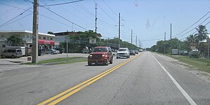
 Downtown with the Overseas Highway |
|
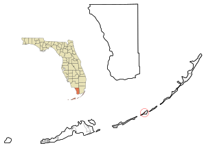
| County and state location | |
| Basic data | |
| Foundation : | 1963 |
| State : | United States |
| State : | Florida |
| County : | Monroe County |
| Coordinates : | 24 ° 50 ′ N , 80 ° 49 ′ W |
| Time zone : | Eastern ( UTC − 5 / −4 ) |
| Residents : | 184 (as of 2010) |
| Population density : | 328.6 inhabitants per km 2 |
| Area : | 0.63 km 2 (approx. 0 mi 2 ) of which 0.56 km 2 (approx. 0 mi 2 ) is land |
| Height : | 1 m |
| Postal code : | 33001 |
| Area code : | +1 305 |
| FIPS : | 12-39725 |
| GNIS ID : | 2404899 |
| Website : | www.cityoflayton.com |
| Mayor : | Norman Anderson |
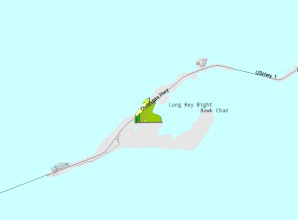
 Location of Layton on Long Key |
|
Layton is a city in Monroe County in the US state of Florida with 184 inhabitants (as of 2010).
geography
The city is located on Long Key Island , which is part of the Florida Keys . It is located on the Overseas Highway ( US 1 , SR 5 ) and is approximately 100 km from Key West and 140 km from Miami .
history
Mary and Del Layton , a grocer couple from Miami , bought 16 hectares of property on Long Key after World War II and set up a fishing camp there. Little by little, they expanded what was known as Layton's Long Key Fishing Camp to include cabins and a restaurant. On September 18, 1963, the plant went on in the newly founded town of Layton.
Demographic data
According to the 2010 census, the 184 inhabitants at that time were distributed over 184 households. The population density was 328.6 inh / km². 92.9% of the population identified themselves as whites, 2.2% as African American , 1.6% as Indians and 2.2% as Asian Americans . 1.1% said they belonged to several ethnic groups. 7.1% of the population was made up of Hispanics or Latinos .
In 2010 children under 18 years of age and 40.2% of all households lived in 7.2% of all households with persons at least 65 years of age. 54.6% of households were family households (consisting of married couples with or without offspring or one parent with offspring). The average household size was 1.90 people and the average family size was 2.25 people.
7.6% of the population were younger than 20 years old, 14.1% were 20 to 39 years old, 33.7% were 40 to 59 years old, and 44.6% were at least 60 years old. The mean age was 57 years. 52.2% of the population were male and 47.8% were female.
The median annual income was $ 52,292, with 3.3% of the population living below the poverty line.
In 2000, English was the first language of 90.69% of the population and Spanish was spoken by 9.31%.
Attractions
The following properties are listed on the National Register of Historic Places :
- Angustias Shipwreck Site
- El Gallo Indiano Shipwreck Site
- San Francisco Shipwreck Site
- Sueco de Arizon Shipwreck Site
All four shipwrecks are part of the 1733 Spanish Plate Fleet Shipwrecks Multiple Property Submission ( MPS )
economy
Layton lives mainly from tourism. The city is surrounded by Long Key State Park with a popular campground.
In town is the JN Roth Marine Biology Station , a branch of Goshen College in Goshen , Indiana . The station's current building was erected in 1985.
Web links
- Website of the city (Engl.)
- Jerry Wilkinson: History of Long Key (Engl.)
Individual evidence
- ^ Profile of General Population and Housing Characteristics: 2010 . United States Census Bureau . Retrieved April 3, 2013.
- ↑ Language distribution 2000 . Modern Language Association . Retrieved April 3, 2013.
- ↑ FLORIDA - Monroe County. National Register of Historic Places , accessed July 28, 2015 .
- ^ JN Roth Marine Biology Station. (No longer available online.) Archived from the original on February 6, 2013 ; accessed on January 28, 2013 . Info: The archive link was inserted automatically and has not yet been checked. Please check the original and archive link according to the instructions and then remove this notice.

