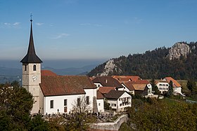
Saint-Brais
| Saint-Brais | |
|---|---|
| State : |
|
| Canton : |
|
| District : | Franches-Montagnes |
| BFS no. : | 6758 |
| Postal code : | 2364 |
| Coordinates : | 575 444 / 239614 |
| Height : | 967 m above sea level M. |
| Height range : | 443-1058 m above sea level M. |
| Area : | 15.16 km² |
| Residents: | 220 (December 31, 2018) |
| Population density : | 15 inhabitants per km² |
|
Saint-Brais |
|
| Location of the municipality | |
Saint-Brais is a municipality in the Franches-Montagnes district in the canton of Jura in Switzerland . The former German name Sankt Brix is no longer used today.
geography
Saint-Brais is 967 m above sea level. M. , ten kilometers northeast of the district capital Saignelégier ( linear distance ). The village extends on a promising Jura ridge of northeastern Freiberge (French Freiberge ), at the edge of the deep valley of the Doubs .
The area of the municipal area of 15.2 km² covers part of the northernmost Jura ridge of the Freiberg Mountains, which merges into the Mont-Russelin chain to the northeast. This ridge is characterized by extensive Jura meadows with large spruce trees standing individually or in groups and forest areas in between. At the level of Le Plain west of the village is 1057 m above sea level. M. reached the highest point of Saint-Brais. To the south, the municipality extends into the erosion valley of the Tabeillon stream , a left side stream of the Sorne . In this valley lies the Bollemont pond, which is under conservation . To the north, the area extends to the course of the Doubs and includes its 500 m high right valley flank with extensive forests, which are criss-crossed by a few rock bands. Saint-Brais is therefore on the watershed between the catchment areas of the Rhine and Rhone . In 1997, 3% of the municipal area was in settlements, 45% in forests and woodlands, 50% in agriculture and a little less than 2% was unproductive land.
Saint-Brais includes the district of Le Péquie ( 995 m above sea level ) on the eastern ledge of the Plain, the hamlet of Le Chésal ( 940 m above sea level ) east of the village as well as numerous individual farms scattered far across the Jura meadows . The neighboring municipalities of Saint-Brais are Lajoux , Montfaucon , Clos du Doubs , Glovelier and Saulcy .
population
With 220 inhabitants (as of December 31, 2018), Saint-Brais is one of the small communities in the canton of Jura. 88.7% of the residents are French-speaking, 8.5% German-speaking and 1.9% speak Dutch (as of 2000). The population of Saint-Brais was 562 in 1870, compared to 394 in 1900. In the course of the 20th century, a further decrease of more than 40% was registered as a result of strong emigration.
economy
Saint-Brais is a still heavily agricultural village with dairy farming and cattle breeding . Outside the primary sector there are relatively few jobs in the village in local small businesses. Many workers are therefore commuters and work away from home, either in Saignelégier or in the Delémont region .
The Saint-Brais wind farm has existed since 2009 .
traffic
The municipality is located on the main road from Delémont to La Chaux-de-Fonds , on which the bus route from Glovelier to Saignelégier also runs. On May 21, 1904, the railway line of the Régional Saignelégier-Glovelier , a predecessor of the Chemins de fer du Jura , opened with a train station in the Tabeillon valley. Actually, it is not a train station, just a stop called Bollement.
history
The discovery of a bone from the Paleolithic and an incisor of a Neanderthal man in the caves of Saint-Brais below the striking rock face 1 km northeast of Saint-Brais prove that the area was settled in prehistoric times.
The village is first mentioned in 1275 as Sem Bris . Later names are Saint-Brey (1318) and de Sancto Brixio (1380). The origin of the place name is controversial, Saint-Brais goes back either to Saint Brice , a companion of St. Imier, or to Brictius , the bishop of Tours . Saint-Brais belonged to the dominion of Freiberge, which was under the principality of Basel . From 1793 to 1815 the village belonged to France and was initially part of the Département du Mont-Terrible , from 1800 it was linked to the Department of Haut-Rhin . Due to the decision of the Congress of Vienna , Saint-Brais came to the canton of Bern in 1815 and to the newly founded canton of Jura on January 1, 1979.
Attractions
- The parish church of Saint-Brice was built in 1656, it has an important interior from the Baroque period .
- The Saint-Brais caves .
photos
Web links
- François Schifferdecker and François Kohler: Saint-Brais. In: Historical Lexicon of Switzerland .
Individual evidence
- ↑ Permanent and non-permanent resident population by year, canton, district, municipality, population type and gender (permanent resident population). In: bfs. admin.ch . Federal Statistical Office (FSO), August 31, 2019, accessed on December 22, 2019 .


