Lednica
| Lednica | ||
|---|---|---|
| coat of arms | map | |

|
|
|
| Basic data | ||
| State : | Slovakia | |
| Kraj : | Trenčiansky kraj | |
| Okres : | Puchov | |
| Region : | Severné Považie | |
| Area : | 22.654 km² | |
| Residents : | 929 (Dec. 31, 2019) | |
| Population density : | 41 inhabitants per km² | |
| Height : | 398 m nm | |
| Postal code : | 020 63 | |
| Telephone code : | 0 42 | |
| Geographic location : | 49 ° 7 ' N , 18 ° 13' E | |
| License plate : | PU | |
| Kód obce : | 513318 | |
| structure | ||
| Community type : | local community | |
| Administration (as of November 2018) | ||
| Mayor : | Kamil Karas | |
| Address: | Obecný úrad Lednica č. 232 020 63 Lednica |
|
| Website: | www.lednica.eu.sk | |
| Statistics information on statistics.sk | ||
Lednica (up to the 19th century Slovak "Lednice"; German Lednitz , Hungarian Lednic ) is a place and a municipality in north-western Slovakia , with 929 inhabitants (as of December 31, 2019), in the Okres Púchov (part of the Trenčiansky kraj ) lies.
geography
The municipality is located in the White Carpathians near the Czech border in the valley of the Lednica stream . The center of the village is at an altitude of 398 m nm and is 16 kilometers from Púchov and 38 kilometers from Trenčín .
history
The place together with Lednica Castle were first mentioned in writing in 1259. The castle was built as a royal fortress on the north-western border of the Kingdom of Hungary and the property that belonged to it comprised 26 villages at the height of 1600. In 1462 Lednica received the right to become a town and three years later to use its own coat of arms. Wallachian colonization reached the place at the end of the 16th century .
Attractions
- Baroque Roman Catholic Church of St. John of Nepomuk from 1735
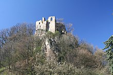
- Ruins of Lednica Castle above the village, currently not accessible


