List of cultural monuments in Am Ettersberg
In the list of cultural monuments in Am Ettersberg , all cultural monuments of the districts of the Thuringian rural community Am Ettersberg ( district of Weimarer Land ) are listed (as of April 26, 2012).
Berlstedt
- Single monument
| image | location | Official name | description |
|---|---|---|---|

|
church | ||
| Ballstedter Strasse | VVN memorial stone (death march stele) | ||
| House number 87 | Heraldic panel | ||
| Marktgasse 80 | Gate and portal | ||

|
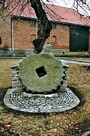
Marktgasse | Waidmühlstein |
- Soil monuments
| image | location | Official name | description |
|---|---|---|---|
| 200 m northeast of Berlstedt, on the outskirts on the road to Neumark | Burial mound, barrow | ||
| on the north-western border of the village, "Das Wahl" hill with a moat, former moated castle, castle hill (Motte) | Wasserburg " The Choice " |
Buttelstedt
- Monument ensemble
- Single monument
- Soil monuments
| image | location | Official name | description |
|---|---|---|---|
| Height just above the slope sloping to the east to the Niederndorf district at the western end of the "Sperlingsberg" path | Court place | ||

|
About 200 m north of the village between the B 85 and the sports field | Menhir, "the long stone", "whetstone" | Menhir from Buttelstedt |
Daasdorf
- Single monument
| image | location | Official name | description |
|---|---|---|---|

|
Church with a churchyard | ||
| Angergasse / Weimar Street | Signpost |
- Ground monument
| image | location | Official name | description |
|---|---|---|---|
| At the old castle. Rattle valley just east of the town of Buttelstedt and northeast of the old town | Castle hill, castle |
Grossobringen
- Monument ensembles
| image | location | Official name | description |
|---|---|---|---|
Town center with:
|
- Single monument
| image | location | Official name | description |
|---|---|---|---|

|
Church with a churchyard | ||
| graveyard | Paul Schander's grave | ||
| On plan 91 | Homestead | ||
| On plan 97 | Courtyard wall with gate and portal | ||
| In Oberdorfe 78 | Gate and portal | ||
| In Oberdorfe 86 | Gate and portal | ||
| In Oberdorfe 88 | Two inscription tablets from 1591 | ||
| Village 110 | Homestead (parish) |
Haindorf
- Individual monuments
| image | location | Official name | description |
|---|---|---|---|

|
location |
Church with a churchyard | |
| House number 26 | former school | ||
| in front of house No. 26 (former school) | Waidmühlstein |
- Ground monument
| image | location | Official name | description |
|---|---|---|---|
| Height protruding to the northwest as the remainder of a larger spur, 0.3 km northwest of Haindorf, just south of the meeting point of the road from Haindorf and Krautheim to Großbrembach | Talburg, Höhenburg |
Heichelheim
- Single features;
| image | location | Official name | description |
|---|---|---|---|

|
Church with a churchyard | ||

|
At the Rabenbach | Tower windmill | |
| At the former estate | Inscription tablet from 1585 | ||
| Long Lane 45 | two inscription tablets from 1612 | ||
| No. 27 | Outbuilding of the former estate with vaulted cellar | ||
| # 56 | former school | ||
| at No. 58 | signpost |
Hottelstedt
- Single monument
| image | location | Official name | description |
|---|---|---|---|

|
Church with a churchyard | ||
| In the village 16 | Rectory | ||
| In the village | Memorial - death march stele |
Kleinobringen
- Individual monuments
| image | location | Official name | description |
|---|---|---|---|

|
Church with a churchyard | ||
| Center, on the road to Weimar | signpost |
Krautheim
- Individual monuments
| image | location | Official name | description |
|---|---|---|---|

|
Church with a churchyard | ||
| House No. 2 | Rectory | ||
| Kirchstrasse 43, 44, 45 | former manor |
Nermsdorf
- Single monument
| image | location | Official name | description |
|---|---|---|---|

|
Church with a churchyard | ||
| In the village of 1 | Homestead (former Gasthof zur Traube) | ||
| Above the little anger | Tower windmill |
Ottmannshausen
- Monument ensemble
| image | location | Official name | description |
|---|---|---|---|
Town center with:
|
- Single monument
| image | location | Official name | description |
|---|---|---|---|

|
Church with a churchyard |
Ramsla
- Individual monuments
| image | location | Official name | description |
|---|---|---|---|

|
Church with a churchyard | ||
| On plan 60 | Gate and farm building | ||
| On plan 64 | Oven plates (relief plates) | ||
| On the plan | Source enclosure and source pond | ||
| On the plan | Waidmühlstein | ||
| Kirchgasse 50 | Homestead (rectory) |
Sachsenhausen
- Monument ensemble
| image | location | Official name | description |
|---|---|---|---|
| Homestead Buttelstedter Weg 8–12 and bridge Kirchgasse / Buttelstedter Weg |
- Individual monuments
| image | location | Official name | description |
|---|---|---|---|

|
Church with a churchyard | ||
| Back alley 63 | Homestead | ||
| Hirtengasse 79 | Homestead |
Schwerstedt
- Monument ensemble
| image | location | Official name | description |
|---|---|---|---|

|
Building and park of the former estate No. 89, 90, 90 b, |
- Individual monuments
| image | location | Official name | description |
|---|---|---|---|

|
Church with a churchyard | ||
| No. 38 | former school | ||

|
No. 90 | former manor house |
Stedten am Ettersberg
- Single monument
| image | location | Official name | description |
|---|---|---|---|

|
church | ||
| Dorfstrasse 1 | Residential building (former guest house) | ||
| Dorfstrasse (near the church) | Land reform monument |
Thalborn
- Individual monuments
| image | location | Official name | description |
|---|---|---|---|

|
South of the local situation, on the northern slope of the White Mountain location |
Church with a churchyard | Quarry stone building, built in 1686 |
Vippachedelhausen
- Individual monuments
| image | location | Official name | description |
|---|---|---|---|

|
Church with a churchyard | ||
| Churchyard | Grave of an unknown Yugoslav prisoner of war | ||
| Mühlgasse 76 | manor |
- Ground monument
| image | location | Official name | description |
|---|---|---|---|

|
Burial mound on the Palm or Ballenberg north-northeast above the village, former field name "Hühnenhügel" | Burial mound |
Pastures
- Monument ensemble
| image | location | Official name | description |
|---|---|---|---|
| Location |
- Single monument
| image | location | Official name | description |
|---|---|---|---|

|
Church with a churchyard |
- Ground monument
| image | location | Official name | description |
|---|---|---|---|
| A ridge protruding to the west east of the village, a flat wall in the area of the cemetery encloses the church | Rampart | ||
| Immured in the east wall of the church at eye level | Stone cross |
Wohlsborn
- Individual monuments
| image | location | Official name | description |
|---|---|---|---|

|
Church with a churchyard | ||
| Breitenstrasse 4 (formerly 6) | Parish homestead | ||
| Herrengasse 35 | Pigeon tower | ||
| Herrengasse 39 (formerly 5) | portal |
- Soil monuments
| image | location | Official name | description |
|---|---|---|---|
| Burial mound on the Ettersberg, 2 km east-southeast of Weimar | "Bear Hill" grave mound | ||
| On the western outskirts, southeast on the garden wall of property no.54 | Stone cross (crossing) |
source
Commons : Kulturdenkmale in Am Ettersberg - Collection of pictures, videos and audio files
- Thuringian State Office for Monument Preservation: List of monuments in the district of Weimarer Land (PDF file; 420 kB)

