List of streets and squares in Sommerach
The list of streets and squares in Sommerach describes the street system of the Lower Franconian community of Sommerach in the Kitzingen district . All named streets and squares are listed as well as the national streets, as well as cycle and long-distance hiking trails .
overview
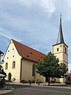
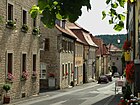
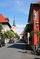
The road network in the Sommeracher Altort testifies to the historical connections of the place. Coming from Nordheim , the medieval main street, called Marktgasse for a long time , runs in a south-easterly direction through the Schwarzacher Tor towards Münsterschwarzach , where the village lord of Sommerach, the Münsterschwarzach monastery, had his seat. Other important roads run in the direction of the Main or to Volkach , which has been the nearest town since the 13th century and thus the trading center for the area.
The streets of Sommerach remained unnamed for a long time and the streets were not paved . Only the ballast was made. Since the end of the 19th century, the Sommerachers began to build properties outside of the core town, especially along Volkacher Strasse from 1875 onwards. The counting of the houses was extended to these repatriate farms; the old town had 178 house numbers for centuries .
On September 11, 1933, the local council decided to tar the main road for the first time . Between 1958 (Maintorstraße) and 1962 the tarring of all Sommerach streets was completed. At the same time, the place expanded in the direction of Gerlachshausen -Münsterschwarzach and around the cemetery. Every decade of the 20th century brought new building areas. In 1974, the town's network of roads had become so extensive that street names were introduced. Under National Socialism , some streets had already been named in line with Nazi ideology; they were renamed in 1945.
The local roads connecting Dimbach , Nordheim am Main and Volkach were gradually upgraded to district roads. After the tarry in 1966, the Sommerach – Nordheim road received this upgrade. The Sommerach – Dimbach road was completed by 1971. The strong growth in traffic, especially between Volkach and Kitzingen , led to the construction of a bypass road for State Road 2271 in 1997. The road was led around the so-called Weininsel with Sommerach. When the canal was built in the 1950s, three bridges to Sommerach had already been built.
List of named streets and squares
The list is based on the Sommeracher Ortschronik by Winfried Kraus from 2007. Further information, in particular on the monuments, can be found in Chevalley's list. The list shows the current names of the respective streets alphabetically. The origin of the name is briefly discussed, whereby it is noticeable that many streets are named after the Sommeracher's main income, viticulture . Notes refer to historical names and special features of the streets.
| Name (location) | Origin of name | Remarks | image |
|---|---|---|---|
|
At the little bridge
( Location ) |
Little bridge, a small bridge over the stream that is now underground | ||
| On the Leitersberg
( Location ) |
Leitersberg, mountain east of Sommerach (211 m above sea level) | ||
| At the Neuerb
( Location ) |
New heir, field name | ||
| At the paradeis
( Location ) |
Paradeis, probably a field name | ||
| At Rothenbühl
( Location ) |
Rothenbühl, probably a field name | ||
| At the Schwarzacher Tor
( Location ) |
Schwarzacher Tor , gate in the southeast of Sommerach | Architectural monument: Sommeracher fortification | |
| At sea
( Location ) |
Lake, standing water, quarry pond in the southwest of Sommerach | ||
| At the village wall
( Location ) |
Village wall, fortifications, southwest section of the village wall | Part of the town center Sommerach ensemble, monument: Sommeracher fortification | |
| On the climb
( Location ) |
On the climb, field name, ascent to Engelsberg | ||
|
Bacchus Street
( Location ) |
Bacchus , Roman god of wine, grape variety | ||
| Bayernstrasse
( Location ) |
Bavaria , German state | ||
|
Village ditch
( Location ) |
Village moat, part of the fortifications | Part of the town center Sommerach ensemble, monument: Sommeracher fortification |

|
|
Fasanenweg
( Location ) |
Pheasant , species of bird in the order of the chicken | ||
| Frankenstrasse
( Location ) |
Franconia , region in Germany | ||
|
gardenstreet
( Location ) |
Garden, path near the so-called moat gardens in the former village moat | ||
|
Häckergasse
( Location ) |
Häcker, Franconian name for winegrowers | 1933 to 1945 Ritter-von-Epp-Straße , part of the town center Sommerach ensemble | |
| Main road
( Location ) |
Main street, street with important functions in the town center | Formerly Marktgasse, from 1933 to 1945 from Hindenburgstraße , part of the ensemble Ortskern Sommerach, architectural monuments: u. a. Gasthof zum Schwan , Zehnthof , Vierröhrenbrunnen |

|
|
Jägergasse
( Location ) |
Hunter, person who kills game | formerly Linsengasse, part of the village center Sommerach ensemble | |
|
church Square
( Location ) |
Church, Christian sacred building | Part of the town center Sommerach ensemble, architectural monuments: including town hall, St. Eucharius |

|
|
Avenue of lime trees
( Location ) |
Lindenallee, row of trees along the road towards the Main | Old connection route to the disbanded Main ferry Sommerach |

|
|
Maintorstrasse
( Location ) |
Maintor , gate in the Sommeracher fortification | Formerly Konditorsgasse or Schlossergasse, 1933 to 1945 Adolf-Hitler-Strasse , part of the ensemble of the town center of Sommerach, architectural monuments: u. a. Maintor |

|
|
Nordheimer Strasse
( Location ) |
Nordheim am Main , municipality in the district of Kitzingen | 1933 to 1945 Von-Hindenburg-Straße, sub-ensemble of the town center of Sommerach (eastern section), monuments: u. a. Villa Sommerach , seat of the winemaker Sommerach | |
|
Raiffeisenstrasse
( Location ) |
Friedrich Wilhelm Raiffeisen (1818–1888), founder of the German cooperative | ||
|
Professor Pimple Street
( Location ) |
Johann Georg Pickel (1751–1838), professor of medicine, chemistry and pharmacy | Garden path until 1987 | |
|
Sankt-Urban-Weg
( Location ) |
Urban I. († 230), pope and saint, patron of wine and winemakers | Until 1987 Friedhofsweg | |
| St. Valentine's Street
( Location ) |
Valentin von Terni († 269), martyr and saint, patron saint of Sommerach | ||
| Schwarzacher Strasse
( Location ) |
Schwarzach am Main , municipality in the district of Kitzingen, more precisely Münsterschwarzach | Architectural monuments: Schwarzacher Tor , Sommeracher fortifications |

|
| Sonnenstrasse
( Location ) |
Sun, star in the center of the solar system, based on the name Sommerach | ||
|
Grape route
( Location ) |
Bunch of grapes , fruit of the grapevine | ||
| Turmstrasse
( Location ) |
Tower, vertically oriented structure, tower in Ortsbefestigung | Formerly Judengasse, 1933 to 1945 Schlageterstraße , part of the ensemble of the town center of Sommerach, monuments: u. a. Sommeracher site fortification, cf. Jewish community of Sommerach | |
|
Lower Maintorgasse
( Location ) |
Maintor , gate in the Sommeracher fortification | Formerly Teufelstorgasse (lower part), part of the town center Sommerach ensemble, architectural monuments: including the Milchling House | |
|
Volkacher Strasse
( Location ) |
Volkach , municipality in the district of Kitzingen | Monument: Ölbergbildstock , remnant Volkacher Tor | |
|
Wine route
( Location ) |
Wine, alcoholic drink made from the fermented berries of the grapevine | ||
| Winzerstrasse
( Location ) |
Winemaker , profession, connected with viticulture | Formerly Köhlersgasse or Kirchengasse, 1933 to 1945 Horst-Wessel-Straße, part of the ensemble of the town center of Sommerach, architectural monuments: u. a. grange |

|
|
To the Engelsberg
( Location ) |
Sommeracher Engelsberg , vineyard in Sommerach | Architectural monument: cemetery chapel , gray torture | |
| To the cat's head
( Location ) |
Sommeracher Katzenkopf , vineyard in Sommerach | ||
| To the Rosenberg
( Location ) |
Sommeracher Rosenberg , vineyard in Sommerach |
Supraregional roads, corridors, bike and hiking trails
There are several unnamed field and vineyard paths around Sommerach. They have their own names within the population that refer to historical field or vineyard names. The so-called Mittelweg in the Sommeracher Katzenkopf location is particularly well-known , where torture on the mountain can be found. The so-called Mainschleifenallee , which emerged from the old local connecting road Sommerach-Volkach and is now used as a cycle or hiking trail , also has a special name . Other national roads, bike and hiking trails in the area of Sommerach are:
- State road 2271 - State road between Martinsheim and Schweinfurt, in the Sommerach area it runs on the eastern side of the Main Canal between the Ried forest department and the canal (confluence with KT 57).
- District road KT 29 - district road between Gerlachshausen and Nordheim, in the Sommerach area it runs as Schwarzacher Straße, Hauptstraße (through the Altort), Nordheimer Straße and further between the Katzenkopf vineyard and the Main.
- District road KT 57 - District road between Volkach-Dimbach and Sommerach, in the Sommerach area it runs over the bridge on the Ried past the Viersäulenmarter , is then called Volkacher Straße and ends in the old town.
- Fränkischer Marienweg - The Franconian Marienweg was established by the Würzburg pastor Josef Treutlein as a long-distance hiking trail to special places of Marian worship in Lower Franconia since 2002. Sommerach is on route 3 in the direction of Steigerwald on the route between Maria im Weingarten , Volkach and St. Maria de Rosario , Dimbach
literature
- Denis André Chevalley: Monuments in Bavaria. Volume VI Lower Franconia. Ensembles, architectural monuments, archaeological site monuments . Munich 1985.
- Winfried Kraus: Sommerach. New chronicle of the romantic wine village on the Mainschleife . Sommerach 2007.