
Luri (Corsica)
| Luri | ||
|---|---|---|
|
||
| region | Corsica | |
| Department | Upper Corsica | |
| Arrondissement | Bastia | |
| Canton | Cap Corse | |
| Community association | Cap Corse | |
| Coordinates | 42 ° 54 ' N , 9 ° 24' E | |
| height | 0-1,136 m | |
| surface | 27.53 km 2 | |
| Residents | 835 (January 1, 2017) | |
| Population density | 30 inhabitants / km 2 | |
| Post Code | 20228 | |
| INSEE code | 2B152 | |
 Luri |
||

Luri is a municipality on Cap Corse on the French island of Corsica. It belongs to the Corsica region , the Haute-Corse department , the Corte arrondissement and the canton of Cap Corse .
geography
Luri borders the Tyrrhenian Sea to the east . Neighboring communities are Meria in the north, Pino in the west, Barrettali in the southwest and Cagnano in the south. The settlement area is on average 600 meters above sea level and consists of the Vallée de Luri with the villages of Santa Severa, Tufo, Campu, Renola, Piazza, Poggio, Castiglione and Castello, Luri Suprano with the villages of Liccetu, Fieno, Spergane, Piana and Alzetu.
Population development
| year | 1962 | 1968 | 1975 | 1982 | 1990 | 1999 | 2008 | 2014 |
|---|---|---|---|---|---|---|---|---|
| Residents | 622 | 615 | 540 | 564 | 671 | 750 | 694 | 845 |
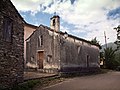
Attractions
- 11th century Château de Motti
- Château de Poggi Luri from the 13th century

Chapel of Sant'Antone
Chapel of San Roccu

San Salvado bell tower

Saint-Pierre church

Tour de Sénèque

former barracks, today a post office


