
Tomino
| Tomino | ||
|---|---|---|
|
||
| region | Corsica | |
| Department | Upper Corsica | |
| Arrondissement | Bastia | |
| Canton | Cap Corse | |
| Community association | Cap Corse | |
| Coordinates | 42 ° 57 ' N , 9 ° 27' E | |
| height | 0-414 m | |
| surface | 5.8 km 2 | |
| Residents | 208 (January 1, 2017) | |
| Population density | 36 inhabitants / km 2 | |
| Post Code | 20240 | |
| INSEE code | 2B327 | |
 Tomino |
||

Tomino is a municipality on the Cap Corse of the French island of Corsica . It belongs to the Corsica region , the Haute-Corse department , the Bastia arrondissement and the canton of Cap Corse .
geography
The settlement area is an average of 200 meters above sea level and consists of the villages Mandolacce, A Girasca, Poggio, Stopione, La Marina, Valle and A Costa. Tomino borders the Tyrrhenian Sea to the east . Neighboring communities are Rogliano in the north and Meria in the south.
Population development
| year | 1962 | 1968 | 1975 | 1982 | 1990 | 1999 | 2008 | 2017 |
|---|---|---|---|---|---|---|---|---|
| Residents | 156 | 130 | 147 | 178 | 193 | 186 | 213 | 208 |

San Nicolao Church

Chapel of San Roccu

Chapel of Sant'Antonio

Tower of Poggio
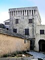
Tour carrée


Web links
Commons : Tomino - collection of images, videos and audio files