
Brando (Corsica)
| Brando | ||
|---|---|---|
|
||
| region | Corsica | |
| Department | Upper Corsica | |
| Arrondissement | Bastia . | |
| Canton | Cap Corse | |
| Community association | Cap Corse | |
| Coordinates | 42 ° 47 ' N , 9 ° 29' E | |
| height | 0-1,306 m | |
| surface | 22.22 km 2 | |
| Residents | 1,630 (January 1, 2017) | |
| Population density | 73 inhabitants / km 2 | |
| Post Code | 20222 | |
| INSEE code | 2B043 | |
 Brando |
||

Brando is a municipality on the French Mediterranean island of Corsica . It is the main town (chief lieu) of the canton of Cap Corse in the Arrondissement of Bastia and in the Haute-Corse department .
geography
Brando is located on the Cap Corse peninsula and borders the Mediterranean Sea to the east . The settlement area is an average of 300 meters above sea level and consists of the villages Lavasina, Erbalunga, Pozzo, Silgaggia, Poretto, Friscolaccio, Castello and Mausoleo. Local elevations are called Cima di e Follicie (1324 m) (with the cave Grotta a l'Albucciu ), Monte Stello (1306 m), and Monte Capra (1206 m). The neighboring communities are Sisco in the north, Santa-Maria-di-Lota in the south, Olmeta-di-Capocorso in the west and Olcani in the northwest.
Population development
| year | 1962 | 1968 | 1975 | 1982 | 1990 | 1999 | 2006 | 2012 |
|---|---|---|---|---|---|---|---|---|
| Residents | 967 | 1,066 | 1,157 | 1,353 | 1,334 | 1,527 | 1,542 | 1,654 |
Attractions
- Castles in Brando and Lavasina
- Former Benedictine monastery Erbalunga (1862 to 1963 established by the by de Thérèse Bavoz founded Benedictine Abbey Pradines )
- Genoese towers in Erbalunga, Sagro and Poretto
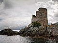
Genoese tower from Erbalunga
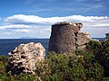
Sagro Genoese Tower
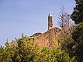
Ruins of the Castello Monastery

former Franciscan convent of Lavasina

Chapel of the Brotherhood of the Holy Cross ( Chapelle de la Confrérie de la Sainte-Croix ) in Silgaggia

Chapel of Santa Maria Assunta in Silgaggia

Benedictine monastery

Erbalunga port facility

Mairie Brando


