Santa-Maria-di-Lota
| Santa-Maria-di-Lota | ||
|---|---|---|
|
|
||
| region | Corsica | |
| Department | Upper Corsica | |
| Arrondissement | Bastia | |
| Canton | Cap Corse | |
| Community association | Bastia | |
| Coordinates | 42 ° 45 ′ N , 9 ° 26 ′ E | |
| height | 0-1,198 m | |
| surface | 13.2 km 2 | |
| Residents | 1,722 (January 1, 2017) | |
| Population density | 130 inhabitants / km 2 | |
| Post Code | 20200 | |
| INSEE code | 2B309 | |
| Website | http://www.santa-maria-di-lota.fr/ | |
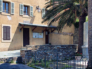
 Town hall of Santa-Maria-di-Lota in Figarella |
||
Santa-Maria-di-Lota (Corsican: Santa Maria di Lota ) is a French commune with 1,722 inhabitants (as of January 1, 2017) in the Haute-Corse department on the Mediterranean island of Corsica . It belongs to the canton of Cap Corse and the Arrondissement of Bastia . The inhabitants are called Lutinchi .
geography
Santa-Maria-di-Lota is located on the Tyrrhenian Sea . The small river Poggiolo flows into the sea here. Santa-Maria-di-Lota is surrounded by the neighboring communities of Brando in the north, Olmeta-di-Capocorso in the west, Farinole in the southwest and San-Martino-di-Lota in the south.
Santa-Maria-di-Lota consists of three localities (former municipalities): Ficarella (also: Figarella ), Mandriale and Partine and the hamlets of San Giacintu , Sorbinca , Voltojo and Miomo .
The former route nationale 198 (today's D80) runs through the municipality .
Population development
| 1962 | 1968 | 1975 | 1982 | 1990 | 1999 | 2006 | 2012 |
|---|---|---|---|---|---|---|---|
| 538 | 987 | 1,583 | 1,566 | 1,826 | 1,791 | 1.938 | 2.005 |
Attractions
- Santa Maria Assunta Church
- San Teofalu de Miomo church
- Notre-Dame-du-Mont-Carmel chapel
- Chapel of San Giovanni
- Chapel of L'Annonciation de Partine
- Dominican convent of San Ghjacintu
- Miomo tower


