
Ersa (Corsica)
| Ersa | ||
|---|---|---|
|
||
| region | Corsica | |
| Department | Upper Corsica | |
| Arrondissement | Bastia | |
| Canton | Cap Corse | |
| Community association | Cap Corse | |
| Coordinates | 42 ° 59 ′ N , 9 ° 23 ′ E | |
| height | 0-562 m | |
| surface | 20.45 km 2 | |
| Residents | 154 (January 1, 2017) | |
| Population density | 8 inhabitants / km 2 | |
| Post Code | 20275 | |
| INSEE code | 2B107 | |
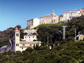
 Poggio, municipality of Ersa |
||

Ersa is a municipality on Cap Corse on the French island of Corsica . The residents call themselves Ersinchi .
geography
Ersa is the northernmost municipality of the Haute-Corse department and the island of Corsica. It borders the Ligurian Sea to the north and the Mediterranean Sea to the northwest . The small island “Île de la Giraglia” and the scattered settlements of Ersa, Barcaggio, Tollare, Poggio, Cocinco, Gualdo, Botticella and Granaggiolo belong to the municipality. The settlement area is on average 260 meters above sea level. Neighboring communities are Rogliano in the east and south and Centuri in the south and southwest.
Population development
| year | 1962 | 1968 | 1975 | 1982 | 1990 | 1999 | 2006 | 2016 |
| Residents | 246 | 236 | 148 | 113 | 125 | 132 | 151 | 152 |
| Sources: Cassini and INSEE | ||||||||

Remains of the Saint-Nicolas chapel
Botticella with the Saint-Jean-Baptiste chapel

Saint-Pierre chapel in the hamlet of Cocinco

Sainte-Anne chapel in the hamlet of Tollare
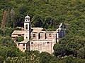
Chapel of Santa Maria Nativita
former convent of Santa Maria Assunta
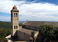
Church of Sainte-Andrea, Monument historique


