Rogliano (Corsica)
| Rogliano | ||
|---|---|---|
|
|
||
| region | Corsica | |
| Department | Upper Corsica | |
| Arrondissement | Bastia | |
| Canton | Cap Corse | |
| Community association | Cap Corse | |
| Coordinates | 42 ° 57 ' N , 9 ° 25' E | |
| height | 0-602 m | |
| surface | 26.7 km 2 | |
| Residents | 563 (January 1, 2017) | |
| Population density | 21 inhabitants / km 2 | |
| Post Code | 20247 | |
| INSEE code | 2B261 | |
 View of the village of Bettolacce in the municipality of Rogliano |
||
Rogliano ( Corsican Ruglianu ) is a French commune with 563 inhabitants (as of January 1, 2017) in the Haute-Corse department on the Mediterranean island of Corsica . It belongs to the canton of Cap Corse . It consists of eight hamlets that are located in Cap Corse at the foot of Monte Poggio, amid olive and chestnut groves. The etymology of the place name Rogliano (Pagus Aurelianus) refers to a former Roman settlement .
The place had a big visit in December 1869 when the Empress Eugenie called the port of Macinaggio with the imperial yacht after she had inaugurated the Suez Canal.
history
The ruins of three castles, a monastery and fortified (partly dilapidated) towers are a reminder of the former importance of the place where the famous da Mare family had lived since the 12th century. She lived in the castle of San Colombano and ruled over most of the Corsican North Cape. The churches of Saint-Agnel (16th century) and Saint-Côme-et-Saint-Damien have been preserved.
Attractions
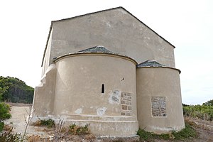
The pre-Romanesque two - apse church of Santa Maria della Chiappella is located in the village .

