
Montferrier
| Montferrier | ||
|---|---|---|
.svg)
|
|
|
| region | Occitania | |
| Department | Ariège | |
| Arrondissement | Pamiers | |
| Canton | Pays d'Olmes | |
| Community association | Communauté de communes du Pays d'Olmes | |
| Coordinates | 42 ° 54 ' N , 1 ° 48' E | |
| height | 548-2,343 m | |
| surface | 51.79 km 2 | |
| Residents | 495 (January 1, 2017) | |
| Population density | 10 inhabitants / km 2 | |
| Post Code | 09300 | |
| INSEE code | 09206 | |
 Montferrier |
||

Montferrier is a French commune with 495 inhabitants (as of January 1, 2017) in the Ariège department in the Occitanie region . It belongs to the canton of Pays d'Olmes and the Arrondissement of Pamiers .
Neighboring communities are Nalzen in the north-west, Roquefixade in the north, Villeneuve-d'Olmes and Bénaix in the north-east, Montségur in the east, Axiat and Appy in the south-east, Caychax and Senconac in the south, Cazenave-Serres-et-Allens in the south-west and Freychenet in the west.
Population development
| year | 1962 | 1968 | 1975 | 1982 | 1990 | 1999 | 2008 | 2015 |
|---|---|---|---|---|---|---|---|---|
| Residents | 812 | 742 | 735 | 733 | 748 | 664 | 647 | 508 |
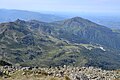
Monts d'Olmes near Montferrier
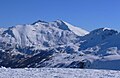
Pic de Saint-Barthélemy elevation between Montségur and Montferrier


Web links
Commons : Montferrier - Collection of images, videos and audio files