La Tour-du-Crieu
|
La Tour-du-Crieu La Tor-del-Criu |
||
|---|---|---|

|
|
|
| region | Occitania | |
| Department | Ariège | |
| Arrondissement | Pamiers | |
| Canton | Pamiers-2 | |
| Community association | Portes d'Ariège Pyrénées | |
| Coordinates | 43 ° 6 ′ N , 1 ° 39 ′ E | |
| height | 297-341 m | |
| surface | 10.28 km 2 | |
| Residents | 3,167 (January 1, 2017) | |
| Population density | 308 inhabitants / km 2 | |
| Post Code | 09100 | |
| INSEE code | 09312 | |
| Website | www.la-tour-du-crieu.fr | |
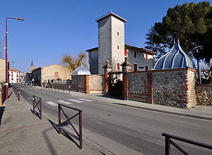
 La Tour-du-Crieu Town Hall on Avenue du Pal |
||
La Tour-du-Crieu ( Occitan La Tor-del-CRIU ) is a French municipality with 3167 inhabitants (as of January 1 2017) in the department of Ariège in the region Occitania is. The municipality is part of the Pamiers arrondissement and the Pamiers-2 canton (until 2015: Pamiers-Est canton ). The inhabitants are called Critouriens .
location
La Tour-du-Crieu is located about three kilometers east of Pamiers and is surrounded by the neighboring communities Pamiers in the north and west, Le Carlaret in the northeast, Saint-Amadou in the east, Les Pujols in the southeast and Verniolle in the south. The Crieu River runs along the western boundary of the municipality .
history
Until 1915 the place was still called Les Allemans and was renamed because of the similarity to Allemands ( Germans ) during the First World War .
Population development
| 1962 | 1968 | 1975 | 1982 | 1990 | 1999 | 2006 | 2017 |
|---|---|---|---|---|---|---|---|
| 616 | 745 | 1,162 | 1,640 | 2.011 | 1,978 | 2,221 | 3,167 |
| Sources: Cassini and INSEE | |||||||
Buildings
- Saint-Paul church, rebuilt in the 17th century
- Chapel, built from 1854 to 1864, restored in 1958
- today's town hall (called Le Château ) from the 17th century
- Bonrepeaux Castle (also called Bonrepos ) from the 18th century
Personalities
- Bernard Saisset (1232–1314), first bishop of Pamiers

