Mosebolle
|
Mosebolle
City of Meschede
Coordinates: 51 ° 18 ′ 21 ″ N , 8 ° 21 ′ 11 ″ E
|
|
|---|---|
| Height : | 460 m above sea level NHN |
| Residents : | 27 (Jan. 1, 2016) |
| Incorporation : | 1st January 1975 |
| Postal code : | 59872 |
| Area code : | 0291 |
|
Mosebolle
|
|
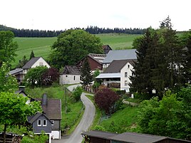
Mosebolle is a district of the city of Meschede in the North Rhine-Westphalian Hochsauerlandkreis .
geography
The place is about three kilometers east of Remblinghausen . Bordering places are Blüggelscheidt , Löllinghausen and Klause . Mosebolle is located on the landscape protection area of local open spaces between Klause and Mosebolle as well as on the landscape protection area of the valley areas of the Nierbach and side valleys near Blüggelscheidt . The Moseboller Bach rises about 300 meters south of the village, flows north and flows into the Nierbach after about two kilometers .
history
Mosebolle was first mentioned in a document in 1402 and 1441. Early clues about the size of the place result from an appraisal register (used to collect taxes) for the year 1543. According to this, there were four appraisers in “Morßböle”; the number should correspond to the existing farms at that time.
As part of the municipal reorganization , Mosebolle became a district of the new town of Meschede on January 1, 1975.
religion
Mosebolle belongs to the parish Remblinghausen in the pastoral area Meschede Bestwig. The Johannes von Nepomuk Chapel, which is a listed building, is located in the village.
Web links
Individual evidence
- ↑ Michael Flöer: The place names of the Hochsauerlandkreis. Bielefeld 2013, p. 353., ISBN 978-3-89534-946-1 .
- ↑ Estimation register 1543 for the Sauerland in the Electorate of Cologne (online), PDF p. 109, accessed on January 20, 2018

