Grevenstein
|
Grevenstein
City of Meschede
|
|
|---|---|
| Coordinates: 51 ° 18 ′ 8 ″ N , 8 ° 7 ′ 46 ″ E | |
| Height : | 395 m above sea level NHN |
| Residents : | 858 (Dec. 31, 2017) |
| Incorporation : | 1st January 1975 |
| Postal code : | 59872 |
| Area code : | 02934 |
|
View of Grevenstein
|
|
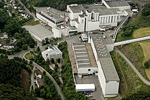
The Sauerland resort Grevenstein is a titular town in North Rhine-Westphalia. On December 31, 2017, Grevenstein had 858 inhabitants. Since the municipal reorganization in 1975 , the place belongs to the city of Meschede in the Hochsauerlandkreis . Before that he belonged to the Arnsberg district . Grevenstein is the seat of the Veltins brewery.
geography
Grevenstein lies at an altitude of up to 630 m above sea level. NHN in the Sauerland-Rothaargebirge nature park on the upper reaches of the Arpe immediately east of the Großer Sonnenstück .
history
On February 12, 1324 Grevenstein was mentioned for the first time in a document from the knight Dietrich von Helden and apparently already had municipal self-government. When the city was founded by the Counts of Arnsberg , the fortified place settled around a castle on a hilltop above the Arpe valley. Remains of the original castle tower now form the church tower of the parish church. The city belonged to the Hanseatic League and is said to have had trade relations with the Baltic countries.
During the Thirty Years War , Swedish and imperial troops invaded the city on various occasions . The Grevensteiner Schützenbruderschaft St. Michael traces its origin back to the year 1664.
Pastor Michael Stappert , also Michael Stapirius , was an opponent of the witch hunt in Grevenstein . He wrote the spectacles tract, which was only published in 1676 by the Amsterdam citizen Hermann Löher in his book Hochnötige Unterthanige Wemütige Klage Der Pious Invalid . Until 1621 he was pastor in the Sauerland town of Hirschberg (Warstein) . The Michael-Stappert-Haus and a bronze relief on the Hexenturm in Rüthen remind of his work .
The plague in the 17th century and city fires in 1746 and 1843 repeatedly caused setbacks in urban development. Since the 18th century, the place moved more into the valley (Bachstrasse). The number of inhabitants fell to 524 by 1871, rose to 598 by 1939 and only increased significantly after the Second World War.
The expansion of the road network and a public water supply, which was donated in 1893 by the Grevensteiner Peter Conrad Nagel , who emigrated to Pennsylvania , improved living conditions. A rifle hall was built in 1893. In the second half of the 19th century, the Veltins brewery developed from a small pub brewery , which today characterizes the place.
In 1891 a new cemetery was laid out on the Ostfeld. Six grave sites (see Jewish cemetery (Grevenstein) ) also testify to two Jewish families that can be traced back to Grevenstein in the first half of the 19th century. Her house on Burgstrasse was the target of the November pogrom in 1938 . The traces of Lilli Lilienfeld, the last Jewish woman from Grevenstein at the time, are lost with her deportation to the Litzmannstadt ghetto in the following years.
At the end of the war, the place housed hundreds of refugees and evacuees as well as Eastern European forced laborers . In the course of the Ruhrkesselkampf on April 11, 1945 soldiers of the 5th US Infantry Division captured Grevenstein after a short bombardment from the Ostfeld and thus ended the National Socialist rule.
After the World War, the tourist infrastructure developed with hotels, guest houses, hiking trails, a ski lift and an outdoor swimming pool. The outdoor pool has been operated by a non-profit association since 2006.
On January 1, 1975, Grevenstein was incorporated into the district town of Meschede.
coat of arms

|
Blazon :
In silver a gold-armored, red-tongued blue eagle. Description: The oldest seal impression from 1348 shows the sovereign eagle of the Counts of Arnsberg. The Arnsberg coat of arms collection from 1700 shows this seal image in the colors black in silver, according to the colors of the Electorate of Cologne. In 1911 the colors of the Counts of Arnsberg were adopted. The colors were mixed up, so that “blue in silver” was used. Official approval took place on June 24, 1911. |
Economy and Infrastructure
The largest company in town is the Veltins brewery .
Attractions
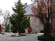
Among the attractions of the place, the church is part of St. Anthony Hermit at the highest elevation of the site and the Nothelfer chapel on the East Field and the castle outbuildings; the former residence of the Burgmann family von Schade from the 16th century.
Personalities
- Michael Stappert (* around 1585 in Meiste zu Rüthen , † 1663 in Grevenstein), also Michael Stapirius , a German pastor and opponent of the persecution of witches
- Johannes Franz Becker (born December 18, 1689 in Meinkenbracht; † January 21, 1777), Catholic priest and mining entrepreneur
- Josefa Berens-Totenohl (born March 30, 1891 in Grevenstein, † June 6, 1969 in Meschede ), successful blood-and-soil writer and painter in the 1930s . In 1991 a plaque was placed on the house where she was born.
- Lina S. Schüerhoff, painter, lived in the preserved castle building in the middle of the 20th century, where she created numerous still lifes with flowers and landscapes.
- Friedrich Becker , (born May 25, 1922 in Ende (Herdecke) near Herdecke , † May 15, 1997 in Düsseldorf ), goldsmith , lived in Grevenstein until he was 14 years old.
- Peter Conrad Nagel (born May 15, 1825 in Grevenstein, † March 12, 1911 in Wilkes-Barre , Pennsylvania) worked as a missionary Catholic priest in Pennsylvania.
- Rosemarie Veltins (born February 14, 1938 in Grevenstein; † April 30, 1994 ibid.) Was an entrepreneur
- Klaus Thüsing (born February 22, 1940 in Grevenstein); The social scientist and SPD - Bundestag spent his early childhood and school years to 1948 in Grevenstein.
- Franz Anton Lohage (born March 31, 1815 in Grevenstein, † April 22, 1872 in Unna), ironworker, chemist and inventor.
literature
- Clemens Liedhegener: Grevenstein through the ages . Bigge 1965.
- Reinhard Köhne: 350 million year old natural sculpture near Grevenstein. In: Sauerland, 37 (2004), 4, p. 185.
- Detlev Arens: Sauerland with Siegerland and Wittgensteiner Land: culture u. Landscape in the mountainous south of Westphalia. Cologne 1985, ISBN 3-7701-1534-1 .
- Wilfried Ehbrecht: Grevenstein (Historical Atlas of Westphalian Cities, Volume 2). Münster 2014, ISBN 978-3-87023-368-6
Web links
- grevenstein.de
- Description of the Grevenstein parish church on the website of the city of Meschede
- [1]
- Panorama photos Grevenstein
Individual evidence
- ↑ Meschede: The Meschede population statistics (PDF; 59 kB), accessed on February 16, 2018
- ↑ Reinhard Köhne: in yearbook Hochsauerlandkreis 2000, ed. The district administrator of the HSK, Podszun Verlag Brilon, ISBN 3-86133-230-2 , p. 88
- ↑ Michael Senger: Search for traces. In: Jewish life in the Hochsauerlandkreis (= Hochsauerlandkreis series of publications, Volume III), ed. by Rudolf Brüschke, Norbert Föckeler. Fredeburg 1994, ISBN 3-930271-18-4 , p. 326ff.
- ↑ http://www.737thtankbattalion.org/archives/archives05.htm Photos from the invasion of US troops in 1945
- ^ Federal Statistical Office (ed.): Historical municipality directory for the Federal Republic of Germany. Name, border and key number changes in municipalities, counties and administrative districts from May 27, 1970 to December 31, 1982 . W. Kohlhammer, Stuttgart / Mainz 1983, ISBN 3-17-003263-1 , p. 335 .
- ^ Eduard Belke, Alfred Bruns, Helmut Müller: Communal coats of arms of the Duchy of Westphalia. Arnsberg 1986, ISBN 3-87793-017-4 , p. 150


