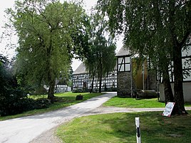
Horbach (Meschede)
|
Horbach (Meschede)
City of Meschede
Coordinates: 51 ° 17 ′ 58 ″ N , 8 ° 17 ′ 0 ″ E
|
|
|---|---|
| Height : | 187 m above sea level NHN |
| Residents : | 14 (Jan. 1, 2012) |
| Incorporation : | 1st January 1975 |
| Postal code : | 59872 |
| Area code : | 0291 |
|
Horbach
|
|
Horbach is a district of the city of Meschede in the North Rhine-Westphalian Hochsauerlandkreis in Germany .
geography
The place is about five kilometers south of Meschede. The landscape protection areas of the Horbach valley and the side valleys south of Remblinghausen and the open spaces west of Horbach border the site. The stream of the same name flows through Horbach and flows south of Vellinghausen into the Hennetalsperre . Adjacent places are Nichtinghausen and Remblinghausen .
history
In the 14th century, Horbach (then Horbeke) was one of the 40 Fronhöfe of the Meschede Monastery . The Horbacher Fronhof was first mentioned in 1344 as a fief of the Meschede Monastery. As part of the municipal reorganization , Horbach became a district of the new city of Meschede on January 1, 1975.
religion
In Horbach there is the listed Catholic St. Apollonia Chapel.
Web links
Individual evidence
- ↑ Müller's Grosses Deutsches Ortsbuch 2012. Volume 1, de Gruyter, 2012, ISBN 978-3-11-027420-2 , p. 636.
- ↑ Meschede.de: Grundherrschaft des Stift Meschede in the Middle Ages (PDF), p. 5, accessed on July 1, 2018.
- ^ Johann Suibert Seibertz : Document book on the regional and legal history of the Duchy of Westphalia, 1300-1400. Ritter, Arnsberg 1843, p. 682.
- ^ Horbacher-hof.de: History accessed on July 1, 2018.
- ↑ Meschede.de: List of monuments in the Meschede city area (PDF), accessed on July 1, 2018.

