Fronnenbroich / Buschhorner Bruch nature reserve
|
Fronnenbroich / Buschhorner Bruch nature reserve
|
||
|
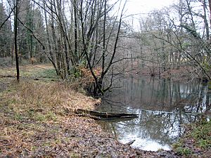
Pinge of the Eduard & Amalia mine , popularly known as "The Green Pond" |
||
| location | Bergisch Gladbach , North Rhine-Westphalia , Germany | |
| surface | 14,842 hectares | |
| Identifier | GL-033 | |
| WDPA ID | 163159 | |
| Geographical location | 51 ° 1 ' N , 7 ° 6' E | |
|
|
||
| Setup date | 1994 | |
| Framework plan | Landscape plan south district (Bergisch Gladbach, Overath, Rösrath) | |
| administration | Lower landscape authority Rheinisch-Bergischer Kreis | |
The Fronnenbroich / Buschhorner Bruch nature reserve is located south of Buschhorn in the Nussbaum district of Bergisch Gladbach . It is bordered by the Hufer Weg in the west, the Nussbaumer Weg in the north and the built-up areas of Nussbaum in the east and south.
vegetation
The nature serves to maintain and secure a moorigsauren fraction Forest with birch , myrtle plants and a Kalksumpf in endangered plant species. In addition, the near-natural alder , ash , bog birch and mixed deciduous forest stands are to be protected as habitats for rare animal and plant species ( dragonflies , birds, plants). Furthermore, the water balance in the quarries and swamp areas, the alluvial forests, the quarry and swamp forests and still waters are to be protected.
Mining
From 1848 to 1884, mining on iron ore , lead ore and pyrites was carried out here at the Eduard & Amalia mine . Then, until the 1930s, there were repeated, with interruptions, individual test work. The so-called green pond is the ping of an earlier opencast mine .
See also
Individual evidence
- ^ "Südkreis" landscape plan (Bergisch Gladbach, Overath, Rösrath), text part. (PDF) The District Administrator of the Rheinisch-Bergisches Kreis, 2008, pp. 61–62 , accessed on February 21, 2017 .
- ^ Herbert Stahl (editor), Gerhard Geurts , Hans-Dieter Hilden, Herbert Ommer : Das Erbe des Erzes. Volume 3: The pits in the Paffrath Kalkmulde. Bergischer Geschichtsverein Rhein-Berg, Bergisch Gladbach 2006, ISBN 3-932326-49-0 , p. 50ff. ( Series of publications by the Bergisches Geschichtsverein Rhein-Berg eV 49).
Web pages
- Nature reserve “Fronnenbroich / Buschhorner Bruch” (GL-033) in the specialist information system of the State Office for Nature, Environment and Consumer Protection in North Rhine-Westphalia


