New Castle County
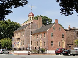
 New Castle County Courthouse |
|
| administration | |
|---|---|
| US state : | Delaware |
| Administrative headquarters : | Wilmington |
| Address of the administrative headquarters: |
New Castle County County Building 800 North French Street Wilmington, DE 19801 |
| Foundation : | 1664 |
| Made up from: | the Dutch colony of Nieuw Amstel |
| Area code : | 001 302 |
| Demographics | |
| Residents : | 538,479 (2010) |
| Population density : | 487.8 inhabitants / km 2 |
| geography | |
| Total area : | 1278 km² |
| Water surface : | 174 km² |
| map | |
| Website : www.co.new-castle.de.us | |
The New Castle County is the northernmost and most populous of the three counties of the US -amerikanischen State of Delaware . At the 2010 census , the county had 538,479 people and a population density of 487.8 people per square kilometer. The county seat is Wilmington .
The county is part of metropolitan Philadelphia-Camden-Wilmington (also Delaware Valley called), which extends over the four states of Delaware, Maryland , New Jersey and Pennsylvania extends.
geography


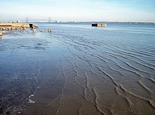
The county is located in the northeast of the Delmarva Peninsula at the mouth of the Delaware River , which forms the border with New Jersey in the northeast and east. In the north and northwest of the county by the will Twelve - Mile Circle , a radius of twelve miles around the city of New Castle beaten arc from the Delaware River to the Mason - Dixon - line , separated from Pennsylvania. The county borders Maryland to the west.
The county has an area of 1,278 square kilometers, of which 174 square kilometers are water (13.62%).
The following counties in Delaware, Pennsylvania, New Jersey and Maryland border New Castle County:
|
Chester County, Pennsylvania |
Delaware County, Pennsylvania |
Gloucester County, New Jersey |
|
Cecil County, Maryland |

|
Salem County, New Jersey |
|
Kent County, Maryland |
Kent County |
history
| Population development | |||
|---|---|---|---|
| Census | Residents | ± in% | |
| 1790 | 19,688 | - | |
| 1800 | 25,361 | 28.8% | |
| 1810 | 24,429 | -3.7% | |
| 1820 | 27,899 | 14.2% | |
| 1830 | 29,720 | 6.5% | |
| 1840 | 33,120 | 11.4% | |
| 1850 | 42,780 | 29.2% | |
| 1860 | 54,797 | 28.1% | |
| 1870 | 63,515 | 15.9% | |
| 1880 | 77,716 | 22.4% | |
| 1890 | 97.182 | 25% | |
| 1900 | 109,697 | 12.9% | |
| 1910 | 123.188 | 12.3% | |
| 1920 | 148.239 | 20.3% | |
| 1930 | 161.032 | 8.6% | |
| 1940 | 179,562 | 11.5% | |
| 1950 | 218,879 | 21.9% | |
| 1960 | 307,446 | 40.5% | |
| 1970 | 385.856 | 25.5% | |
| 1980 | 398.115 | 3.2% | |
| 1990 | 441,946 | 11% | |
| 2000 | 500,265 | 13.2% | |
| 2010 | 538.479 | 7.6% | |
| until 1890 1900–1990 2000–2010 | |||
After the area was mainly populated by the Lenni Lenape people, in 1638 Swedish traders founded Fort Christina not far from today's city center of Wilmington, the first European settlement in what is now New Castle County, from where the former colony of New Sweden expanded.
In order to prevent further expansion of the Swedish colony, the Dutch built Fort Casimir in 1651 , which later became the Nieuw Amstel and is now the New Castle. In 1655 the Dutch conquered the Swedish colony under Peter Stuyvesant .
In 1664 the entire area fell to England and became part of the New York colony. The county was founded on August 8, 1673, although it is unclear whether it was named after the English city of Newcastle upon Tyne or the military and politician William Cavendish, 1st Duke of Newcastle . In 1680 what is now Kent County (Delaware) was split off. In 1682 the area was ceded by the colony of New York to the possessions of William Penn and in 1683 annexed to Pennsylvania . In 1704 the three lower counties that make up today's state of Delaware got their own parliament and in 1710 their own administration, whose seat was in the city of New Castle.
Two months after the United States declared independence, the state of Delaware was completely separated from Pennsylvania. During the American Revolutionary War , the capital of Delaware was relocated to Dover in the south .
After the Civil War , the administrative seat of New Castle County was moved to Wilmington.
Demographic data
According to the 2010 census , New Castle County had 538,479 people in 198,499 households. The population density was 487.8 people per square kilometer. Statistically, 2.6 people lived in each of the 198,499 households.
The racial the population was composed of 65.5 percent white, 23.7 percent African American, 0.3 percent Native American, 4.3 percent Asian and other ethnic groups; 2.5 percent were descended from two or more races. Regardless of ethnicity, 8.7 percent of the population was Hispanic or Latino of any race.
23.2 percent of the population were under 18 years old, 64.5 percent were between 18 and 64 and 12.3 percent were 65 years or older. 51.6 percent of the population was female.
The median income for a household was 62,474 USD . The per capita income was $ 31,220. 10.3 percent of the population lived below the poverty line.
traffic

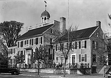
222 buildings and sites in the county are listed on the National Register of Historic Places (NRHP) (as of March 11, 2020) and eleven places have the status of National Historic Landmarks , including the Holy Trinity Church , the New Castle Historic District and the New Castle Court House Museum .
There is an important seaport in Wilmington. South of Wilmington runs the Chesapeake and Delaware Canal (C&D Canal), which forms a navigable link between the Delaware River and Chesapeake Bay in neighboring Maryland to the west.
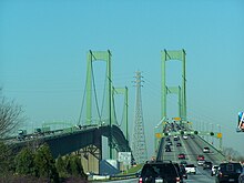
The Delaware Memorial Bridge is the only road bridge over the Delaware River from Delaware and New Jersey. It leads Interstate 295 and US Highway 40 together from New Castle County to Pennville Township in New Jersey.
New Castle Airport is located in the northern center of New Castle County, 13.9 km southwest of Wilmington .
Places in New Castle County
|
|
Census-designated places (CDP)
1 - partially in Kent County
structure
New Castle County is divided into 11 Census County Divisions (CCD):
| CCD | Population (2010) | FIPS |
|---|---|---|
| Brandywine CCD | 77,182 | 10-90148 |
| Glasgow CCD | 39,748 | 10-91110 |
| Lower Christiana CCD | 36,558 | 10-91924 |
| Middletown-Odessa CCD | 52,453 | 10-92072 |
| Newark CCD | 68,723 | 10-92738 |
| New Castle CCD | 86,227 | 10-92812 |
| Piedmont CCD | 29,569 | 10-92960 |
| Pike Creek-Central Kirkwood CCD | 42,016 | 10-93108 |
| Red Lion CCD | 8,816 | 10-93256 |
| Upper Christiana CCD | 26,336 | 10-93848 |
| Wilmington CCD | 70,851 | 10-93996 |
Web links
Individual evidence
- ↑ GNIS-ID: 217270. Retrieved on February 22, 2011 (English).
- ↑ a b c U.S. Census Bureau, State & County QuickFacts - New Castle County, DE. Retrieved May 31, 2012
- ^ National Association of Counties.Retrieved May 31, 2012
- ↑ Extract from the National Register of Historic Places - No. 72000285. Retrieved August 8, 2011
- ^ US Census Bureau _ Census of Population and Housing.Retrieved February 17, 2011
- ^ Extract from Census.gov.Retrieved February 15, 2011
- ↑ Charles Curry Aiken, Joseph Nathan Kane: The American Counties: Origins of County Names, Dates of Creation, Area, and Population Data, 1950-2010 . 6th edition. Scarecrow Press, Lanham 2013, ISBN 978-0-8108-8762-6 , p. 221.
- ↑ n2genealogy.com - New Castle County, Delaware Accessed 8 August 2011
-
↑ Search mask database in the National Register Information System. National Park Service , accessed March 11, 2020
Weekly List on the National Register Information System. National Park Service , accessed March 11, 2020.
Listing of National Historic Landmarks by State: Delaware. National Park Service , accessed March 11, 2020. - ↑ Missouri Census Data Center - Delaware ( page no longer available , search in web archives ) Info: The link was automatically marked as defective. Please check the link according to the instructions and then remove this notice. Retrieved May 30, 2012
Coordinates: 39 ° 35 ′ N , 75 ° 38 ′ W


