
Novosjolowo (Kaliningrad)
| settlement
Novosjolowo / Groß Rödersdorf
Новосёлово
|
||||||||||||||||||||||||||||
|
||||||||||||||||||||||||||||
|
||||||||||||||||||||||||||||
.svg)

Nowosjolowo ( Russian Новосёлово , German United Rödersdorf until the 19th century Rödersdorf ) is a village in the southeast of the Russian Kaliningrad Oblast (region Königsberg (Prussia) ) and is one of Pogranitschnoje selskoje posselenije (Town Pogranichny (Hermsdorf) ) in Bagrationovsky District (District Prussian Eylau ).
Geographical location
Novosjolowo is 10 kilometers west of the city of Mamonowo ( Heiligenbeil ) and 14 kilometers southeast of Laduschkin ( Ludwigsort ) on the former Reichsautobahn Berlin-Königsberg , today's Russian trunk road R 516 . The nearest train station is Mamonowo on the Polish-Russian railway line Malbork ( Marienburg (West Prussia) ) - Braniewo ( Braunsberg ) - Kaliningrad ( Königsberg (Prussia) ), a section of the former Prussian Eastern Railway . The Polish-Russian river Jarft (Russian: Wituschka, Polish: Ławta) meanders through the village and flows into the Bahnau (Russian: Mamonowka, Polish: Banówka) at Mamonowo .
history
Rödersdorf was first mentioned in a document in 1412, but the year it was founded was in the first half of the 14th century. Already at the time of the Teutonic Order , the Jarft was dammed into a mill pond, from which a mill ditch led to the Order Mill.
On April 22nd, 1469, Grand Master Heinrich Reuss von Plauen prescribed the place Rödersdorf including water mill, rectory and Schulzenhufen to Friedrich von Berenfelde as compensation for war services in the Thirteen Years' War ("City War") 1454–1466. His daughter Anna married Georg von Parck , whose family owned the estate until 1658. Then it came to the Chancellor Georg Friedrich von Creytzen auf Weßlienen (today Russian: Kunzewo).
In 1768, Weßlienen and Rödersdorf fell to Friedrich Gottfried von der Groeben , who owned it until 1831. During this time Rödersdorf was divided into Groß - and Klein Rödersdorf , with Klein Rödersdorf being the Vorwerk of Groß Rödersdorf.
The next owner was Rudolf von Auerswald , district administrator of the Heiligenbeil district and later Lord Mayor of Königsberg (Prussia) , who however sold the property again in 1845. Changing owners followed. So in 1889 a Mrs. Wendt and in 1895 a Gustav Sprengel, born in Rädtkeim, are named.
From 1911 to 1945 Reinhard Brunk managed the estate as its last owner. During this time the representative manor house was built, which - with the replacement of the original hipped roof with a flat gable roof - has been preserved to this day. The estate last comprised 525 hectares, of which 25 hectares had to be ceded for the construction of the Reichsautobahn .
In 1910 Groß Rödersdorf had 161 inhabitants, in 1933 and 1939 there were 171.
Until 1945, Groß Rödersdorf belonged to the district of Quilitten (today in Russian: Schukowka), which also included the communities of Jürkendorf (Bogdanowka), Königsdorf (no longer exist today) and Quilitten.
In Groß Rödersdorf itself there was a registry office to which Klein Rödersdorf and Jarft (both places no longer exist) belonged.
Until 1945 Groß Rödersdorf was in the district of Heiligenbeil in the administrative district of Königsberg in the Prussian province of East Prussia .
In 1947 the place was given the Russian name Novosjolowo. It was initially part of Ladushkin Raion , and is now part of Bagrationovsk Raion in Kaliningrad Oblast . The estate is still managed today.
From Novosjolowo it is to the southern Russian-Polish border, which in 2010 at the crossing point Grzechotki ( Rehfeld ) / Mamonowo ( Heiligenbeil ) II in the connection of the Russian regional road R 516 (former German Reichsautobahn Berlin – Königsberg ) to the Polish expressway S 7 was opened, six kilometers.
church
Before 1520 Rödersdorf had its own church, which was then destroyed and not rebuilt. A dilapidated building next to the manor house used as a wash house, which was demolished in 1922, was considered by the Rödersdorfers to be the remainder of the old church because of its Gothic windows.
Until 1945, Groß Rödersdorf belonged to the parish Bladiau (today Russian: Pjatidoroschnoje) in the parish of Heiligenbeil in the church province of East Prussia of the Evangelical Church of the Old Prussian Union . The last German clergyman was Pastor Heinrich Geiger .
school
The school building in Groß Rödersdorf at the foot of the Schlossberg was built in 1911.
literature
- Wulf D. Wagner: The goods of the district of Heiligenbeil in East Prussia. Rautenberg, Leer 2005, ISBN 3-7921-0640-X .
- Friedwald Moeller: Old Prussian Evangelical Pastors' Book from the Reformation to the Expulsion in 1945. Hamburg 1968.
Web links
- Groß Rödersdorf at ostpreussen.net
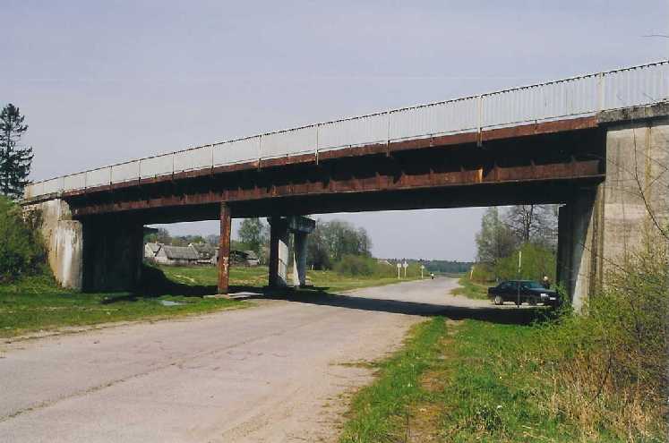
- Image of the bridge over the former motorway near Novosjolowo
- Image of the bridge over the Wituschka ( Yarft ) near Novosjolowo
- Novosjolovo bankgorodov.ru
Individual evidence
- ↑ Itogi Vserossijskoj perepisi naselenija 2010 goda. Kaliningradskaya oblastʹ. (Results of the 2010 all-Russian census. Kaliningrad Oblast.) Volume 1 , Table 4 (Download from the website of the Kaliningrad Oblast Territorial Organ of the Federal Service for State Statistics of the Russian Federation)
- ↑ Through the Указ Президиума Верховного Совета РСФСР от 17 ноября 1947 г. "О переименовании населённых пунктов Калининградской области" (Decree of the Presidium of the Supreme Soviet of the RSFSR of November 17, 1947: On the renaming of settlements in the Kaliningrad Oblast )