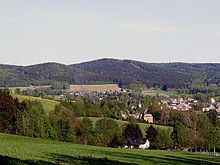
Upper Vogtland
The Upper Vogtland is the southern border region of today's Vogtlandkreis around the cities of Adorf , Schöneck , Markneukirchen and Klingenthal . It completely includes the area of the former district of Klingenthal ( Musikwinkel , forest area) and part of the former district of Oelsnitz (Bäderwinkel).
The Upper Vogtland divided both geographically and linguistically-geologically into the well to the natural environment Upper Vogtland related Südvogtland and westerzgebirgische Southeast Vogtland . Both areas are relatively sharply demarcated by the ridge line of the Hohe Brand , while in the north they gradually merge into the core and eastern Vogtland.
Landscape and geology
Scenic prevails in the upper Vogt country throughout a typical low mountains before, wherein the south central part of the Elstergebirge forms which east and north-east from Westerzgebirge is detached. Much of the landscape is covered by coniferous forest (mostly spruce ). The rivers Weisse Elster (on the Czech side of the Elster Mountains) and Göltzsch , Zwickauer Mulde and Zwota (each in the western Western Ore Mountains) have their source in the upper Vogtland . The upper Vogtland is rural, with the small towns of Adorf , Bad Elster , Klingenthal and Markneukirchen in the valleys of the White Elster, the Zwota and the Schwarzbach . The small town of Schöneck is located on a plateau in the immediate transition from the Elster to the Ore Mountains. The basement is formed by Cambrian and Ordovician slate layers in the Upper Vogtland , which were steeply vaulted during the Variscan mountain formation by rising granite magmas and have a pronounced folding structure. Two such granite plutones , the Western Ore Mountains Eibenstocker granite massif in the east and the Fichtelgebirge granite in the south, delimit the old crystalline slate area, while it continues in the north and west, partly through younger layers. In the Tertiary the Erzgebirge and the Elstergebirge were raised like clods, which resulted in a clear demolition against the Egergraben . This was associated with pronounced basalt volcanism up to the Quaternary . The mineral springs of the Upper Vogtland and the neighboring Egerland are to be regarded as residual phenomena of this volcanic activity. This weak zone is crossed by a significant deep fault in the Elstergebirge-Ore Mountains border area, which repeatedly results in earthquakes ( swarmquakes ) in the upper Vogtland .
history
The historical development of the upper Vogtland is almost identical to that of the rest of the Vogtland . In general, however, the historical settlement only began with the German settlement in the east . Sorbian place names therefore do not appear at all in the Upper Vogtland or only for field objects (e.g. rivers) that were already known from the core Vogtland and Bohemia . The late settlement, just like in the neighboring Ore Mountains , is due to the mountain location and the resulting primeval forest. During the time of the first conquest of land up to around 1500, the history of the southern Vogtland differs from that of the southeastern Vogtland and the rest of the Vogtland. The area around Markneukirchen , which belongs to the Hohenstaufen Egerland and ecclesiastically to the diocese of Regensburg , was settled by predominantly Upper Palatinate settlers from the Waldsassen monastery . This southern tip was subject to frequent changes of ownership between the bailiffs, the Margraves of Meissen and the Kingdom of Bohemia until the 16th century .
economy
The construction of musical instruments plays an important economic role, especially in the towns of Markneukirchen and Klingenthal and their immediate surroundings ( Musikwinkel ) and the spa industry in Bad Elster and Bad Brambach (Bäderwinkel). Furthermore, tourism plays an important role in the entire upper Vogtland.
traffic
The main road 92 runs through the upper Vogtland as the most important traffic axis into the neighboring Czech Republic. In Adorf, branching off the B 92, the federal road 283 begins and runs via Markneukirchen, Klingenthal to Morgenröthe-Rautenkranz across the entire upper Vogtland, it continues northwest to Aue .
Almost parallel to the B 92, the Plauen – Cheb railway crosses the upper Vogtland. The route is mainly served by the Vogtlandbahn . Other railway lines are the railway line (Chemnitz) Muldenberg-Adorf , the railway Zwotental-Klingenthal and the railway Sokolov-Klingenthal . These lines are used exclusively by the Vogtlandbahn, on the Czech side in conjunction with GW Train Regio .
Important places
OVL
After the reunification of the two German states in 1990, OVL ( Obervogtland ) was set as the license plate for the districts of Oelsnitz and Klingenthal , with one- and two-digit numbers for the district of Klingenthal and three-digit numbers for the district of Oelsnitz. For this reason, many (especially non-residents) still regard the area of these two former districts as the Obervogtland district, although there never was such a district and only a small part of the former Oelsnitz district really belongs to the Upper Vogtland.
Since November 9, 2012, the distinctive sign OVL has been reassigned - this time on request in the entire Vogtland district.
literature
- The Upper Vogtland (= values of our homeland . Volume 26). 1st edition. Akademie Verlag, Berlin 1976.

