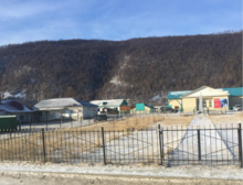
Orlik (Russia)
| Village
Orlik
Орлик
|
||||||||||||||||||||||||||||
|
||||||||||||||||||||||||||||
|
||||||||||||||||||||||||||||
Orlik ( Russian О́рлик ) is a village (selo) in the Republic of Buryatia ( Russia ) with 2555 inhabitants (as of October 14, 2010).
geography
The place is a good 530 km as the crow flies west of the republic capital Ulan-Ude in the middle of the East Sayan , a high mountain range that reaches a height of 2831 m in the vicinity of the place with the peak of the Rintschin-Chumba just under 20 km to the east . Orlik is located on the right bank of the upper reaches of the Angara tributary Oka .
It is the administrative center of the Rajons Okinski and seat of the rural community Orlikskoje selskoje posselenije, belong to the next Orlik nor the villages Balakta and Chara-Khuzhir. The place is the highest situated Rajon administrative center of Buryatia with almost 1400 m .
history
The village was founded in 1927. Orlik has been the center of a Rajon since 1940.
Population development
| year | Residents |
|---|---|
| 1959 | 987 |
| 1970 | 1398 |
| 1979 | 1449 |
| 1989 | 1792 |
| 2002 | 2045 |
| 2010 | 2555 |
Note: census data
traffic
A 150 km long road, built in the late 1980s, leads to Orlik, which branches off the A333 (formerly A164) trunk road in Mondy , which connects Kultuk on Lake Baikal to the Mongolian border via the neighboring Rajon center of Kyren . The road runs over the almost 2000 m high pass directly by Lake Okinskoje, from which the Oka flows.
Individual evidence
- ↑ a b Itogi Vserossijskoj perepisi naselenija 2010 goda. Tom 1. Čislennostʹ i razmeščenie naselenija (Results of the All-Russian Census 2010. Volume 1. Number and distribution of the population). Tables 5 , pp. 12-209; 11 , pp. 312–979 (download from the website of the Federal Service for State Statistics of the Russian Federation)


