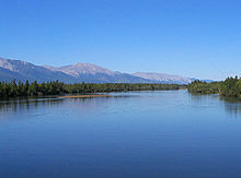
Novy Uoyan
| Urban-type settlement
Novy
Uoyan Novy Uoyan
|
||||||||||||||||||||||||||||
|
||||||||||||||||||||||||||||
|
||||||||||||||||||||||||||||

Novy Uojan ( Russian Новый Уоян ) is an urban-type settlement in the autonomous republic of Buryatia ( Russia ) with 3963 inhabitants (as of October 14, 2010).
geography
The settlement is located in the central part of the Upper Angara Depression , which is around 50 kilometers wide , which is enclosed in the north by the Upper Angara Mountains (Werchneangarsk Mountains) and in the south by the Northern Muja Mountains (Severomuisker Mountains), two mountain ranges over 2500 meters high in the Stanovoi Highlands . Nowy Uojan is located about 550 kilometers (as the crow flies) northeast of the republic capital Ulan-Ude and about eight kilometers from the left bank of the Upper Angara .
The settlement belongs to Severo-Baikalski Raion (North Baikal ), the administrative center of which is Nizhneangarsk, about 140 kilometers to the south-west.
history
The place arose in the mid-1970s not far from the village of Uojan, located on the left bank of the Upper Angara, in connection with the construction of the Baikal-Amur Mainline (BAM). The place name stands accordingly for New Uojan . The railway station and settlement were built by construction workers from the then Lithuanian SSR (as part of the propaganda about the All- Union Komsomol building object BAM, one or more regions of the former Soviet Union sponsored most of the stations and settlements to be built along the route).
In 1976 urban-type settlement status was given. Regular rail traffic on the entire section between Lake Baikal (Severobaikalsk) and Novaya Tschara in northern Transbaikalia began in 1989. After the completion of the railway line and as a result of the economic crisis from the end of the 1980s, more than half of the residents left the place because the expectations for the economic development of the area linked to the construction of the railway line were not fulfilled.
Population development
| year | Residents |
|---|---|
| 1979 | 5312 |
| 1989 | 9547 |
| 2002 | 4957 |
| 2010 | 3963 |
Note: census data
Economy and Infrastructure
Novy Uojan is an important station on the Baikal-Amur Mainline (1242 km from Taischet ), which is practically the only economic factor. Not far from the settlement, the route crosses the Upper Angara on a 350-meter-long bridge.
There are projects to build a 700 to 800-kilometer cross-connection between BAM and the Trans-Siberian Railway on the territory of Buryatia with the northern endpoint Novy Uojan, starting either from Novoiljinski (Trans-Siberian line kilometer 5736, area of the East Siberian Railway ), or from Mogson in neighboring Transbaikalia ( Transsib-km 6054, area of the Transbaikal Railway ). The route is intended to serve primarily the development of ore deposits, the lead - zinc -Lagerstätte Osjorninskoje that should be achieved according to plans by 2008 from the south already 2012th Due to a lack of funding, however, the route construction was frozen.
The road following the BAM also runs through Novy Uojan. From this a road branches off to the east of the settlement to the village of Kumora, almost 70 kilometers away. Its southern continuation into the valley of the Baikal tributary Barguzin , from which there is also a connection to the road network in southern Buryatia, which was tackled in the 1980s , has not yet been completed, so that this connection only exists in the form of a difficult-to-drive, unpaved runway.
Individual evidence
- ↑ a b Itogi Vserossijskoj perepisi naselenija 2010 goda. Tom 1. Čislennostʹ i razmeščenie naselenija (Results of the All-Russian Census 2010. Volume 1. Number and distribution of the population). Tables 5 , pp. 12-209; 11 , pp. 312–979 (download from the website of the Federal Service for State Statistics of the Russian Federation)
- ↑ Sergei Michaljow: Rudny put. In: Gudok ( RŽD daily newspaper ), October 16, 2008 (Russian)
- ↑ Report on the winter bike tour Novy Uojan – Irkutsk (Russian, photos)

