
La Orotava
| La Orotava municipality | |||
|---|---|---|---|
| coat of arms | Map of the Canary Islands | ||

|
|
||
| Basic data | |||
| Autonomous Community : | Canary Islands | ||
| Province : | Santa Cruz de Tenerife | ||
| Coordinates | 28 ° 22 ′ N , 16 ° 31 ′ W | ||
| Height : | 390 msnm | ||
| Area : | 207.31 km² | ||
| Residents : | 42,029 (Jan. 1, 2019) | ||
| Population density : | 202.74 inhabitants / km² | ||
| Postal code : | 38300 | ||
| Municipality number ( INE ): | 38026 | ||
| administration | |||
| Mayor : | Francisco Linares García ( CC ) | ||
| Address of the municipal administration: | Plaza del Ayuntamiento, s / n 38300 La Orotava |
||
| Website : | www.laorotava.es | ||
| Location of the municipality | |||

|
|||


La Orotava is a city and a municipality of the same name on the Canary Island of Tenerife .
Geography and climate
The urban area of La Orotava lies at an altitude of about 390 m above sea level, about 30 km west-southwest of Santa Cruz de Tenerife and northeast of Arona .
The municipal area extends from a short coastal tip on the northwest coast north of Puerto de la Cruz, mostly in the interior of the island to Pico de Teide. With 206.78 square kilometers , it is the largest of the 30 municipal areas of Tenerife and borders on 15 of them, these are: Icod de los Vinos , Puerto de la Cruz and Los Realejos in the north, Arafo and Santa Úrsula in the northeast, Fasnia and Güímar in the east , Arico in the southeast, Granadilla de Abona and Vilaflor in the south, Adeje in the southwest, Guía de Isora and Santiago del Teide in the west and La Guancha and San Juan de la Rambla in the northwest.
The charming location in the Orotava Valley (Valle de Orotava) has already attracted travelers 200 years ago. B. the natural scientist Alexander von Humboldt . The Mirador Humboldt (Humboldtblick) is named after him, a much-visited view over the valley. The Teide National Park , which was declared a UNESCO World Heritage Site in 2007 , is largely located in the urban area of La Orotava.
The humid climate here favors varied vegetation .
Transport and infrastructure
The city is an important cultural center of the island , it is connected to Santa Cruz de Tenerife by the northern TF-5 motorway. The closest airport is Los Rodeos . There are good bus connections to the surrounding towns as well as to La Laguna and Santa Cruz.
Population development
Course of population development
| year | Residents | Population density |
|---|---|---|
| 1991 (March 1) | 35,142 | 169.5 inhabitants / km² |
| 1996 (May 1st) | 35,642 | 171.9 inhabitants / km² |
| 2001 (November 1st) | 37,738 | 182.9 inhabitants / km² |
| 2002 | 39,095 | 188.6 inhabitants / km² |
| 2003 | 39,876 | 192.3 inhabitants / km² |
| 2004 | 39.909 | 192.5 inhabitants / km² |
| 2005 | 40,355 | 194.7 inhabitants / km² |
| 2006 | 40,644 | 196.2 inhabitants / km² |
| 2007 | 40,644 | 196.2 inhabitants / km² |
| 2008 | 40,945 | ./. |
| 2009 | 41,171 | ./. |
| 2010 | 41,427 | ./. |
| 2011 | 41,706 | ./. |
| 2012 | 41,726 | ./. |
| 2013 | 41,255 | ./. |
| 2014 | 41,179 | 198.6 inhabitants / km² |
economy
The agriculture is mainly from banana cultivation coined. After a long period of insignificance, viticulture is of a certain importance again . The vineyards in which wines are harvested , which later bear the designation of origin "Valle de la Orotava", extend over 974.4079 hectares. 661.8491 hectares of this are in the area of the city of La Orotava.
The tourism is a major source of income.
History of the city


After the conquest of Tenerife by troops commissioned by the Crown of Castile under the leadership of Adelantado Alonso Fernández de Lugo in 1496, the entire territory of the island was divided up for settlement purposes. The land in the Orotava Valley was considered particularly fertile and was therefore more sought-after than z. B. the dry area in the south of the island. The land in the Orotava Valley was therefore left to the relatives and close friends of the Adelantados in particular. The year 1504 is considered the year the town was founded. After a few disorderly settlements in today's urban area, plots, roads and other public areas were marked out in 1506 by the cavalry captain Diego de Mesa. The place was under the administration and jurisdiction of La Laguna . Some members of the island council ( cabildo ) were also based in La Orotava.
As one of the first measures, a public water pipe was built. This pipe led the water in an open channel from the springs in the mountains more than 10 km away to the town center and into the fields below. The material of the water pipe was initially wood. However, it was later largely replaced by stone. In the best times of the city, the water drove a sawmill and up to twelve gofio mills .
In addition to the cultivation of agricultural products for self-sufficiency, sugar cane was grown. Portuguese specialists from Madeira were recruited to build the three sugar factories in the La Orotava area. The slaves necessary for field work came from Africa. The wood heating medium necessary for the production of the sugar came from the mountains south of the village. Since sugar could be produced cheaper in America from the middle of the 17th century, agriculture switched to viticulture.
The port had to be expanded to ship export products. In 1603, Antonio Franchi Lutzardo y Ponte del Castillo, a member of the Island Council living in La Orotava, staked out streets, squares and building plots in Puerto de La Orotava, today's Puerto de la Cruz . A year later, the construction of the fortress "Castillo de San Felipe" began at the former landing site at Barranco Felipe. The viticulture and wine trade brought La Orotava a strong economic boom. A large part of the mansions, churches and monasteries dates from the 17th century, but was later redesigned according to the changing architectural ideas.
In 1648, against the declared will of the city of La Laguna, King Philip IV gave the place city rights. The decisions in the city were from now on made by an endogamous oligarchy of the "Twelve Families" for their own benefit. Some representatives of these families were raised to the margrave status of the Spanish Crown for their military services on the mainland or in the Italian possessions .
The earthquakes in connection with the volcanic eruption near Güímar in 1704/1705 caused damage to the main church Nuestra Señora de la Concepción, which was poorly repaired for years until the complete rebuilding of the church began in 1768.
After wine exports declined in the course of the 18th century due to various armed conflicts in Spain, especially with England, and damage to the vineyards by phylloxera , La Orotava's economic situation deteriorated. A boom through the cochineal was short-lived due to the invention of the aniline colors (late 19th century). At the beginning of the 20th century, banana cultivation brought about a certain economic recovery.
In 1906 Alfons XIII visited with . for the first time a ruling Spanish king the island of Tenerife and also La Orotava. During his visit, he granted the city the city coat of arms, which is still used today, and the title "Muy Noble y Leal Villa" (very loyal and elegant city).
The local incidents during the civil war have been investigated since 2008 in a commission set up by the city council.
The city experienced an economic boom from the middle of the 20th century through tourism.
By decree of the Government of the Autonomous Region of the Canary Islands on February 22, 2005, the city center is protected as a historical unit of cultural importance.
Buildings


The city center, both the “Villa” (lower town) and the somewhat simpler-looking district “Farrobo” (the upper town) are listed as an ensemble. In addition, individual buildings and two gardens have been declared "objects of special cultural importance" by the Canarian government. These are:
- The church “ Nuestra Señora de la Concepción ” from the end of the 18th century
- The Casa Lercaro (Ponte-Fonte), a building from the mid-17th century
- The cemetery, which was opened in 1823
- The buildings at calle calvario 52 and 54 are from 1725
- The remains of the aqueduct and the remaining buildings of the Gofio mills
- The "little daughter of the botanical garden", a branch of the larger Jardín de aclimatación de La Orotava in Puerto de la Cruz, which was laid out at the end of the 19th century
- The Jardines del Marquesado de la Quinta Roja (Jardin Victoria), a garden with a (never used) mausoleum for the VIII Marqués de la Quinta Roja
But other buildings and facilities in the city center are also worth seeing. B.
- The former monastery church of Santo Domingo from the 17th century
- The former Santo Domingo Monastery which now houses the Museum of Ibero-American Art
- The Casa Mesa from the beginning of the 17th century
- The former monastery church of San Agustin from the end of the 17th century
- The Casa Mendez-Fonseca (House of Balconies) from the middle of the 17th century
- The Casa Monteverde from the middle of the 17th century
- The Casa Jiménez-Franchi from the middle of the 17th century
- The Casa Molina from the end of the 16th century
- The town hall from the end of the 19th century
Customs and regular events
The feast of Corpus Christi (Corpus Cristi) is celebrated in downtown La Orotava a week later than anywhere else. Since 1847 the over 500 m long and z. The circular route of the procession, which takes place in the evening, is partly steeply inclined and decorated with a flower carpet (alfombra) . This carpet consists of individual images (tapices) and pattern areas (corridores) that merge into one another and are sprinkled with flower petals. The edges and the ground usually consist of finely chopped and partly roasted tree heather . The way of the procession is divided into about 50, depending on the local conditions, different sized sections. Starting in the early morning, the carpets are laid out by various groups or individuals (alfombristas) on the sections assigned to them, sometimes with the help of templates. Occasionally, preliminary drawings are made on the pavement on the eve of the festival. These groups are e.g. B. Neighborhood associations from different suburbs, different schools, groups of colleagues. Individuals (such as the mayor as a private person) are assigned certain sections and then also produce the drafts, but they can be helped by family or friends. Certain sections are traditionally designed by local families. Here, the activity in the community is obviously of greater importance for many participants than the (certainly worth seeing) result. Occasionally, foreign or even foreign groups are invited to take part.
On the town hall square, which is about halfway along the procession, a picture over 900 m² in size made of around 2,000 kg of differently colored sand has been scattered since 1912. The creation of this picture begins one month before Corpus Christi. For some years now, a tarpaulin has been stretched over the square during work to protect the picture from rain. The progress of the work can still be followed by the public from the top of the town hall stairs. The pictures (with the exception of the picture in 1931) are based on religious themes. After the procession, on Friday until around noon, the city cleaning service completely removed both the flowers and the sand.
On the Sunday following the local holiday of Corpus Cristi, there is the Romería de San Isidro, a celebration in honor of St. Isidro el Labrador , one of the patron saints of the city of La Orotava. On this day the farmers in their traditional costumes with their animals and music bands go through the city.
From the beginning of December to the feast of the Three Kings one is in the town square nativity scene set up with life-size figures depicting the life and the events in Bethlehem at the time of Christ's birth.
sons and daughters of the town
- Cristóbal Hernández de Quintana (1651–1725), sculptor and painter
- Fernando Estévez del Sacramento (1788–1854), sculptor and painter
- Tomás Machado y Méndez Fernández de Lugo (1908–2003), architect
- Ezequiel de León Domínguez (1926–2008), sculptor and restorer
- Cecilia Domínguez Luis (* 1948), writer
There are a few other personalities for whom La Orotava is given as the place of birth (e.g. the Iriarte brothers). However, these mostly come from the former district of Puerto de la Orotava, today's Puerto de la Cruz .
Impressions
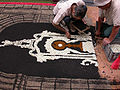
Work on one of the pictures of the Corpus Christi procession (2005)
The Christmas crib (Belén) with life-size figures (2006)

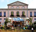
The town hall

Liceo de Taoro

San Agustín Church

Bell tower of San Agustín

Interior of San Agustín

Side and side altars in San Agustín

Main altar in San Agustín

Bandstand El Kiosco on the "Plaza de la Constitución"
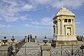
Mausoleum in the Jardines del Marquesado de la Quinta Roja (Jardin Victoria) park
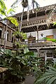
Courtyard of the Casa de los Balcones


swell
- ISTAC (Statistical Department of the Regional Government of the Canary Islands)
- Boletín Oficial de Canarias (Law and Bulletin of the Government of the Autonomous Region of the Canary Islands)
literature
- Antonio Luque Hernández: La Orotava, Corazón de Tenerife , Ayuntamiento de La Orotava, Islas Canarias 1998.
- A. Sebastián Hernández Gutiérez: El Jardín Artificial, Asociación de Alfombristas de la Villa de La Orotava, II Edición, La Orotava 2000.
- Manuel Méndez Guerrero, Isidoro Sánchez García, Juan Carlos Sánchez Reyes: La Orotava desde el mar hasta el Teide . Ed .: Excmo. Ayuntamiento de la Villa de La Orotava. La Orotava 2006, ISBN 84-933223-7-7 (Spanish, digitized [accessed December 9, 2017]).
Web links
Individual evidence
- ↑ Cifras oficiales de población resultantes de la revisión del Padrón municipal a 1 de enero . Population statistics from the Instituto Nacional de Estadística (population update).
- ↑ Población. Municipios por islas de Canarias y años. Instituto Canario de Estadística, accessed August 26, 2014 (Spanish).