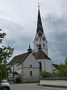
Pfeffikon
| Pfeffikon | ||
|---|---|---|
| State : |
|
|
| Canton : |
|
|
| Constituency : | Sursee | |
| Residential municipality : | Rickenbach | |
| Postal code : | 5735 | |
| former BFS no. : | 1096 | |
| Coordinates : | 655 852 / 233 185 | |
| Height : | 542 m above sea level M. | |
| Area : | 2.49 km² | |
| Residents: | 725 (December 31, 2012) | |
| Population density : | 291 inhabitants per km² | |
| Website: | www.rickenbach.ch | |
|
Pfeffikon village entrance |
||
| map | ||
|
|
||
Pfeffikon is a village in the Sursee district of the canton of Lucerne in Switzerland . It was an independent political municipality until the end of 2012 and merged with Rickenbach on January 1, 2013 .
geography
The former municipality is located in the Wynental / Michelsamt border area and the cantons of Lucerne and Aargau. The settlement focus is on the eastern slope and at the foot of the Stierenberg , which is 861 m above sea level. M. forms the highest point of the former municipality. The former community consists of the village (542 m above sea level), Eichbühl (585 m above sea level ) to the south and the Berg district (616 m above sea level) west of the village on the eastern slope of the Stierenberg. All three districts are quarters in the area west of Lake Hallwil , which have grown together. The Stierenberg is the only former part of the municipality that is forested.
The fact that the Stierenberg makes up a large proportion of the former municipal area of 247 hectares is shown by the fact that forest and woodland cover more than half (exactly 51.0%) of the municipal area. Another 38.9% is agricultural land and 10.1% is settlement area.
Pfeffikon bordered the communities Reinach AG and Menziken in the canton of Aargau to the north, east and south and Rickenbach LU to the west . The five villages of Reinach, Beinwil am See , Burg , Menziken and Pfeffikon have merged into a coherent agglomeration with around 19,500 inhabitants, the boundaries between the once separate settlements are barely recognizable.
population
| Population development | |
|---|---|
| year | Residents |
| 1798 | 340 |
| 1860 | 504 |
| 1888 | 403 |
| 1920 | 479 |
| 1930 | 427 |
| 1970 | 718 |
| 1980 | 700 |
| 1990 | 674 |
| 2000 | 686 |
| 2004 | 711 |
The population grew significantly from 1798 to 1860 (1798–1860: + 48.2%). This was followed by mass emigration until 1888 (1860–1888: −20.0%). After that, the number of inhabitants rose again significantly until 1920 (1888–1920: + 18.9%) due to the settlement of a large cigar factory. A decline in the 1920s was followed by an uninterrupted increase in population until 1970 (1930–1970: +68.1). The population fell slightly by 1990 - and then rose again to almost the level of 1970 by 2004.
Naturalized surname
A very well-known surname in Pfeffikon LU is Furrer. The Furrer family has been naturalized in this former village since 1614. Several "Furrers" have lived in the former village since 1614.
languages
The population uses a highly Alemannic dialect as their everyday language. At the last census in 2000, 91.25% said German, 2.92% Albanian and 1.75% Italian as their main language.
Religions - denominations
The entire population used to be members of the Roman Catholic Church. Today (as of 2000) the religious composition of the population is as follows: There are 55.54% Roman Catholic and 28.86% Evangelical Reformed Christians. There are also 6.56% non-religious and 4.81% Muslim. The majority of Muslims are Albanians from Kosovo and Macedonia. There are also a few Turks and Kurds.
Origin - nationality
Of the 703 inhabitants at the end of 2006, 609 were Swiss and 94 (= 13.4%) were foreigners. At the last census, 84.69% (including dual citizens 88.63%) were Swiss citizens. The largest groups of immigrants come from Serbia-Montenegro (mostly Albanians), Italy, Germany, Portugal and Macedonia.
traffic
Pfeffikon is not far from the Lucerne-Aarau road. A road connection leads via Burg AG to Rickenbach LU / Beromünster. The closest motorway connections are Sursee on the A2 in 16 km and Lenzburg AG on the A1 in 21 km.
history
The oldest evidence of settlement are the remains of a large Roman villa, which was built between 100 and 150 AD. A church dedicated to Mauritius was built between the 6th and 8th centuries. In a letter of protection from King Heinrich III. to the canons Beromünster is Faffinchoven first mentioned in the 1045th The Canon Monastery exercised lower jurisdiction until 1798. Even before the beginning of the 14th century, the place was owned by the Habsburgs . When a member of this family was ostracized by the emperor, the city of Lucerne took over the Michelsamt in 1415 , to which Pfeffikon belongs. From 1798 to 1803 the community belonged to the Münster (Beromünster) district, then to the newly created Sursee office . In the recent past there has been a lot of discussion about changing cantons from Lucerne to Aargau . The reason lies in the close interlinking with the settlement area of the neighboring communities with which Pfeffikon has grown together.
Attractions
See also
literature
- Adolf Reinle : The Art Monuments of the Canton of Lucerne, Volume IV: The Sursee Office. (= Art Monuments of Switzerland. Volume 35). Edited by the Society for Swiss Art History GSK. Bern 1956, ISBN 978-3-906131-23-8 .
Web links
- Official website of the municipality of Pfeffikon
- Community profile 2012 (PDF; 149 kB) on the cantonal website
- Waltraud Hörsch: Pfeffikon. In: Historical Lexicon of Switzerland .
Individual evidence
- ^ National map of Switzerland, sheets 1109 and 1110, Swisstopo


